Fil:Relief Map of Franz Josef Land.png
Det finns ingen version med högre upplösning.
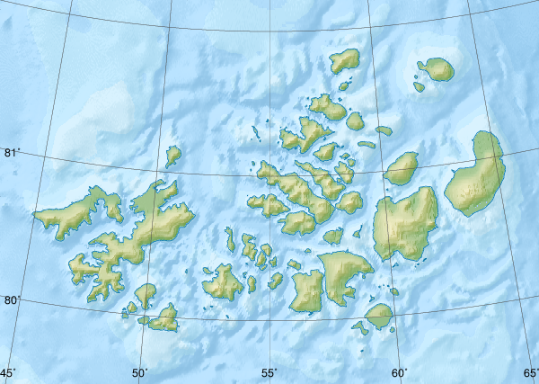
Relief_Map_of_Franz_Josef_Land.png (600 × 427 pixlar, filstorlek: 403 kbyte, MIME-typ: image/png)
| Denna fil tillhandahålls av Wikimedia Commons. Informationen nedan är kopierad från dess filbeskrivningssida. |
Sammanfattning
| Beskrivning |
Русский: Физическая карта -- Земля Франца-Иосифа, Россия.
|
| Datum | |
| Källa |
|
| Skapare | Nzeemin |
| Andra versioner |
|

Licensiering
Jag, upphovsrättsinnehavaren av detta verk, publicerar härmed det under följande licens:
Denna fil har gjorts tillgänglig under licensen Creative Commons Erkännande-Dela Lika 3.0 Unported
- Du är fri:
- att dela – att kopiera, distribuera och sända verket
- att remixa – att skapa bearbetningar
- På följande villkor:
- erkännande – Du måste ge lämpligt erkännande, ange en länk till licensen och indikera om ändringar har gjorts. Du får göra det på ett lämpligt sätt, men inte på ett sätt som antyder att licensgivaren stödjer dig eller din användning.
- dela lika – Om du remixar, transformerar eller bygger vidare på materialet måste du distribuera dina bidrag under samma eller en kompatibel licens som originalet.
Filhistorik
Klicka på ett datum/klockslag för att se filen som den såg ut då.
| Datum/Tid | Miniatyrbild | Dimensioner | Användare | Kommentar | |
|---|---|---|---|---|---|
| nuvarande | 17 oktober 2018 kl. 11.41 | | 600 × 427 (403 kbyte) | RosssW | Полуостров стал островом https://ru.wikipedia.org/wiki/Остров_Юрия_Кучиева |
| 15 maj 2012 kl. 19.57 |  | 600 × 427 (374 kbyte) | Nzeemin | bathymetry interpolated | |
| 7 april 2012 kl. 10.50 |  | 600 × 427 (251 kbyte) | Nzeemin | frame removed | |
| 17 mars 2012 kl. 21.14 |  | 600 × 427 (251 kbyte) | Nzeemin | plus bathymetry | |
| 10 mars 2012 kl. 21.57 |  | 600 × 427 (95 kbyte) | Nzeemin |
Filanvändning
Följande 2 sidor använder den här filen:
Global filanvändning
Följande andra wikier använder denna fil:
- Användande på az.wikipedia.org
- Användande på be.wikipedia.org
- Användande på cs.wikipedia.org
- Användande på de.wikipedia.org
- Hayes-Insel
- Wilczek-Insel
- Wilczekland
- Rudolf-Insel
- Graham-Bell-Insel
- Hall-Insel (Franz-Josef-Land)
- Alexandraland
- Prinz-Georg-Land
- Koldewey-Insel
- Wiener-Neustadt-Insel
- Hohenlohe-Insel
- Northbrook-Insel
- Hooker-Insel
- Eva-Liv-Insel
- Jackson-Insel
- Champ-Insel
- Alger-Insel
- Vorlage:Positionskarte Franz-Josef-Land
- Ziegler-Insel
- Salisbury-Insel
- McClintock-Insel
- Perlmutt-Insel
- Arthur-Insel
- La-Ronciere-Insel
- Bell-Insel
- Mabel-Insel
- Becker-Insel
- Greely-Insel
- Salm-Insel
- Kane-Insel
- Kuhn-Insel (Franz-Josef-Land)
- Karl-Alexander-Insel
- Hoffmann-Insel
- Lütke-Insel
- Brosch-Insel
- Hochstetter-Inseln
- Luigi-Insel
- Bruce-Insel
Visa mer globalt användande av denna fil.