Fil:New Zealand map.PNG
New_Zealand_map.PNG (323 × 590 pixlar, filstorlek: 89 kbyte, MIME-typ: image/png)
| Denna fil tillhandahålls av Wikimedia Commons. Informationen nedan är kopierad från dess filbeskrivningssida. |
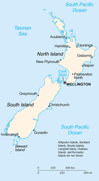
A map of New Zealand showing the major cities and towns. Not shown are the Antipodes Islands, Auckland Islands, Bounty Islands, Campbell Island, The Snares, and the Kermadec Islands.
https://www.cia.gov/library/publications/the-world-factbook/geos/nz.html archive copy at the Wayback Machine
It should be noted that the scale on this map is not accurate. Measuring distances on the map then using the scale to determine those distances on the ground would lead to considerable exaggeration of those distances. This issue has been raised with the CIA, who compile these World Fact Book maps.
- Update - the latest version updated by Grutness is much better. Please see the Talk page for more.
This image is in the public domain because it contains materials that originally came from the United States Central Intelligence Agency's World Factbook.
|
 |
Filhistorik
Klicka på ett datum/klockslag för att se filen som den såg ut då.
| Datum/Tid | Miniatyrbild | Dimensioner | Användare | Kommentar | |
|---|---|---|---|---|---|
| nuvarande | 30 juli 2005 kl. 03.14 | | 323 × 590 (89 kbyte) | Grutness | scale corrected |
| 30 juli 2005 kl. 03.04 |  | 323 × 590 (100 kbyte) | Grutness | Scale corrected | |
| 6 maj 2005 kl. 06.24 |  | 323 × 590 (21 kbyte) | Evil Monkey | World Factbook map cropped and modified but still PD |
Filanvändning
Följande 4 sidor använder den här filen:
Global filanvändning
Följande andra wikier använder denna fil:
- Användande på an.wikipedia.org
- Användande på bbc.wikipedia.org
- Användande på be-tarask.wikipedia.org
- Användande på br.wikipedia.org
- Användande på bs.wikipedia.org
- Användande på cs.wikipedia.org
- Användande på de.wikipedia.org
- Användande på de.wikinews.org
- Användande på en.wikipedia.org
- Användande på en.wiktionary.org
- Användande på es.wikinews.org
- Användande på eu.wikipedia.org
- Användande på fr.wikipedia.org
- Användande på fr.wiktionary.org
- Användande på gd.wikipedia.org
- Användande på gl.wikipedia.org
- Användande på he.wikipedia.org
- Användande på hi.wikipedia.org
- Användande på hr.wikipedia.org
- Användande på io.wikipedia.org
- Användande på it.wikipedia.org
- Användande på ka.wikipedia.org
- Användande på la.wikipedia.org
- Användande på lt.wikipedia.org
- Användande på ml.wikipedia.org
- Användande på mr.wikipedia.org
- Användande på nds-nl.wikipedia.org
- Användande på nl.wikipedia.org
- Användande på nn.wikipedia.org
- Användande på no.wikipedia.org
- Användande på pl.wikipedia.org
- Användande på pl.wikibooks.org
- Användande på pl.wikivoyage.org
- Användande på pt.wikipedia.org
- Användande på ru.wikipedia.org
- Användande på ru.wikinews.org
- Användande på sr.wikipedia.org
- Användande på sw.wikipedia.org
Visa mer globalt användande av denna fil.