Fil:Ww2 europe map italy june until december 1944.jpg

Storlek på förhandsvisningen: 785 × 599 pixlar. Andra upplösningar: 314 × 240 pixlar | 629 × 480 pixlar | 1 006 × 768 pixlar | 1 265 × 966 pixlar.
Originalfil (1 265 × 966 pixlar, filstorlek: 1,89 Mbyte, MIME-typ: image/jpeg)
| Denna fil tillhandahålls av Wikimedia Commons. Informationen nedan är kopierad från dess filbeskrivningssida. |
Sammanfattning
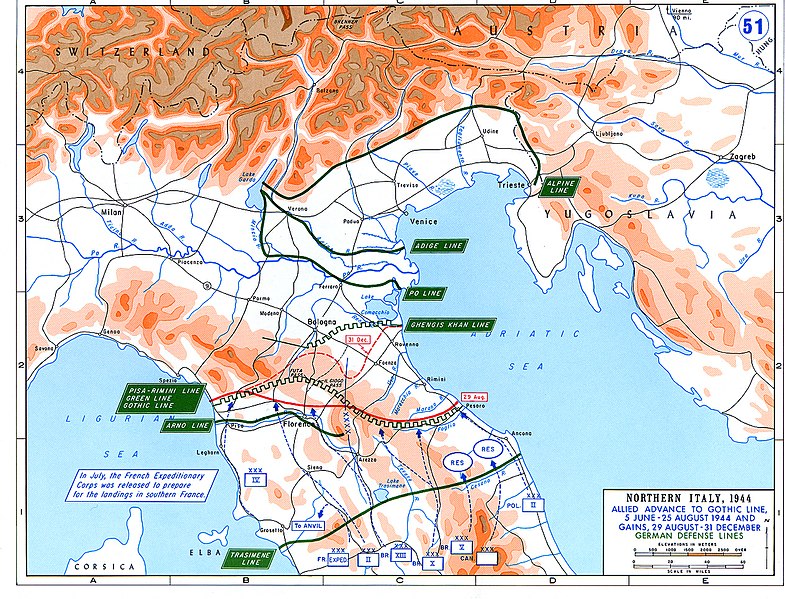
| Beskrivning |
English: Allied Corp formations are depicted in blue. The German defensive lines are shown in green. The solid red line denotes the extent of the Allied advance by 29 August 1944, and the dotted red line is the extent of the Allied advance by 31 December 1944. |
| Datum | |
| Källa | Archive link to original website used for the map and the archive link to the map source page. |
| Skapare | The History Department of the United States Military Academy |
| Tillstånd (Återanvändning av denna fil) |
US Government document |
| Andra versioner |
The current version of the map by the The History Department of the United States Military Academy: |

Licensiering
This file is a work of a U.S. Army soldier or employee, taken or made as part of that person's official duties. As a work of the U.S. federal government, it is in the public domain in the United States.
|
 |
Filhistorik
Klicka på ett datum/klockslag för att se filen som den såg ut då.
| Datum/Tid | Miniatyrbild | Dimensioner | Användare | Kommentar | |
|---|---|---|---|---|---|
| nuvarande | 20 februari 2021 kl. 05.25 | | 1 265 × 966 (1,89 Mbyte) | Buidhe | Reverted to version as of 14:07, 29 February 2020 (UTC) Not a minor change, should be uploaded as new file |
| 20 februari 2021 kl. 04.57 |  | 973 × 754 (349 kbyte) | EnigmaMcmxc | updated version of the map | |
| 29 februari 2020 kl. 16.07 |  | 1 265 × 966 (1,89 Mbyte) | Hohum | Fix colour profile | |
| 22 juni 2011 kl. 20.21 |  | 1 265 × 966 (1,93 Mbyte) | Hohum | Cleanup | |
| 10 december 2006 kl. 14.26 |  | 1 265 × 966 (2,01 Mbyte) | MatthiasKabel | == License information == {{PD-Layout}} {{PD-USGov}} Original from http://www.dean.usma.edu/history/web03/atlases/ww2%20europe/ww2%20europe%20war%20index.htm |
Filanvändning
Följande sida använder den här filen:
Global filanvändning
Följande andra wikier använder denna fil:
- Användande på af.wikipedia.org
- Användande på ar.wikipedia.org
- Användande på cs.wikipedia.org
- Användande på de.wikipedia.org
- Användande på en.wikipedia.org
- Användande på es.wikipedia.org
- Användande på fi.wikipedia.org
- Användande på fr.wikipedia.org
- Användande på he.wikipedia.org
- Användande på hu.wikipedia.org
- Användande på id.wikipedia.org
- Användande på it.wikipedia.org
- Användande på ja.wikipedia.org
- Användande på nl.wikipedia.org
- Användande på no.wikipedia.org
- Användande på pl.wikipedia.org
- Användande på pt.wikipedia.org
- Användande på ru.wikipedia.org
- Användande på sk.wikipedia.org
- Användande på sl.wikipedia.org
- Användande på sr.wikipedia.org
- Användande på ta.wikipedia.org
- Användande på uk.wikipedia.org
- Användande på www.wikidata.org
- Användande på zh.wikipedia.org