Fil:Uvea wallis island.jpg

Storlek på förhandsvisningen: 403 × 599 pixlar. Andra upplösningar: 161 × 240 pixlar | 323 × 480 pixlar | 640 × 952 pixlar.
Originalfil (640 × 952 pixlar, filstorlek: 184 kbyte, MIME-typ: image/jpeg)
| Denna fil tillhandahålls av Wikimedia Commons. Informationen nedan är kopierad från dess filbeskrivningssida. |
Sammanfattning
| Beskrivning |
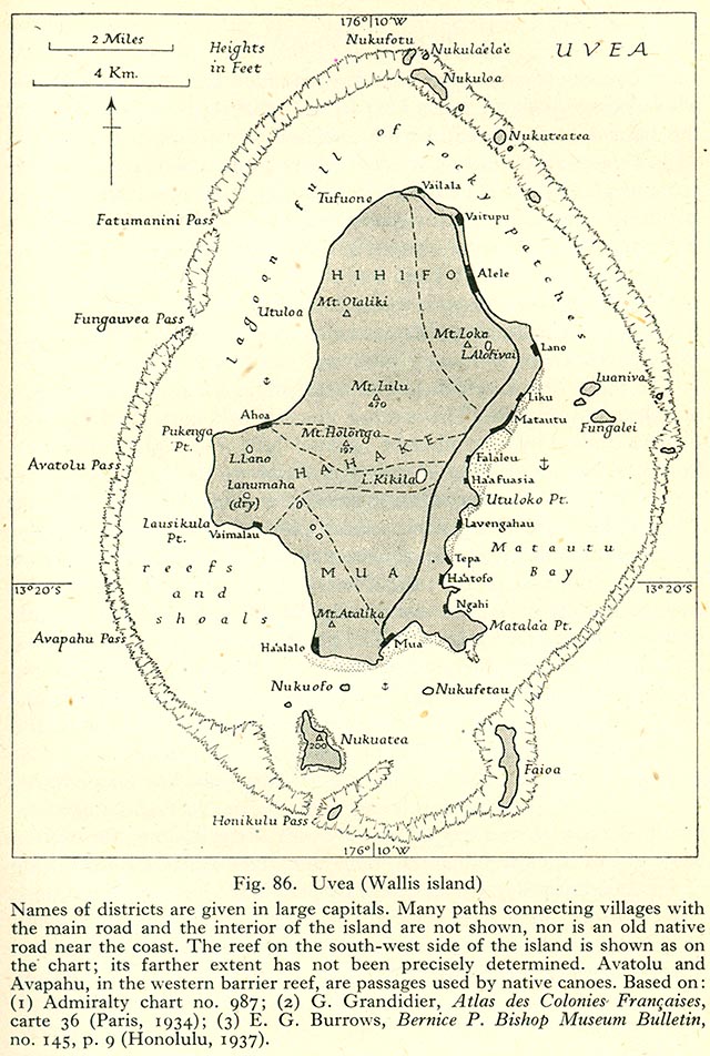
English: 1944 Map of Wallis Island (ʻUvea) Français : Carte de Wallis (ʻUvea) de 1944 |
| Datum | |
| Källa | http://www.lib.utexas.edu/maps/historical/pacific_islands_1943_1945/uvea_wallis_island.jpg Geographical Handbook Series, Great Britain. Admiralty. Naval Intelligence Division, 1943-1945 - Volume III : Western Pacific (Tonga to Solomon Islands), 1944. Taken from the University of Texas Library. |
| Skapare | Admiralty. Naval Intelligence Division. |
Licensiering
This work created by the United Kingdom Government is in the public domain.
This is because it is one of the following:
HMSO has declared that the expiry of Crown Copyrights applies worldwide (ref: HMSO Email Reply)
|
 |
Filhistorik
Klicka på ett datum/klockslag för att se filen som den såg ut då.
| Datum/Tid | Miniatyrbild | Dimensioner | Användare | Kommentar | |
|---|---|---|---|---|---|
| nuvarande | 11 november 2006 kl. 19.40 | | 640 × 952 (184 kbyte) | Ratzer |
Filanvändning
Följande sida använder den här filen:
Global filanvändning
Följande andra wikier använder denna fil:
- Användande på de.wikipedia.org
- Användande på en.wikipedia.org
- Användande på fa.wikipedia.org
- Användande på it.wikipedia.org
- Användande på it.wikivoyage.org
- Användande på la.wikipedia.org
- Användande på pl.wikipedia.org
- Användande på ru.wikipedia.org
- Användande på uk.wikipedia.org