Un-mali_Kayes_Region.png(692 × 594 pixlar, filstorlek: 208 kbyte, MIME-typ: image/png)

Sammanfattning

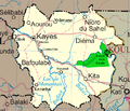
Beskrivning Map of the Kayes Region of Mali. Additions include new northern road via Diema, several towns, downgrade of road (in fact unpaved) from Kayes to Kenieba. Solid pink lines are paved, dashed are unpaved. Addition of National park of Boucle du Baoule. Ref: Ross Velton. Mali. Bradt UK and Globe Pequot US (2005/2006) ISBN 9781841620770 Made with GIMP
Datum
Källa self-made, edit, crop, recolored, several additions to Image:Un-mali.png from http://www.un.org/Depts/Cartographic/english/htmain.htm
Skapare T L Miles
Tillstånd
(Återanvändning av denna fil)

Modified versions of UNCS maps may be used provided that the UN name and reference number does not appear on any modified version and a link to the original map is provided. Modified UN maps are to be considered in the public domain. This applies worldwide SEE:

Public domain This image is a map derived from a United Nations map.

Unless stated otherwise, UN maps are to be considered in the public domain. This applies worldwide.
Some UN maps have special copyrights, as indicated on the map itself.

UN maps are, in principle, open source material and you can use them in your work or for making your own map. UN requests however that you delete the UN name, logo and reference number upon any modification to the map. Content of your map will be your responsibility. You can state in your publication, if you wish, something like: based on UN map … (map name, map number, revision number and date). See: Geospatial Information Section. And: Geospatial, location data for a better world.

Andra versioner Image:Un-mali.png

Licensiering

Public domain Jag, upphovsrättsinnehavaren till detta verk, släpper detta verk i public domain. Detta gäller globalt.
I vissa länder kan detta inte vara juridiskt möjligt; i så fall:
Jag ger härmed envar rätten att använda detta verk för alla ändamål, utan några villkor, förutom villkor som lagen ställer.

Bildtexter

Ingen bildtext har definierats

Objekt som porträtteras i den här filen

motiv

Filhistorik

Klicka på ett datum/klockslag för att se filen som den såg ut då.

Datum/TidMiniatyrbildDimensionerAnvändareKommentar
nuvarande4 mars 2008 kl. 20.42Miniatyrbild för versionen från den 4 mars 2008 kl. 20.42692 × 594 (208 kbyte)T L Miles{{Information |Description=Map of the Kayes Region of Mali. Additions include new northern road via Diema, several towns, downgrade of road (in fact unpaved) from Kayes to Kenieba. Solid pink lines are paved, dashed are unpaved. Addition of National pa

Följande sida använder den här filen:

Global filanvändning

Följande andra wikier använder denna fil: