Fil:Trafalgar 1200hr.gif
Storlek på förhandsvisningen: 635 × 600 pixlar. Andra upplösningar: 254 × 240 pixlar | 508 × 480 pixlar | 900 × 850 pixlar.
Originalfil (900 × 850 pixlar, filstorlek: 30 kbyte, MIME-typ: image/gif)
| Denna fil tillhandahålls av Wikimedia Commons. Informationen nedan är kopierad från dess filbeskrivningssida. |

|
Denna fil är nu ersatt av File:Trafalgar 1200hr.svg. Vänligen använd den andra filen. Notera att ersatta bilder i normala fall inte ska raderas. Orsak: The new file is SVG, and has less spelling mistakes
|

|
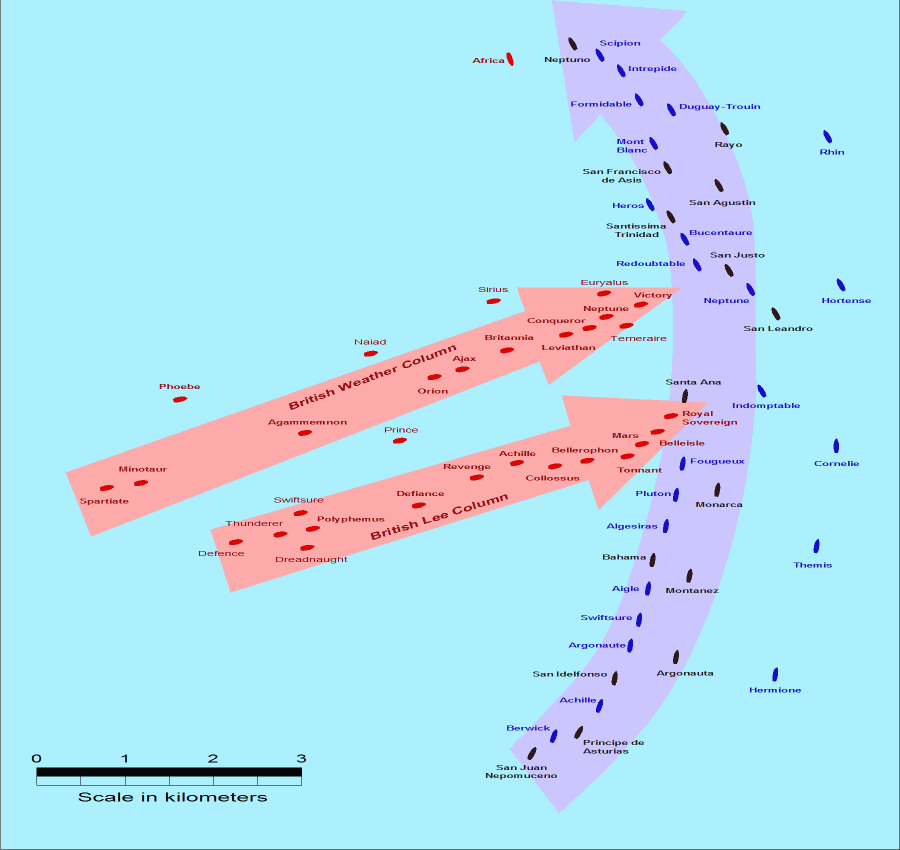
- Description: This map of the Battle of Trafalgar shows the approximate position of the two fleets at 1200 hours during the battle as the Royal Sovereign was breaking into the Franco-Spanish line. North is to the top, and Cape Trafalgar is 10 miles to the northeast.
- Size: 900 × 850 pixels.
- Source: This drawing is based on an illustration in issue number 84 of the Strategy & Tactics magazine The map was made by RJHall using the Campaign Cartographer drawing program, and the image was reduced in size 50% in Paint Shop Pro. Ship icons are not to scale.
Denna fil har gjorts tillgänglig under licensen Creative Commons Erkännande-Dela Lika 2.5 Generisk
- Du är fri:
- att dela – att kopiera, distribuera och sända verket
- att remixa – att skapa bearbetningar
- På följande villkor:
- erkännande – Du måste ge lämpligt erkännande, ange en länk till licensen och indikera om ändringar har gjorts. Du får göra det på ett lämpligt sätt, men inte på ett sätt som antyder att licensgivaren stödjer dig eller din användning.
- dela lika – Om du remixar, transformerar eller bygger vidare på materialet måste du distribuera dina bidrag under samma eller en kompatibel licens som originalet.
Filhistorik
Klicka på ett datum/klockslag för att se filen som den såg ut då.
| Datum/Tid | Miniatyrbild | Dimensioner | Användare | Kommentar | |
|---|---|---|---|---|---|
| nuvarande | 28 juli 2005 kl. 16.30 | | 900 × 850 (30 kbyte) | RJHall | Battle of Trafalgar situation at 1200hr, 21 October 1805. |
Filanvändning
Inga sidor använder den här filen.
Global filanvändning
Följande andra wikier använder denna fil:
- Användande på fr.wikipedia.org
- Användande på ja.wikipedia.org