Fil:TalladegaSuperspeedway2.jpg

Storlek på förhandsvisningen: 800 × 600 pixlar. Andra upplösningar: 320 × 240 pixlar | 640 × 480 pixlar | 1 024 × 768 pixlar | 1 280 × 960 pixlar | 2 576 × 1 932 pixlar.
Originalfil (2 576 × 1 932 pixlar, filstorlek: 804 kbyte, MIME-typ: image/jpeg)
| Denna fil tillhandahålls av Wikimedia Commons. Informationen nedan är kopierad från dess filbeskrivningssida. |
Sammanfattning
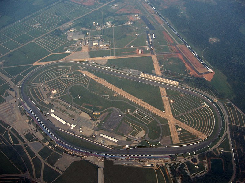
| Beskrivning | This image is of the Talladega Superspeedway, located in Talladega, Alabama. The image was taken from approximately 5000ft MSL (4500ft AGL) with visibility limited to approximately 4sm due to haze. The left wheel of the aircraft has been digitally removed from the image, causing some distortion in the lower sections, just below the track. The old w:Talladega Municipal Airport runways are still visible, crossing inside the track. The new airport and runway are located in the background, just north east of the track's position. |
| Datum | |
| Källa | Eget arbete |
| Skapare | AuburnPilot |
| Kameraposition | | Se denna och andra närliggande bilder på: OpenStreetMap |
|---|
Licensiering
| Jag, upphovsrättsinnehavaren till detta verk, släpper detta verk i public domain. Detta gäller globalt. I vissa länder kan detta inte vara juridiskt möjligt; i så fall: Jag ger härmed envar rätten att använda detta verk för alla ändamål, utan några villkor, förutom villkor som lagen ställer. |
Filhistorik
Klicka på ett datum/klockslag för att se filen som den såg ut då.
| Datum/Tid | Miniatyrbild | Dimensioner | Användare | Kommentar | |
|---|---|---|---|---|---|
| nuvarande | 9 september 2007 kl. 06.51 | | 2 576 × 1 932 (804 kbyte) | AuburnPilot | {{Information |Description=This image is of the Talladega Superspeedway, located in Talladega, Alabama. The image was taken from approximately 5000ft MSL (4500ft AGL) with visibility limited to approx |
Filanvändning
Följande sida använder den här filen:
Global filanvändning
Följande andra wikier använder denna fil:
- Användande på ast.wikipedia.org
- Användande på ca.wikipedia.org
- Användande på cs.wikipedia.org
- Användande på de.wikipedia.org
- Användande på en.wikipedia.org
- Talladega, Alabama
- Talladega Superspeedway
- 2007 UAW-Ford 500
- 2008 AMP Energy 500
- 2009 Aaron's 499
- 2010 AMP Energy Juice 500
- 2011 Aaron's 499
- 2012 Aaron's 499
- 2012 Good Sam Roadside Assistance 500
- 2013 Aaron's 499
- 2013 Camping World RV Sales 500
- User:AuburnPilot/Images
- 2014 Aaron's 499
- 2006 UAW-Ford 500
- 2015 GEICO 500
- 2015 CampingWorld.com 500 at Talladega
- 2016 GEICO 500
- 2016 Hellmann's 500
- 2017 GEICO 500
- 2017 Alabama 500
- 2018 GEICO 500
- 2018 1000Bulbs.com 500
- 2019 GEICO 500
- 2019 MoneyLion 300
- 2019 Sugarlands Shine 250
- 2019 1000Bulbs.com 500
- 2020 GEICO 500
- 2020 YellaWood 500
- 2021 GEICO 500
- 2021 YellaWood 500
- 2012 Aaron's 312
- 2022 YellaWood 500
- 2023 GEICO 500
- 2013 Fred's 250
- 2010 Aaron's 312
- 2023 YellaWood 500
- 2008 Aaron's 312
- 2007 Aaron's 312
- 2009 Aaron's 312
- 2011 Aaron's 312
- 2024 GEICO 500
- 2024 Ag-Pro 300
- 2024 General Tire 200 (Talladega)
- Användande på es.wikipedia.org
Visa mer globalt användande av denna fil.