Fil:Offa dioceses.gif
Det finns ingen version med högre upplösning.
Offa_dioceses.gif (670 × 566 pixlar, filstorlek: 174 kbyte, MIME-typ: image/gif)
| Denna fil tillhandahålls av Wikimedia Commons. Informationen nedan är kopierad från dess filbeskrivningssida. |
| Beskrivning |
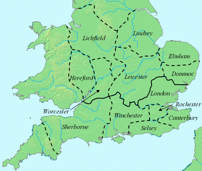
English: This map shows dioceses in England during the reign of Offa. The boundary between the archdioceses of Lichfield and Canterbury is shown in bold. Initially on w:en:Image:Offa dioceses.gif |
| Datum | |
| Källa |
Eget arbete med hjälp av: |
| Skapare | w:en:User:Mike Christie |
The original upload says
- current 16:51, 6 January 2008 w:en:User:Mike Christie (Talk | contribs) 670×566 174 KB This map shows dioceses in England during the reign of Offa. The boundary between the archdioceses of Lichfield and Canterbury is shown in bold. This file was created using DMIS archive copy at the Wayback Machine. On that site it is [http://supp
| |
Denna bild har släppts fri (eller släpps härmed fri) till public domain av dess skapare, Mike Christie på det Wikimedia Commons-projektet. Detta gäller över hela världen. Om detta strider mot lagstiftning: |
Filhistorik
Klicka på ett datum/klockslag för att se filen som den såg ut då.
| Datum/Tid | Miniatyrbild | Dimensioner | Användare | Kommentar | |
|---|---|---|---|---|---|
| nuvarande | 8 mars 2008 kl. 16.31 | | 670 × 566 (174 kbyte) | Cæruleum | {{Information |Description=This map shows dioceses in England during the reign of Offa. The boundary between the archdioceses of Lichfield and Canterbury is shown in bold. This file was created using [http://www.demis.nl/home/pages/home.htm DMIS]. On t |
Filanvändning
Följande sida använder den här filen:
Global filanvändning
Följande andra wikier använder denna fil:
- Användande på arz.wikipedia.org
- Användande på azb.wikipedia.org
- Användande på ca.wikipedia.org
- Användande på de.wikipedia.org
- Användande på el.wikipedia.org
- Användande på en.wikipedia.org
- Användande på es.wikipedia.org
- Användande på fi.wikipedia.org
- Användande på gl.wikipedia.org
- Användande på id.wikipedia.org
- Användande på ja.wikipedia.org
- Användande på pl.wikipedia.org
- Användande på pt.wikipedia.org
- Användande på ru.wikipedia.org