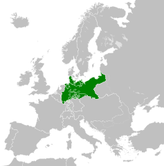
Fil:North German Confederation 1870.svg

Storleken för denna PNG-förhandsvisning av denna SVG-fil: 450 × 456 pixlar. Andra upplösningar: 237 × 240 pixlar | 474 × 480 pixlar | 758 × 768 pixlar | 1 011 × 1 024 pixlar | 2 021 × 2 048 pixlar.
Originalfil (SVG-fil, standardstorlek: 450 × 456 pixlar, filstorlek: 705 kbyte)
| Denna fil tillhandahålls av Wikimedia Commons. Informationen nedan är kopierad från dess filbeskrivningssida. |
Sammanfattning
Den här W3C-overifiera vektorbilden skapades med Inkscape .


.svg)
.svg)
.svg)
.svg)
.svg)


.svg)
.svg)
.svg)


.png)
.png)


.svg)


.svg)

.svg)


.svg)
.svg)
.svg)
.svg)


.svg)
.png)


.svg)


.svg)
.svg)


.svg)


.svg)


.svg)
.svg)
.svg)
.svg)
.svg)
.svg)
.svg)
_cropped.svg)
.svg)
.svg)
.svg)
.svg)
.svg)
.svg)
.svg)
.svg)
.svg)
.svg)
.svg)
.svg)
.svg)
.svg)
.svg)
.svg)
.svg)
.svg)
.svg)
.svg)
.svg)
.svg)
.svg)
.svg)
.svg)
.svg)
.svg)
.svg)
.svg)
.svg)
.svg)
.svg)
.svg)
.svg)
.svg)
.svg)
.svg)
.svg)
.svg)
.svg)
.svg)
.svg)
.svg)
.svg)
.svg)
Licensiering
Denna fil har gjorts tillgänglig under licensen Creative Commons Erkännande-DelaLika 4.0 Internationell.
- Du är fri:
- att dela – att kopiera, distribuera och sända verket
- att remixa – att skapa bearbetningar
- På följande villkor:
- erkännande – Du måste ge lämpligt erkännande, ange en länk till licensen och indikera om ändringar har gjorts. Du får göra det på ett lämpligt sätt, men inte på ett sätt som antyder att licensgivaren stödjer dig eller din användning.
- dela lika – Om du remixar, transformerar eller bygger vidare på materialet måste du distribuera dina bidrag under samma eller en kompatibel licens som originalet.
Filhistorik
Klicka på ett datum/klockslag för att se filen som den såg ut då.
| Datum/Tid | Miniatyrbild | Dimensioner | Användare | Kommentar | |
|---|---|---|---|---|---|
| nuvarande | 1 juni 2016 kl. 04.58 | | 450 × 456 (705 kbyte) | Alphathon | Various corrections to the states of the North German Confederation |
| 31 maj 2016 kl. 07.22 |  | 450 × 456 (662 kbyte) | Alphathon | Uploaded wrong file | |
| 31 maj 2016 kl. 07.22 |  | 450 × 456 (725 kbyte) | Alphathon | Minor corrections (Tarasp and post-1818 German Confederation border change) | |
| 31 maj 2016 kl. 04.40 |  | 450 × 456 (662 kbyte) | Alphathon | == {{int:filedesc}} == {{Inkscape}} {{Information |Description={{en|A map of the en:North German Confederation within Europe circa 1870 CE.}} |Source= {{Derived from|Blank_map_of_Europe.svg|display=50}} |Date=2016-05-31 |Author=*[[:File:Bla... |
Filanvändning
Följande sida använder den här filen:
Global filanvändning
Följande andra wikier använder denna fil:
- Användande på ang.wikipedia.org
- Användande på ar.wikipedia.org
- Användande på azb.wikipedia.org
- Användande på bg.wikipedia.org
- Användande på cs.wikipedia.org
- Användande på en.wikipedia.org
- Användande på es.wikipedia.org
- Användande på eu.wikipedia.org
- Användande på fa.wikipedia.org
- Användande på fi.wikipedia.org
- Användande på fr.wikipedia.org
- Användande på he.wikipedia.org
- Användande på hr.wikipedia.org
- Användande på is.wikipedia.org
- Användande på it.wikipedia.org
- Användande på ko.wikipedia.org
- Användande på lt.wikipedia.org
- Användande på lv.wikipedia.org
- Användande på ms.wikipedia.org
- Användande på pl.wikipedia.org
- Användande på pt.wikipedia.org
- Användande på ru.wikipedia.org
- Användande på th.wikipedia.org
- Användande på tr.wikipedia.org
- Användande på vi.wikipedia.org
- Användande på zh.wikipedia.org