Fil:Nevada TTR Chart.jpg

Storlek på förhandsvisningen: 755 × 600 pixlar. Andra upplösningar: 302 × 240 pixlar | 604 × 480 pixlar | 967 × 768 pixlar | 1 280 × 1 017 pixlar | 2 560 × 2 034 pixlar | 4 997 × 3 970 pixlar.
Originalfil (4 997 × 3 970 pixlar, filstorlek: 23,09 Mbyte, MIME-typ: image/jpeg)
| Denna fil tillhandahålls av Wikimedia Commons. Informationen nedan är kopierad från dess filbeskrivningssida. |
Sammanfattning

|
Denna bild flyttades till Wikimedia Commons från en.wikipedia med hjälp av ett botskript. All källinformation finns fortfarande kvar. En granskning krävs. Det kan finnas fel i några eller alla informationsfält; informationen för denna bild bör inte anses vara tillförlitlig och bör inte användas förrän den har granskats och korrigerats om det behövs. Så fort granskningen har slutförts bör denna mall tas bort. För fler detaljer, se nedan. Kolla nu! |
| Beskrivning |
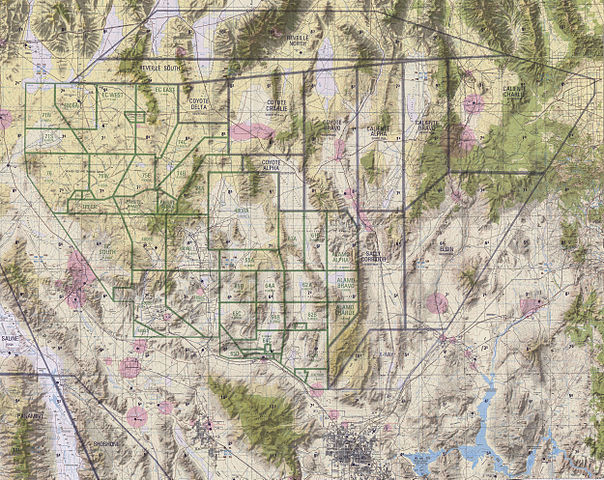
English: The five geographical areas of the Nellis Range Complex consist of: Restricted Areas R-4806, primarily used for testing and munitions training; R-4807, used for electronic combat and munitions training; R-4808, used by the Nevada Test Site; R-4809, used primarily as an electronic combat range; and the Desert Military Operating Area, used for air-to-air training. The Nellis Range Complex is located between Las Vegas and Tonopah in Southwestern Nevada and consists of five adjacent geographical areas. The ground is mostly barren, consisting mainly of flat, dry lake beds, dry washes, desert vegetation, and rugged, mountainous terrain. The land occupied by the NRC is more than , combined with more than of airspace. The 99th Range Squadron, which controls the range, is located on Nellis Air Force Base, approximately northeast of Las Vegas.The NAFR consists of approximately . The majority of the NAFR consists of lands withdrawn from the BLM. Withdrawn lands refers to land which is set aside for a specific use. In this case, it is land that has been set aside for military use that is not available for public use. It remains under the jurisdiction and management of the agency that is responsible for the land. The Air Force must comply with all uses, policies, programs, federal requirements as mandated and administered through BLM. The Nevada Wild Horse Range is included in the NAFR and is administered by the BLM. Approximately of the NAFR have been withdrawn from the Desert National Wildlife Range (DNWR). The Air Force and USFWS jointly manage this area. The Nevada Test Site, administered by the DOE, is contiguous with the NAFR in the southwestern part of the NRC. Public access to the NAFR and the Nevada Test Site is highly restricted, although some areas support grazing leases. The NAFR is used for training, testing, and weapons evaluation operations for the Air Force, Army, Marine Corps, National Guard, Navy, DOE, and reserve forces. Target complexes with bombing circles and triangles, and simulated runways, airfields, and convoys are situated on parts of the NAFR. |
| Datum | (UTC) |
| Källa | NGSIA |
| Skapare | NGSIA |
Licensiering
Detta verk är under public domain (allmän egendom) i USA då verket gjordes av en tjänsteman eller anställd i USA: s regering som en del av den personens officiella arbete i enlighet med villkoren i Title 17, Kapitel 1, Sektion 105 av US Code (Amerikas förenta staters kodifierade lagsamling). Läs gärna Copyright (på engelska).
Observera: Detta gäller endast originalverk av den federala regeringen och inte till arbetet i någon enskild amerikansk delstat, amerikansk territorium, samhälle, län, kommun, eller någon annan delsektion. Den här mallen gäller även inte för frimärksmotiv som gjots och eller producerats av United States Postal Service efter 1978. (Se 206.02(b) of Compendium II: Copyright Office Practices). Det gäller inte heller för vissa amerikanska mynt; se The US Mint Terms of Use.
|
 | |
| Denna fil har identifierats som fri från kända begränsningar enligt upphovsrätten, inklusive alla relaterade och närliggande rättigheter. | ||
Ursprunglig uppladdningslogg
Överförd från en.wikipedia till Commons från Fredlyfish4 med användning av CommonsHelper.
Den ursprungliga beskrivningssidan fanns här. Alla följande användarnamn finns på en.wikipedia.
- 2010-06-14 00:50 Flakeyswilson 4997×3970× (24210244 bytes) {{Information |Description = |Source = |Date = ~~~~~ |Author = |Permission = |other_versions = }}
Filhistorik
Klicka på ett datum/klockslag för att se filen som den såg ut då.
| Datum/Tid | Miniatyrbild | Dimensioner | Användare | Kommentar | |
|---|---|---|---|---|---|
| nuvarande | 10 februari 2013 kl. 23.31 | | 4 997 × 3 970 (23,09 Mbyte) | File Upload Bot (Magnus Manske) | Transfered from en.wikipedia by User:Fredlyfish4 using CommonsHelper |
Filanvändning
Följande 3 sidor använder den här filen: