Fil:Mapa político de España, 1850.jpg

Originalfil (1 800 × 1 322 pixlar, filstorlek: 399 kbyte, MIME-typ: image/jpeg)
| Denna fil tillhandahålls av Wikimedia Commons. Informationen nedan är kopierad från dess filbeskrivningssida. |
Sammanfattning
Source
This map comes from:
- Francisco Jorge Torres Villegas, Cartografía hispano-científica ó sea los mapas españoles en que se representa bajo sus diferentes fases. Imprenta de don José María Alonso, 1852 (1ª ed.) y 1857 (2ª ed.).
- (Spanish Scientific cartography, that is the Maps about Spain in which it is represented its evolution. Printed by Mr. Jose Maria Alonso, 1852 and 1857, two eds.)
This copy is from the Spanish National Library in Madrid (Link to entry in the Catalogue). Original link Wayback Machine.
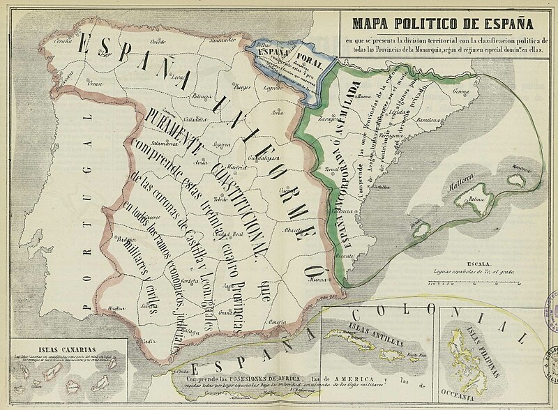
Text on the map
Top (Title)
«Mapa de España en que se presenta la división territorial con la clasificación de todas las Provincias de la Monarquía según el régimen legal especial común en ellos».
Orange-surrounded area
«España Uniforme ó Puramente Constitucional que comprende estas treinta y cuatro Provincias de las coronas de Castilla y León, iguales en todos los ramos económicos, judiciales, militares y civiles».
Former kingdoms of Castile, León and Granada.
Green-surrounded area
«España Incorporada ó Asimilada que comprende las once provincias de la Corona de Aragón, todavía diferentes en el modo de contribuir y en algunos puntos del derecho privado».
Crown of Aragón
Blue-surrounded area
«España Foral».
Navarre and the Provincias Vascongadas
Overseas
«España Colonial».
|
Detta verk är också upphovsrättsfritt i länder och områden där upphovsrätten förfaller 70 år eller färre efter upphovsmannens död.
| |
| Denna fil har identifierats som fri från kända begränsningar enligt upphovsrätten, inklusive alla relaterade och närliggande rättigheter. | |
Filhistorik
Klicka på ett datum/klockslag för att se filen som den såg ut då.
| Datum/Tid | Miniatyrbild | Dimensioner | Användare | Kommentar | |
|---|---|---|---|---|---|
| nuvarande | 23 november 2012 kl. 12.52 | | 1 800 × 1 322 (399 kbyte) | Ivan bea | Better resolution image of the same file |
| 4 augusti 2006 kl. 18.23 |  | 800 × 595 (98 kbyte) | Dodo | Political map of Spain in 1854 after the First Carlist War and the tax, legal system and military frontiers move to the Pyrenees, which resulted in the spreading of a sense of frustration among the Basques that led to another Carlist war and the subsequen |
Filanvändning
Följande 2 sidor använder den här filen:
Global filanvändning
Följande andra wikier använder denna fil:
- Användande på an.wikipedia.org
- Användande på ar.wikipedia.org
- Användande på azb.wikipedia.org
- Användande på ca.wikipedia.org
- Espanya
- Història del País Valencià
- Corona d'Aragó
- Furs
- Espanyolisme
- Diada Nacional de Catalunya
- Anticatalanisme
- Nacionalitat històrica
- Cronologia de la repressió del català
- Sexenni Democràtic
- Història del nacionalisme basc
- Diada del 25 d'abril
- Estat nació
- Història de l'Aragó
- Regionalisme i nacionalisme a Espanya
- Història del País Basc
- Usuari:Coentor/25
- Història de l'organització territorial del poder a Espanya
- Användande på de.wikipedia.org
- Användande på en.wikipedia.org
- Catalan language
- History of Europe
- Nation state
- Fuero
- Catalan independence movement
- First Carlist War
- User:Idiazabal
- History of the Basques
- 1833 territorial division of Spain
- Communities of chartered regime
- End of Basque home rule in Spain
- User:Ixtal/sandbox
- History of the territorial organization of Spain
- Användande på eo.wikipedia.org
- Användande på es.wikipedia.org
- Vasco
- Corona de Aragón
- Fuero
- Historia de la organización territorial de España
- Régimen foral
- Formación territorial de España
- Discusión:Corona de Castilla
- Historia del País Vasco
- Historia del nacionalismo vasco
- Euskal Herria como proyecto político
- Ley de 21 de julio de 1876
- Ley de Confirmación de Fueros de 1839
- Användande på eu.wikipedia.org
Visa mer globalt användande av denna fil.