Fil:Liverpool Bay.png

Storlek på förhandsvisningen: 800 × 593 pixlar. Andra upplösningar: 320 × 237 pixlar | 640 × 474 pixlar | 1 024 × 759 pixlar | 1 278 × 947 pixlar.
Originalfil (1 278 × 947 pixlar, filstorlek: 1,84 Mbyte, MIME-typ: image/png)
| Denna fil tillhandahålls av Wikimedia Commons. Informationen nedan är kopierad från dess filbeskrivningssida. |
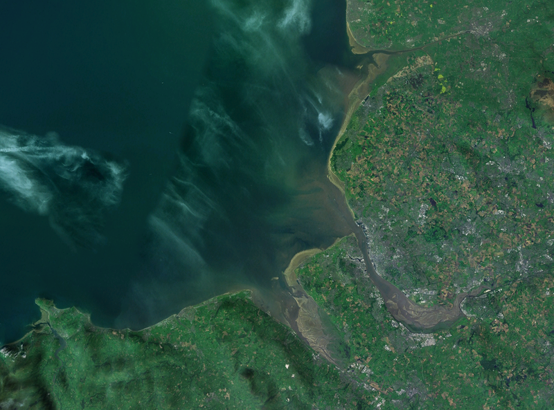
| Beskrivning | A satellite photograph of Liverpool Bay, showing the West Lancashire Coastal Plain River Ribble at the top (north), the River Alt (hardly visble), River Mersey (centre) River Dee and the River Conwy in the south west. |
| Datum | |
| Källa | NASA World Wind - Landsat 7 |
| Skapare | Smurrayinchester |
| This image is in the public domain because it is a screenshot from NASA’s globe software World Wind using a public domain layer, such as Blue Marble, MODIS, Landsat, SRTM, USGS or GLOBE.
|
 |
| Kameraposition | | Se denna och andra närliggande bilder på: OpenStreetMap |
|---|

Filhistorik
Klicka på ett datum/klockslag för att se filen som den såg ut då.
| Datum/Tid | Miniatyrbild | Dimensioner | Användare | Kommentar | |
|---|---|---|---|---|---|
| nuvarande | 28 april 2007 kl. 16.06 | | 1 278 × 947 (1,84 Mbyte) | Smurrayinchester | {{Information |Description=A satellite photograph of w:Liverpool Bay, showing the Rivers Dee and Mersey (centre), the River Alt (north) and the River Conwy (west). |Source=NASA World Wind - Landsat 7 |Date=28 April 2007 |Author= [[User:Smurrayincheste |
Filanvändning
Följande sida använder den här filen:
Global filanvändning
Följande andra wikier använder denna fil:
- Användande på ca.wikipedia.org
- Användande på ceb.wikipedia.org
- Användande på cy.wikipedia.org
- Användande på en.wikipedia.org
- Användande på eo.wikipedia.org
- Användande på es.wikipedia.org
- Användande på et.wikipedia.org
- Användande på it.wikipedia.org
- Användande på nl.wikipedia.org
- Användande på nn.wikipedia.org
- Användande på no.wikipedia.org
- Användande på pl.wikipedia.org
- Användande på pl.wiktionary.org
- Användande på ru.wikipedia.org
- Användande på sr.wikipedia.org
- Användande på vi.wikipedia.org
- Användande på www.wikidata.org