Fil:Illinois District 4 2004.png
Det finns ingen version med högre upplösning.
Illinois_District_4_2004.png (380 × 379 pixlar, filstorlek: 13 kbyte, MIME-typ: image/png)
| Denna fil tillhandahålls av Wikimedia Commons. Informationen nedan är kopierad från dess filbeskrivningssida. |
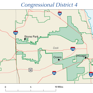
Illinois' 4th Congressional District, 108th Congress
Illustrates gerrymandering.
This map was obtained from an edition of the National Atlas of the United States. Like almost all works of the U.S. federal government, works from the National Atlas are in the public domain in the United States.
Online access: NationalAtlas.gov | 1970 print edition: Library of Congress, Perry-Castañeda Library
|
Filhistorik
Klicka på ett datum/klockslag för att se filen som den såg ut då.
| Datum/Tid | Miniatyrbild | Dimensioner | Användare | Kommentar | |
|---|---|---|---|---|---|
| nuvarande | 26 juli 2005 kl. 11.03 | | 380 × 379 (13 kbyte) | Scott Ritchie | Illinois' 4th Congressional District, 108th Congress {{PD-self}} |
Filanvändning
Följande sida använder den här filen:
Global filanvändning
Följande andra wikier använder denna fil:
- Användande på en.wikipedia.org
- Användande på eo.wikipedia.org
- Användande på es.wikipedia.org
- Användande på fr.wikipedia.org
- Användande på ja.wikipedia.org
- Användande på no.wikipedia.org
- Användande på pt.wikipedia.org
- Användande på www.wikidata.org
- Användande på zh.wikipedia.org