Fil:Granger Stage Station.jpg

Storlek på förhandsvisningen: 800 × 559 pixlar. Andra upplösningar: 320 × 224 pixlar | 640 × 447 pixlar | 956 × 668 pixlar.
Originalfil (956 × 668 pixlar, filstorlek: 73 kbyte, MIME-typ: image/jpeg)
| Denna fil tillhandahålls av Wikimedia Commons. Informationen nedan är kopierad från dess filbeskrivningssida. |
|
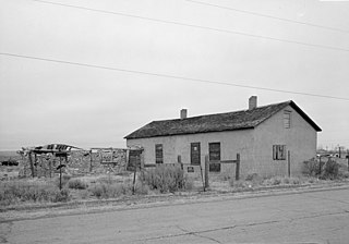
This is an image of a place or building that is listed on the National Register of Historic Places in the United States of America. Its reference number is 70000678. |
| Kameraposition | | Se denna och andra närliggande bilder på: OpenStreetMap |
|---|
| Beskrivning |
English: Front of the Granger Station, a former stagecoach station located along Old U.S. Route 30 in Granger, Wyoming, United States. Built in 1856, the station is listed on the National Register of Historic Places. |
|||||
| Datum | Okänt datum | |||||
| Källa | Library of Congress, Prints and Photograph Division HABS: WYO,19-GRANG,1-1 | |||||
| Skapare | Okänd | |||||
| Tillstånd (Återanvändning av denna fil) |
|


|
This image is available from the United States Library of Congress's Prints and Photographs division
under the digital ID hhh.wy0029. This tag does not indicate the copyright status of the attached work. A normal copyright tag is still required. See Commons:Licensing.
|
Filhistorik
Klicka på ett datum/klockslag för att se filen som den såg ut då.
| Datum/Tid | Miniatyrbild | Dimensioner | Användare | Kommentar | |
|---|---|---|---|---|---|
| nuvarande | 28 april 2009 kl. 20.20 | | 956 × 668 (73 kbyte) | Cropbot | upload cropped version, operated by User:Finavon. Summary: border cropped |
| 25 april 2009 kl. 17.32 |  | 1 024 × 728 (83 kbyte) | Nyttend | {{Location|41|35|25|N|109|58|8|W}} {{Information |Description={{en|Front of the {{w|Granger Station}}, a former {{w|stagecoach}} station located along Old {{w|U.S. Route 30}} in {{w|Granger, Wyoming|Granger}}, {{w|Wyoming}}, {{w|United States}}. Built in |
Filanvändning
Följande sida använder den här filen:
Global filanvändning
Följande andra wikier använder denna fil:
- Användande på azb.wikipedia.org
- Användande på de.wikipedia.org
- Användande på en.wikipedia.org
- Användande på fa.wikipedia.org
- Användande på pt.wikipedia.org
- Användande på sh.wikipedia.org
- Användande på sr.wikipedia.org
- Användande på uk.wikipedia.org
- Användande på zh-min-nan.wikipedia.org