Fil:FrontLines Environment Photo Contest Winner -5 (5808476109).jpg
.jpg)
.jpg&action=edit&redlink=1)
Storlek på förhandsvisningen: 800 × 534 pixlar. Andra upplösningar: 320 × 214 pixlar | 640 × 427 pixlar | 1 024 × 683 pixlar | 1 280 × 854 pixlar.
Originalfil (1 280 × 854 pixlar, filstorlek: 432 kbyte, MIME-typ: image/jpeg)
| Denna fil tillhandahålls av Wikimedia Commons. Informationen nedan är kopierad från dess filbeskrivningssida. |
.jpg)
Sammanfattning
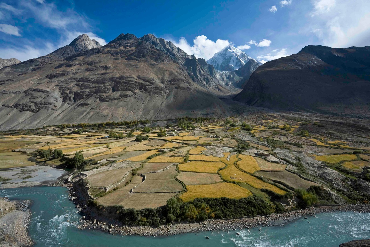
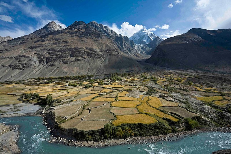
| Beskrivning | Here, a dramatic view of flood plain cultivation in Wakhan, Afghanistan. Known as "the roof of the world," the Wildlife Conservation Society says the Wakhan Corridor has few rivals in terms of scenic beauty. The little-known area is nestled in the high Pamir Mountains and the region is flanked by the Hindu Kush, Himalayn, Karakoram, and Kunlun ranges. Credit: John Winnie Jr., WCS-Afghanistan |
| Datum | |
| Källa | FrontLines Environment Photo Contest Winner #5 |
| Skapare | USAID U.S. Agency for International Development |
| Kameraposition | | Se denna och andra närliggande bilder på: OpenStreetMap |
|---|
.jpg¶ms=036.952778_N_0072.962500_E_globe:Earth_type:camera__&language=sv)
| Objektposition | | Se denna och andra närliggande bilder på: OpenStreetMap |
|---|
.jpg¶ms=036.951111_N_0072.962778_E_globe:Earth_class:object_type:object__&language=sv)
The geographical information in this file was retrospectively estimated.
The location may therefore be somewhat imprecise. Verifying and refining these coordinates is strongly encouraged. |
- Notes on location estimate
- Identify village by shape of the farm field
Licensiering
This image is a work of a United States Agency for International Development employee, taken or made as part of that person's official duties. As a work of the U.S. federal government, the image is in the public domain in the United States.
See also: The USAID privacy policy and the USAID Office of Inspector General "Disclaimers & Notices" page
|
 |
| Denna bild laddades ursprungligen upp på Flickr av USAID_IMAGES på https://flickr.com/photos/46658241@N06/5808476109. 4 januari 2017 granskades den av roboten FlickreviewR och befanns vara licensierad under licensen United States Government Work. |
Filhistorik
Klicka på ett datum/klockslag för att se filen som den såg ut då.
| Datum/Tid | Miniatyrbild | Dimensioner | Användare | Kommentar | |
|---|---|---|---|---|---|
| nuvarande | 4 januari 2017 kl. 04.06 | | 1 280 × 854 (432 kbyte) | Reguyla | Transferred from Flickr via Flickr2Commons |
Filanvändning
Följande sida använder den här filen:
Global filanvändning
Följande andra wikier använder denna fil:
- Användande på arz.wikipedia.org
- Användande på be.wikipedia.org
- Användande på bg.wikipedia.org
- Användande på ca.wikipedia.org
- Användande på ceb.wikipedia.org
- Användande på cs.wikipedia.org
- Användande på de.wikipedia.org
- Användande på de.wikivoyage.org
- Användande på el.wikipedia.org
- Användande på en.wikipedia.org
- Användande på en.wikivoyage.org
- Användande på eo.wikipedia.org
- Användande på es.wikipedia.org
- Användande på eu.wikipedia.org
- Användande på fa.wikipedia.org
- Användande på he.wikivoyage.org
- Användande på ja.wikipedia.org
- Användande på pl.wikipedia.org
- Användande på pl.wiktionary.org
- Användande på ru.wikipedia.org
- Användande på ru.wikinews.org
- Användande på ta.wikipedia.org
- Användande på uk.wikipedia.org
- Användande på ur.wikipedia.org
- Användande på www.wikidata.org
- Användande på zh.wikipedia.org
.jpg)