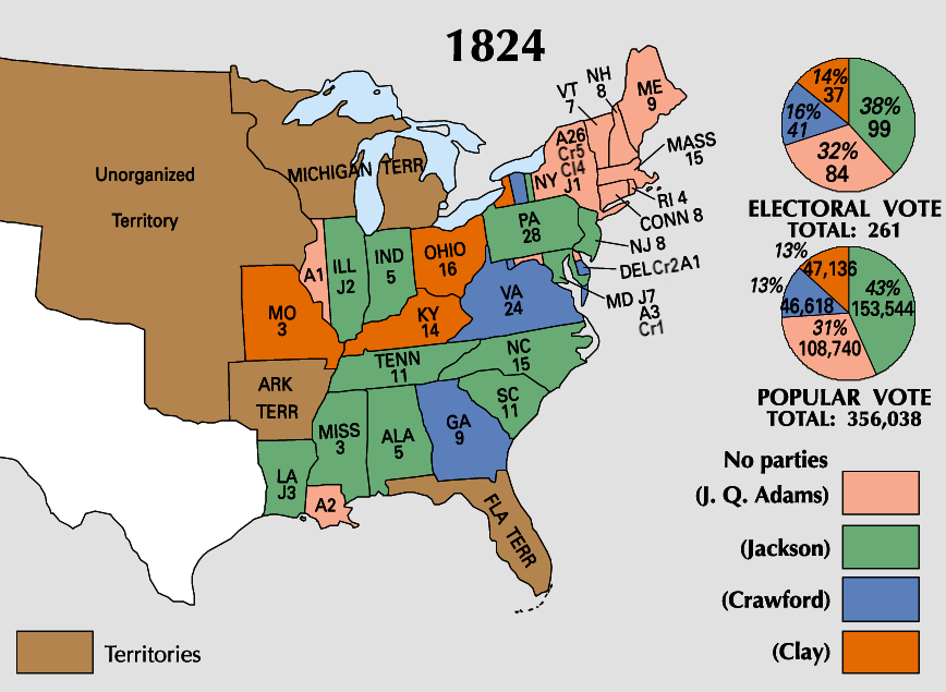
Fil:ElectoralCollege1824-Large.png
Storlek på förhandsvisningen: 800 × 585 pixlar. Andra upplösningar: 320 × 234 pixlar | 640 × 468 pixlar | 868 × 635 pixlar.
Originalfil (868 × 635 pixlar, filstorlek: 115 kbyte, MIME-typ: image/png)
| Denna fil tillhandahålls av Wikimedia Commons. Informationen nedan är kopierad från dess filbeskrivningssida. |
| U.S. presidential election maps from the National Atlas of the United States |
| See also: SVG maps |
| 1789 · 1792 · 1796 · 1800 · 1804 · 1808 · 1812 · 1816 · 1820 · 1824 · 1828 · 1832 · 1836 · 1840 · 1844 · 1848 · 1852 · 1856 · 1860 · 1864 · 1868 · 1872 · 1876 · 1880 · 1884 · 1888 · 1892 · 1896 · 1900 · 1904 · 1908 · 1912 · 1916 · 1920 · 1924 · 1928 · 1932 · 1936 · 1940 · 1944 · 1948 · 1952 · 1956 · 1960 · 1964 · 1968 · 1972 · 1976 · 1980 · 1984 · 1988 · 1992 · 1996 · 2000 · 2004 |
Sammanfattning
| Beskrivning | |
| Källa | https://nationalmap.gov/small_scale/printable/elections.html |
| Skapare | United States Geological Survey |
Licensiering
This map was obtained from an edition of the National Atlas of the United States. Like almost all works of the U.S. federal government, works from the National Atlas are in the public domain in the United States.
Online access: NationalAtlas.gov | 1970 print edition: Library of Congress, Perry-Castañeda Library
|
Filhistorik
Klicka på ett datum/klockslag för att se filen som den såg ut då.
| Datum/Tid | Miniatyrbild | Dimensioner | Användare | Kommentar | |
|---|---|---|---|---|---|
| nuvarande | 19 juni 2023 kl. 22.57 | | 868 × 635 (115 kbyte) | Rogl94 | Corrected Clay number in New York from 14 to 4, distinguished more between Crawford and Clay |
| 22 januari 2006 kl. 20.01 |  | 868 × 635 (83 kbyte) | Red devil 666 | {{PD-USGov-Atlas}} |
Filanvändning
Följande sida använder den här filen:
Global filanvändning
Följande andra wikier använder denna fil:
- Användande på en.wikipedia.org
- Användande på ja.wikipedia.org
- Användande på nl.wikipedia.org
- Användande på no.wikipedia.org
- Användande på ru.wikipedia.org
- Användande på tr.wikipedia.org
- Användande på uk.wikipedia.org
- Användande på vi.wikipedia.org
- Användande på www.wikidata.org
- Användande på zh.wikipedia.org