Fil:Dighton Rock-Davis photograph.jpg
Originalfil (1 858 × 1 270 pixlar, filstorlek: 1 Mbyte, MIME-typ: image/jpeg)
| Denna fil tillhandahålls av Wikimedia Commons. Informationen nedan är kopierad från dess filbeskrivningssida. |
|
This is an image of a place or building that is listed on the National Register of Historic Places in the United States of America. Its reference number is 80000438. |
| Beskrivning |
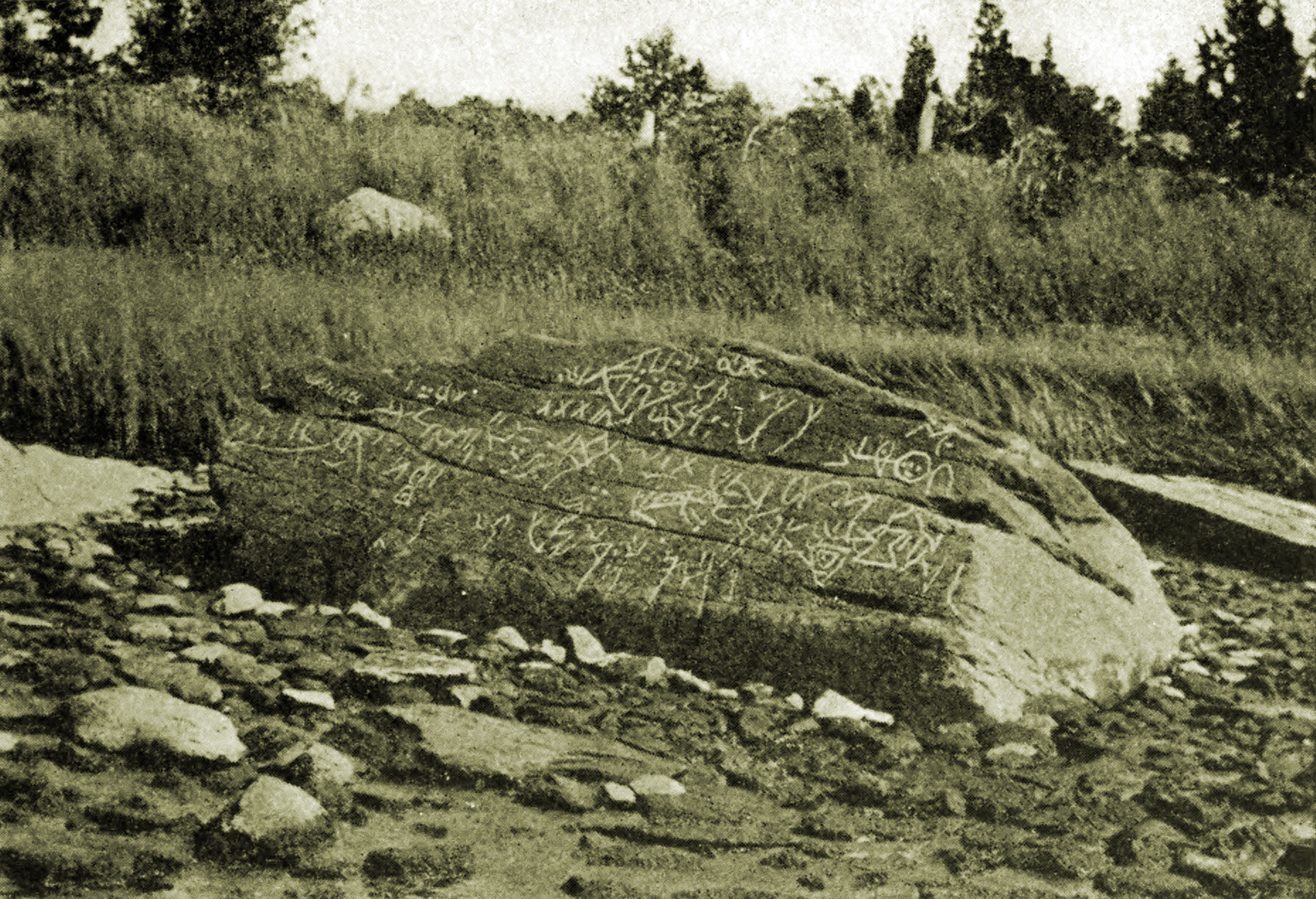
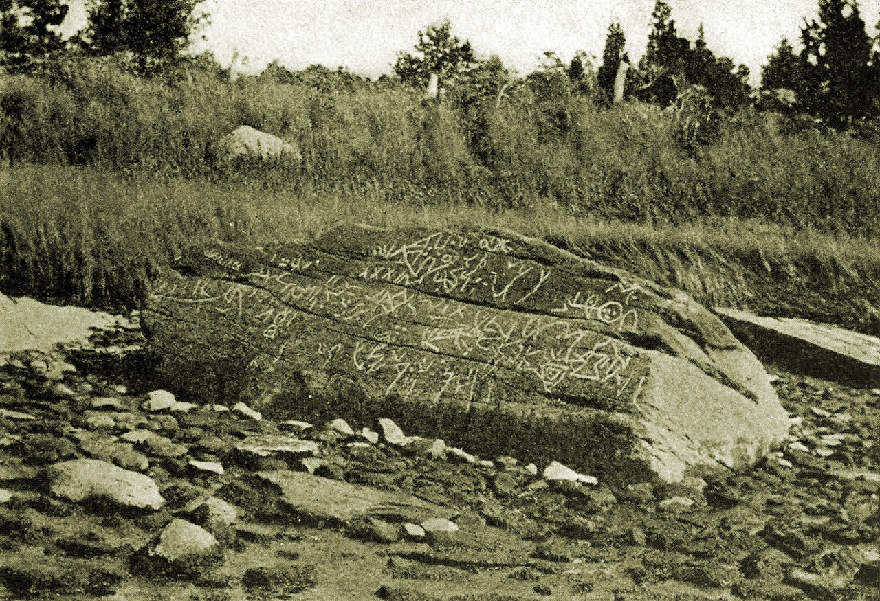
Photograph by Frank S. Davis, September 11. The author stated: " One of them is dated September 11, 1893; the other two were taken the winter following. I do not remember to have copied any previous photographs or drawings in making my markings on the rock. Going back to my school days, I can remember going to the rock and taking chalk and marking in the lines. There would be a number of us and we would all work at it and talk about what they were put there for. So you see I had seen the lines marked in a good many times. Then in after years I got a camera and got quite interested in taking pictures. One of the photographs I made for some one who was writing a book at that time, but cannot remember the name of the writer or that of the book. I expect that I marked quite a few lines on the rock which were never put on by the maker; also that there were quite a few marks put on by the maker which I did not mark in. The rock was so worn away that it was very hard to trace the markings, and not knowing what the figures were one had to use his own ideas in connecting the markings. You will notice the one taken in September is not as complete as the one taken later; possibly it is nearer right than the one taken the following winter which I tried to fill in more. The marks low down on the photo I do not think amount to much." source |
| Datum | |
| Källa | Recent history of Dighton Rock by Edmund Burke Delabarre, 1919. Reprinted from the publications of The Colonial Society of Massachusetts, Volume XX Other sources: U.S. History Images, slide 3888, Publications of The Colonial Society of Massachusetts, Volume XX, TRANSACTIONS 1917–1919. |
| Skapare | Frank S. Davis |
| Tillstånd (Återanvändning av denna fil) |
public domain |
| Objektposition | | Se denna och andra närliggande bilder på: OpenStreetMap |
|---|
|
Detta verk är också upphovsrättsfritt i länder och områden där upphovsrätten förfaller 70 år eller färre efter upphovsmannens död.
| |
| Denna fil har identifierats som fri från kända begränsningar enligt upphovsrätten, inklusive alla relaterade och närliggande rättigheter. | |
Filhistorik
Klicka på ett datum/klockslag för att se filen som den såg ut då.
| Datum/Tid | Miniatyrbild | Dimensioner | Användare | Kommentar | |
|---|---|---|---|---|---|
| nuvarande | 16 juni 2022 kl. 12.17 | | 1 858 × 1 270 (1 Mbyte) | Sette-quattro | removed moire effect |
| 4 april 2020 kl. 15.58 |  | 1 858 × 1 270 (1,24 Mbyte) | Sette-quattro | image taken form scan of original book | |
| 19 december 2015 kl. 00.53 |  | 1 070 × 735 (325 kbyte) | Bogomolov.PL | more contrast | |
| 20 september 2006 kl. 05.51 |  | 1 070 × 735 (276 kbyte) | Gribeco | {{Information |Description=Photograph of the Dighton Rock taken by Davis in 1893 |Source=http://historyproject.ucdavis.edu/khapp.php?SlideNum=3888 |Date=1893 |Author=uploaded by Kimon Berlin, user:Gribeco |Permission=public domain |other_versions= }} |
Filanvändning
Följande sida använder den här filen:
Global filanvändning
Följande andra wikier använder denna fil:
- Användande på ar.wikipedia.org
- Användande på de.wikipedia.org
- Användande på en.wikipedia.org
- Användande på es.wikipedia.org
- Användande på fr.wikipedia.org
- Användande på hr.wikipedia.org
- Användande på hy.wikipedia.org
- Användande på hyw.wikipedia.org
- Användande på it.wikipedia.org
- Användande på pl.wikipedia.org
- Användande på pt.wikipedia.org
- Användande på ru.wikipedia.org
- Användande på sh.wikipedia.org
- Användande på uk.wikipedia.org
- Användande på www.wikidata.org