Fil:Chquel-map-fr.png
Det finns ingen version med högre upplösning.
Chquel-map-fr.png (348 × 352 pixlar, filstorlek: 145 kbyte, MIME-typ: image/png)
| Denna fil tillhandahålls av Wikimedia Commons. Informationen nedan är kopierad från dess filbeskrivningssida. |
Sammanfattning
| Kameraposition | | Se denna och andra närliggande bilder på: OpenStreetMap |
|---|
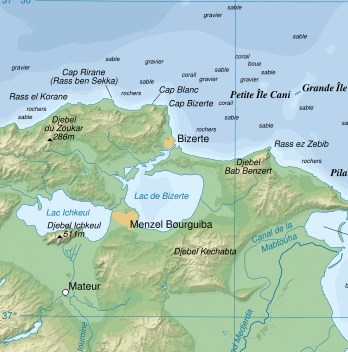
| Beskrivning | Topographic map in French of the Gulf of Tunis, Tunisia, with indication of the nature of the sea bottom |
| Datum | |
| Källa |
Own work ; Topographic map : NASA Shuttle Radar Topography Mission (SRTM3 v.2) (public domain) edited with dlgv32 Pro and vectorized with Inkscape ; UTM projection ; WGS84 datum ; shaded relief (composite image of N-W, W and N lightning positions) ; References used for bathymetry and additional data : * 1:250,000 U.S. Army maps (printed 1956) ; * Google Earth ; * Locator map : Image:Tunisia.svg (modified) created by Philip Ronan (in PD) Approximate scale of topographic data and shore / lakes limits : 1:372,000 ; Note : The shaded relief is a raster image embedded in the SVG file which increases its size. If you want a lighter map for other purposes, delete the shaded relief image in your file. |
| Skapare | Eric Gaba (Sting) |
| Tillstånd (Återanvändning av denna fil) |
Attribution and Share-Alike required |
base source: http://commons.wikimedia.org/wiki/Image:Tunis_Gulf_topo_map-fr.svg
Français : * Sujet : Carte topographique en français du Golfe de Tunis, avec indication de la nature des fonds marins ;
- Sources : Création personnelle
- Données topographiques : NASA Shuttle Radar Topography Mission (SRTM3 v.2) (domaine public) édité avec dlgv32 Pro et vectorisé avec Inkscape ; projection UTM ; WGS84 datum ; relief ombré (image composite d'éclairages du N-O, O et N) ;
- Références utilisées pour la bathymétrie et les données complémentaires :
- Cartes au 1:250 000e de l'U.S. Army (imprimées en 1956) ;
- Google Earth ;
- Carte de localisation : Image:Tunisia.svg (modifiée) créée par Philip Ronan dans le domaine public ;
- Échelle approximative : 1:372 000 (données topographiques et tracés des côtes / lacs) ;
- Note : Le relief ombré est une image bitmap encapsulée dans le fichier SVG qui augmente son poids. Si vous avez besoin d'une carte plus légère pour d'autres utilisations, supprimez l'image du relief ombré dans votre fichier ;
- Auteur : Eric Gaba (fr:Sting) ;
- Date : Octobre 2007.
Licensiering
Jag, upphovsrättsinnehavaren av detta verk, publicerar härmed det under följande licenser:

|
Tillstånd ges att kopiera, distribuera och/eller modifiera detta dokument under villkoren i GNU Free Documentation License, Version 1.2 eller senare version publicerad av Free Software Foundation, utan oföränderliga avsnitt, framsidestexter eller baksidestexter. En kopia av licensen ingår i avsnittet GNU Free Documentation License. |
Denna fil har gjorts tillgänglig under licenserna Creative Commons Erkännande-DelaLika 3.0 Unported, 2.5 Generisk, 2.0 Generisk och 1.0 Generisk.
- Du är fri:
- att dela – att kopiera, distribuera och sända verket
- att remixa – att skapa bearbetningar
- På följande villkor:
- erkännande – Du måste ge lämpligt erkännande, ange en länk till licensen och indikera om ändringar har gjorts. Du får göra det på ett lämpligt sätt, men inte på ett sätt som antyder att licensgivaren stödjer dig eller din användning.
- dela lika – Om du remixar, transformerar eller bygger vidare på materialet måste du distribuera dina bidrag under samma eller en kompatibel licens som originalet.
Du får själv välja den licens du vill använda.
Filhistorik
Klicka på ett datum/klockslag för att se filen som den såg ut då.
| Datum/Tid | Miniatyrbild | Dimensioner | Användare | Kommentar | |
|---|---|---|---|---|---|
| nuvarande | 17 juli 2008 kl. 02.18 | | 348 × 352 (145 kbyte) | Ori~ | {{Information |Description= |Source= |Date= |Author= |Permission= |other_versions= }} |
| 17 juli 2008 kl. 02.16 |  | 849 × 768 (699 kbyte) | Ori~ | base source: http://commons.wikimedia.org/wiki/Image:Tunis_Gulf_topo_map-fr.svg == Summary == {{Location|37|00|00|N|10|30|00|E|scale:500000}} {{Information |Description=Topographic map in French of the Gulf of Tunis, Tunisia, with i |
Filanvändning
Följande sida använder den här filen:
Global filanvändning
Följande andra wikier använder denna fil:
- Användande på et.wikipedia.org
- Användande på he.wikipedia.org
- Användande på lv.wikipedia.org