Fil:Chad sat.jpg

Storlek på förhandsvisningen: 394 × 599 pixlar. Andra upplösningar: 158 × 240 pixlar | 316 × 480 pixlar | 505 × 768 pixlar | 1 265 × 1 922 pixlar.
Originalfil (1 265 × 1 922 pixlar, filstorlek: 1,79 Mbyte, MIME-typ: image/jpeg)
| Denna fil tillhandahålls av Wikimedia Commons. Informationen nedan är kopierad från dess filbeskrivningssida. |
Sammanfattning
| Beskrivning |
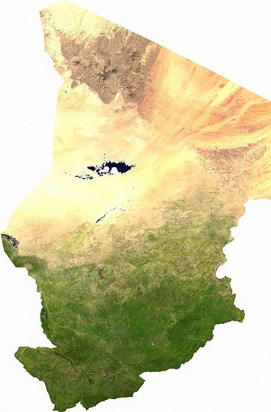
Español: Mapa satelital de Chad, se puede apreciar el contraste entre la zona árida del norte, que corresponde al sur del Sahara; y la zona fértil del sur.
Los musulmanes del norte piden privilegios económicos.
|
| Datum | |
| Källa | user |
| Skapare | Cwolfsheep |
Licensiering
| This file is in the public domain, because it was generated by a user, using free sources available at The Map Library.
Note that this does not include the maps in the Global Administrative Areas section of the homepage. |
Filhistorik
Klicka på ett datum/klockslag för att se filen som den såg ut då.
| Datum/Tid | Miniatyrbild | Dimensioner | Användare | Kommentar | |
|---|---|---|---|---|---|
| nuvarande | 13 juli 2006 kl. 05.43 | | 1 265 × 1 922 (1,79 Mbyte) | Unquietwiki | ECW to TIFF to JPEG (100% quality; progressive formatting). {{PD-MapLibrary}} |
Filanvändning
Följande 5 sidor använder den här filen:
Global filanvändning
Följande andra wikier använder denna fil:
- Användande på af.wikipedia.org
- Användande på als.wikipedia.org
- Användande på ar.wikipedia.org
- Användande på bg.wikipedia.org
- Användande på bs.wikipedia.org
- Användande på ca.wikipedia.org
- Användande på da.wikipedia.org
- Tchad
- Tchads historie
- Wikipedia:Dagens skandinaviske artikel/september 2009
- Wikipedia:Dagens skandinaviske artikel/Svensk/Uge 36, 2009
- Wikipedia:Dagens skandinaviske artikel/august 2012
- Wikipedia:Dagens skandinaviske artikel/Bokmål/Uge 32, 2012
- Wikipedia:Dagens skandinaviske artikel/maj 2014
- Wikipedia:Dagens skandinaviske artikel/Søndag/Uge 20, 2014
- Användande på de.wikipedia.org
- Användande på de.wikiversity.org
- Användande på el.wikipedia.org
- Användande på en.wikipedia.org
- Användande på eo.wikipedia.org
- Användande på es.wikipedia.org
- Användande på eu.wikipedia.org
- Användande på fa.wikipedia.org
- Användande på fr.wikipedia.org
- Användande på hu.wikipedia.org
- Användande på ig.wikipedia.org
- Användande på is.wikipedia.org
- Användande på it.wikipedia.org
- Användande på ja.wikipedia.org
- Användande på ka.wikipedia.org
- Användande på kk.wikipedia.org
- Användande på li.wikipedia.org
- Användande på mn.wikipedia.org
- Användande på mt.wikipedia.org
- Användande på nn.wikipedia.org
- Användande på no.wikipedia.org
Visa mer globalt användande av denna fil.