Fil:Arthur 2008 track.png

Storlek på förhandsvisningen: 800 × 495 pixlar. Andra upplösningar: 320 × 198 pixlar | 640 × 396 pixlar | 1 024 × 633 pixlar | 1 280 × 791 pixlar | 2 700 × 1 669 pixlar.
Originalfil (2 700 × 1 669 pixlar, filstorlek: 2,92 Mbyte, MIME-typ: image/png)
| Denna fil tillhandahålls av Wikimedia Commons. Informationen nedan är kopierad från dess filbeskrivningssida. |
Sammanfattning
| Beskrivning |
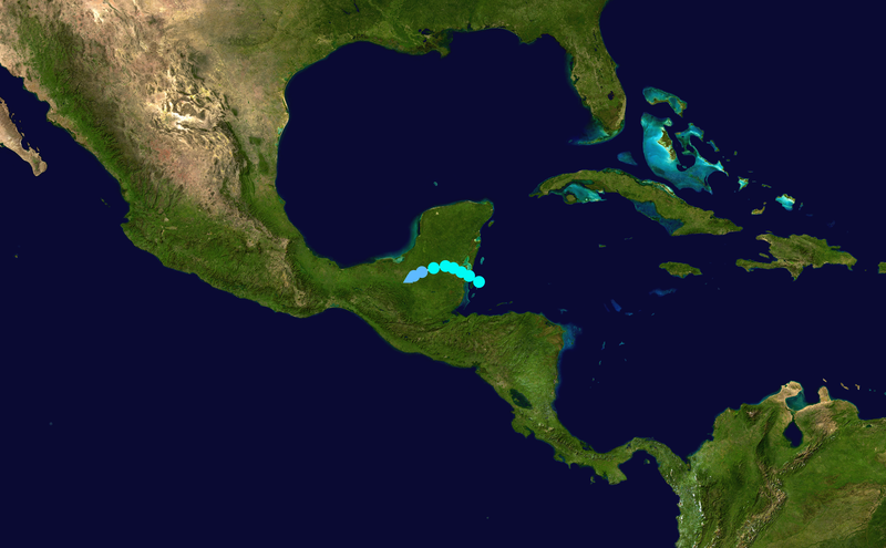
English: Track map of Tropical Storm Arthur of the 2008 Atlantic hurricane season. The points show the location of the storm at 6-hour intervals. The colour represents the storm's maximum sustained wind speeds as classified in the (see below), and the shape of the data points represent the nature of the storm, according to the legend below. Tropical depression (≤38 mph, ≤62 km/h)
Tropical storm (39–73 mph, 63–118 km/h)
Category 1 (74–95 mph, 119–153 km/h)
Category 2 (96–110 mph, 154–177 km/h)
Category 3 (111–129 mph, 178–208 km/h)
Category 4 (130–156 mph, 209–251 km/h)
Category 5 (≥157 mph, ≥252 km/h)
Unknown
Storm type |
||
| Datum | 2008-05-31–2008-06-02 | ||
| Källa | Created by Supportstorm using Wikipedia:WikiProject Tropical cyclones/Tracks. The background image is from NASA. Tracking data is from the National Hurricane Center[1]. | ||
| Skapare | Supportstorm | ||
| Source code | Track map data table, if present below, is in HURDAT2 or ATCF format. See format details in [2] and [3], respectively.
|
Licensiering
| Detta verk har gjorts tillgänglig som public domain av dess skapare, Supportstorm. Detta gäller globalt. I vissa länder kan detta inte vara juridiskt möjligt; i så fall: Supportstorm ger envar rätten att använda detta verk för alla ändamål, utan några villkor, förutom villkor som lagen ställer. |
Filhistorik
Klicka på ett datum/klockslag för att se filen som den såg ut då.
| Datum/Tid | Miniatyrbild | Dimensioner | Användare | Kommentar | |
|---|---|---|---|---|---|
| nuvarande | 18 augusti 2019 kl. 09.32 | | 2 700 × 1 669 (2,92 Mbyte) | Supportstorm | Correction from HURDAT |
| 13 mars 2009 kl. 22.58 |  | 1 024 × 633 (477 kbyte) | Potapych | fix a slight error | |
| 18 december 2008 kl. 00.54 |  | 1 024 × 633 (497 kbyte) | Potapych | generated with track program | |
| 30 juli 2008 kl. 03.06 |  | 707 × 397 (261 kbyte) | CWY2190 | New image with smaller shapes. | |
| 30 juli 2008 kl. 02.39 |  | 800 × 487 (334 kbyte) | CWY2190 | Arthur best track | |
| 10 juli 2008 kl. 01.05 |  | 1 000 × 629 (457 kbyte) | CWY2190 | adding four low pressure areas | |
| 10 juli 2008 kl. 00.30 |  | 1 000 × 629 (457 kbyte) | CWY2190 | Track map of Tropical Storm Arthur of the 2008 Atlantic hurricane season. The background image is from {{w|NASA}}. Tracking data is from the [ftp://ftp.tpc.ncep.noaa.gov/atcf/tcweb/invest_al012008.invest|Natio | |
| 10 juli 2008 kl. 00.30 |  | 1 000 × 629 (457 kbyte) | CWY2190 | Track map of Tropical Storm Arthur of the 2008 Atlantic hurricane season. The background image is from {{w|NASA}}. Tracking data is from the [ftp://ftp.tpc.ncep.noaa.gov/atcf/tcweb/invest_al012008.invest|Natio | |
| 2 juni 2008 kl. 20.43 |  | 1 024 × 636 (25 kbyte) | Ramisses | {{Information |Description={{en|1=Tropical Storm Arthur (2008) track map}} |Source=Own work by uploader |Author=Ramisses |Date=2008-06-02 |Permission={{PD-self}} |other_versions= }} {{ImageUpload|full}} [[Category:Tropical Storm Arthur |
Filanvändning
Följande sida använder den här filen:
Global filanvändning
Följande andra wikier använder denna fil:
- Användande på cs.wikipedia.org
- Användande på de.wikipedia.org
- Användande på en.wikipedia.org
- Användande på es.wikipedia.org
- Användande på eu.wikipedia.org
- Användande på fr.wikipedia.org
- Användande på ko.wikipedia.org
- Användande på nl.wikipedia.org
- Användande på no.wikipedia.org
- Användande på pt.wikipedia.org
- Användande på ru.wikipedia.org
- Användande på simple.wikipedia.org
- Användande på uk.wikipedia.org
- Användande på www.wikidata.org
- Användande på zh.wikipedia.org