Fil:Anglo American War 1812 Locations map-en.svg

Originalfil (SVG-fil, standardstorlek: 1 052 × 744 pixlar, filstorlek: 136 kbyte)
| Denna fil tillhandahålls av Wikimedia Commons. Informationen nedan är kopierad från dess filbeskrivningssida. |
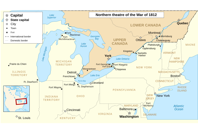
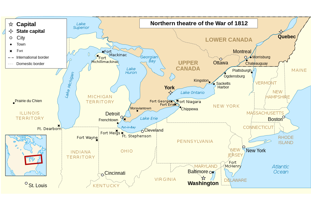
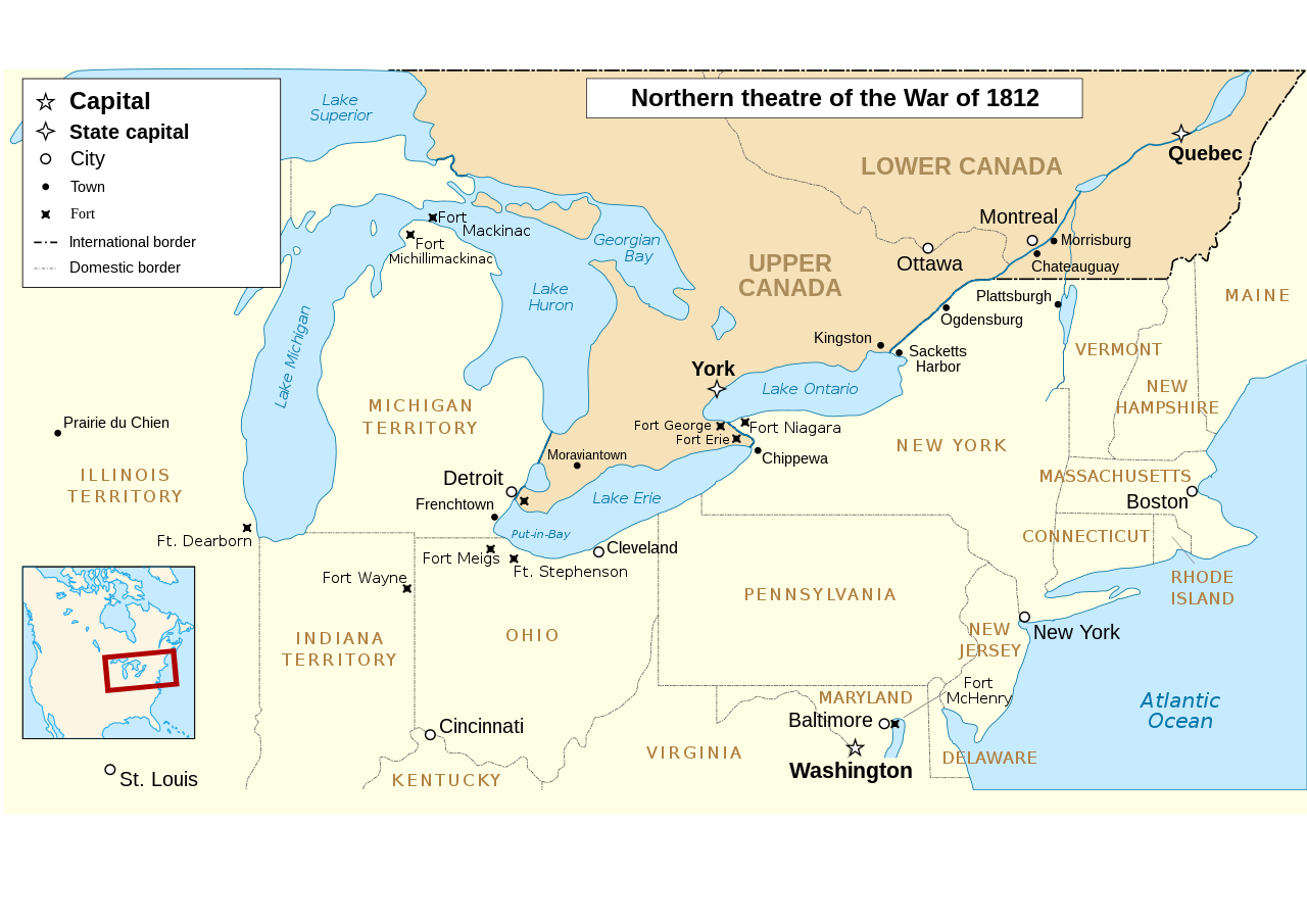
The map omits two of the most important battles of the war as far as the territorial outcome of the Treaty of Ghent. The Battle of Lake Erie (aka Battle of Put in Bay) was where the entire British Upper Great Lakes Fleet surrendered. With the Great Lakes supply lines cut, the British and their Indian allies destroyed the forts at Detroit and Amherstburg and tried to retreat up the Thames River hoping to reach the main British base at Burlington on Lake Ontario.The American army under General Harrison caught up with them at Moraviantown and the British were defeated. Most important was that Tecumseh was killed at this battle and, with his death, the Indian Confederation fell apart and thousands of the warriors just went home. When the Duke of Wellington, fresh from defeating Napoleon, was subsequently offered command of the British Army in America, he said he'd go but couldn't promise anything unless the Navy first got control of the Great Lakes. Otherwise, he told the negotiators that they may as well give up on any territorial demands and just make peace with the US. See "Three Strikes in the War of 1812".
| Beskrivning |
English: Main locations of the War of 1812 between the United States and the United Kingdom Français : Principaux théâtres d'opérations de la Guerre de 1812 entre les États-Unis et le Royaume-Uni. Español: Principales teatros de operaciones de la Guerra de 1812 entre los Estados Unidos y el Reino Unido. |
| Datum | (UTC) |
| Källa | |
| Skapare |
|
| Andra versioner |
Filer som bygger på denna fil: |
| Detta är en retuscherad eller på annat sätt behandlad bild, med vilket menas att den har redigerats digitalt från sitt original. Redigeringar: translated to english. Originalet kan ses här: Anglo American War 1812 Locations map-fr.svg. Redigeringar gjorda av P. S. Burton.
|
- Du är fri:
- att dela – att kopiera, distribuera och sända verket
- att remixa – att skapa bearbetningar
- På följande villkor:
- erkännande – Du måste ge lämpligt erkännande, ange en länk till licensen och indikera om ändringar har gjorts. Du får göra det på ett lämpligt sätt, men inte på ett sätt som antyder att licensgivaren stödjer dig eller din användning.
- dela lika – Om du remixar, transformerar eller bygger vidare på materialet måste du distribuera dina bidrag under samma eller en kompatibel licens som originalet.

|
Tillstånd ges att kopiera, distribuera och/eller modifiera detta dokument under villkoren i GNU Free Documentation License, Version 1.2 eller senare version publicerad av Free Software Foundation, utan oföränderliga avsnitt, framsidestexter eller baksidestexter. En kopia av licensen ingår i avsnittet GNU Free Documentation License. |
Ursprunglig uppladdningslogg
This image is a derivative work of the following images:
- File:Anglo_American_War_1812_Locations_map-fr.svg licensed with Cc-by-sa-3.0,2.5,2.0,1.0, GFDL
- 2008-06-20T23:26:18Z MaCRoEco 1494x830 (154198 Bytes) {{Information |Description= |Source= |Date= |Author= |Permission= |other_versions= }}
- 2008-06-17T16:04:43Z Sémhur 1494x830 (163461 Bytes) Mistake : Fort Henry => Fort McHenry
- 2008-06-17T09:50:41Z Sémhur 1494x830 (163245 Bytes) {{Information |Description={{en|1=Main locations of the [[:en:War of 1812|War of 1812]] between the United States and the United Kingdom}} {{fr|1=Principaux théâtres d'opérations de la [[:fr:Guerre de 1812|Guerre de 1812]]
Uploaded with derivativeFX
Filhistorik
Klicka på ett datum/klockslag för att se filen som den såg ut då.
| Datum/Tid | Miniatyrbild | Dimensioner | Användare | Kommentar | |
|---|---|---|---|---|---|
| nuvarande | 6 mars 2023 kl. 02.52 | | 1 052 × 744 (136 kbyte) | Hunter9502 | Reverted to version as of 08:55, 7 February 2021 (UTC) - February 2023 version has broken SVG formatting |
| 4 februari 2023 kl. 02.15 |  | 1 600 × 915 (493 kbyte) | Yourlocallordandsavior | Removed useless sections. | |
| 7 februari 2021 kl. 10.55 |  | 1 052 × 744 (136 kbyte) | Kevin1776 | Added requested missing locations (Moraviantown, Put-in-Bay), moved Fort Meigs to correct locations, other font & readability adjustments. | |
| 25 juli 2011 kl. 20.03 |  | 1 494 × 830 (128 kbyte) | Amirki | minor color change | |
| 22 januari 2011 kl. 23.05 |  | 1 494 × 830 (153 kbyte) | P. S. Burton | {{Information |Description={{en|1=Main locations of the War of 1812 between the United States and the United Kingdom}} {{fr|1=Principaux théâtres d'opérations de la Guerre de 1812 entre les États-Unis et le R |
Filanvändning
Följande sida använder den här filen:
Global filanvändning
Följande andra wikier använder denna fil:
- Användande på af.wikipedia.org
- Användande på de.wikipedia.org
- Användande på en.wikipedia.org
- Användande på gd.wikipedia.org
- Användande på he.wikipedia.org
- Användande på hr.wikipedia.org
- Användande på ro.wikipedia.org
- Användande på ru.wikipedia.org
- Användande på vi.wikipedia.org