Fil:1821 Atlantic Hurricane Track Map.png

Storlek på förhandsvisningen: 646 × 600 pixlar. Andra upplösningar: 259 × 240 pixlar | 517 × 480 pixlar | 681 × 632 pixlar.
Originalfil (681 × 632 pixlar, filstorlek: 15 kbyte, MIME-typ: image/png)
| Denna fil tillhandahålls av Wikimedia Commons. Informationen nedan är kopierad från dess filbeskrivningssida. |
| Beskrivning |
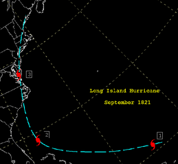
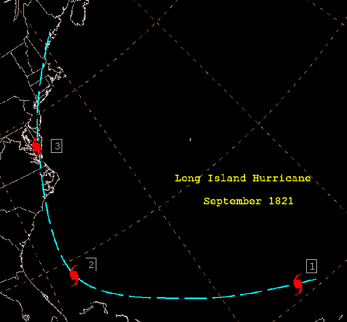
English: From http://www.wpc.ncep.noaa.gov/research/roth/sp1821.gif, this is a track map of the 1821 Norfolk and Long Island Hurricane. |
| Datum | 27 november 2005 (ursprungligt uppladdningsdatum) |
| Källa | Överförd från en.wikipedia till Commons. Transfer was stated to be made by User:bagster. |
| Skapare | The original uploader was Hurricanehink på engelska Wikipedia. |
Licensiering
- The NOAA emblem is the property of the U.S. Government and a trademark of the United States Department of Commerce.
This image is in the public domain because it contains materials that originally came from the U.S. National Oceanic and Atmospheric Administration, taken or made as part of an employee's official duties.
|
Ursprunglig uppladdningslogg
Den ursprungliga beskrivningssidan fanns här. Alla följande användarnamn finns på en.wikipedia.
- 2005-11-27 21:23 Hurricanehink 681×632×5 (8971 bytes) From http://www.wpc.ncep.noaa.gov/research/roth/sp1821.gif, this is a track map of the 1821 Norfolk and Long Island Hurricane. {{PD-USGov-NOAA}} {{NOAA logo}}
Ursprunglig uppladdningslogg
| Datum/Tid | Dimensioner | Användare | Kommentar |
|---|---|---|---|
| 3 december 2007, 01:33:40 | 681 × 632 (8971 bytes) | File Upload Bot (Magnus Manske) (diskussion · bidrag) | {{BotMoveToCommons|en.wikipedia}} {{Information |Description={{en|From http://www.hpc.ncep.noaa.gov/research/roth/sp1821.gif, this is a track map of the 1821 Norfolk and Long Island Hurricane.}} |Source=Transfered from [http://en.wikipedia.org en.wikiped |
Filhistorik
Klicka på ett datum/klockslag för att se filen som den såg ut då.
| Datum/Tid | Miniatyrbild | Dimensioner | Användare | Kommentar | |
|---|---|---|---|---|---|
| nuvarande | 8 augusti 2017 kl. 18.30 | | 681 × 632 (15 kbyte) | Beyond My Ken | Adjustments for visibility |
| 12 juli 2014 kl. 18.40 |  | 681 × 632 (11 kbyte) | GifTagger | Bot: Converting file to superior PNG file. (Source: 1821_Atlantic_Hurricane_Track_Map.gif). This GIF was problematic due to non-greyscale color table. |
Filanvändning
Följande sida använder den här filen:
Global filanvändning
Följande andra wikier använder denna fil:
- Användande på en.wikipedia.org
- Användande på www.wikidata.org