Fil:'Confederate General Lewis Armistead at The Angle' -- Gettysburg (PA) Cyclorama 2012.jpg
_Cyclorama_2012.jpg)
_Cyclorama_2012.jpg&action=edit&redlink=1)
Originalfil (2 397 × 1 379 pixlar, filstorlek: 703 kbyte, MIME-typ: image/jpeg)
| Denna fil tillhandahålls av Wikimedia Commons. Informationen nedan är kopierad från dess filbeskrivningssida. |
_Cyclorama_2012.jpg)
Sammanfattning
| Beskrivning |
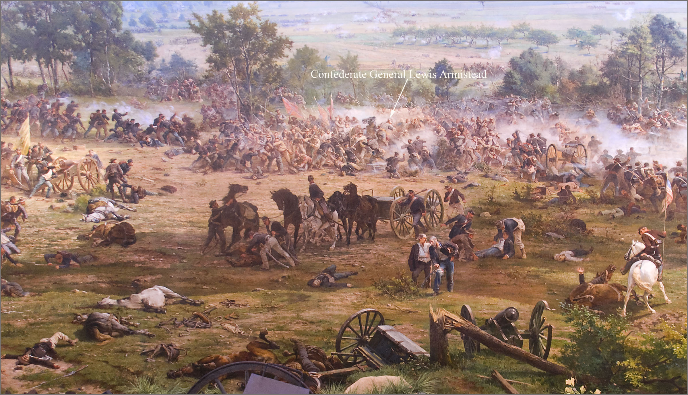
English: 'The Battle of Gettysburg', also known as the Gettysburg Cyclorama, is a cyclorama painting by the French artist Paul Philippoteaux depicting "Pickett's Charge", the climactic Confederate attack on the Union forces on Cemetery Ridge during the Battle of Gettysburg on Friday afternoon July 3, 1863.
The section of the Cyclorama shown above depicts Confederate General Lewis Armistead struck by rifle fire while leading his brigade in a break-through of the Union infantry line on Cemetery Ridge at an area known as "The Angle". Armistead's brigade arrived at Gettysburg on the evening of July 2nd. As part of the Pickett-Pettigrew Charge on the 3rd, Armistead led his brigade from the front on foot (not on a horse as portrayed above), waving his hat from the tip of his saber, and reaching and climbing over the stone wall at the "Angle", which served as the Charge's objective. Armistead was shot three times just after crossing the stone wall. However, his wounds were initially not believed to be mortal, being shot in the fleshy part of the arm and below the knee. He was eventually taken to a Union field hospital at the George Spangler Farm where he died two days later. The chief surgeon at the Union hospital there had expected Armistead to survive because he characterized the two bullet wounds as not serious. He wrote that the death "was not from his wounds directly, but from secondary fever and prostration". Image at 7:15 pm July 28, 2012, by Ron Cogswell using a hand-held Nikon D80 at 1/6 sec., f/3.5, ISO 400, and 18 mm, during an after-hours presentation on the Gettysburg Cyclorama conducted by Chris Brennaman. |
| Datum |
Painting:1883 Photograph: 2012-07-28 |
| Källa | https://www.flickr.com/photos/22711505@N05/7694930148/ |
| Skapare | Ron Cogswell |
| Kameraposition | | Se denna och andra närliggande bilder på: OpenStreetMap |
|---|
_Cyclorama_2012.jpg¶ms=039.811568_N_-077.226054_E_globe:Earth_type:camera__&language=sv)
Licensiering
| This image was originally posted to Flickr. Its license was verified as "cc-by-2.0" by the UploadWizard Extension at the time it was transferred to Commons. See the license information for further details. |
- Du är fri:
- att dela – att kopiera, distribuera och sända verket
- att remixa – att skapa bearbetningar
- På följande villkor:
- erkännande – Du måste ge lämpligt erkännande, ange en länk till licensen och indikera om ändringar har gjorts. Du får göra det på ett lämpligt sätt, men inte på ett sätt som antyder att licensgivaren stödjer dig eller din användning.
Filhistorik
Klicka på ett datum/klockslag för att se filen som den såg ut då.
| Datum/Tid | Miniatyrbild | Dimensioner | Användare | Kommentar | |
|---|---|---|---|---|---|
| nuvarande | 18 augusti 2013 kl. 04.38 | | 2 397 × 1 379 (703 kbyte) | Jarekt | User created page with UploadWizard |
Filanvändning
Följande sida använder den här filen:
Global filanvändning
Följande andra wikier använder denna fil:
- Användande på de.wikipedia.org
- Användande på en.wikipedia.org
- Användande på ja.wikipedia.org
- Användande på ru.wikipedia.org
_Cyclorama_2012.jpg)