Fil:Virgin islands national park map.png
Storlek på förhandsvisningen: 800 × 493 pixlar. Andra upplösningar: 320 × 197 pixlar | 640 × 394 pixlar | 1 024 × 630 pixlar | 1 629 × 1 003 pixlar.
Originalfil (1 629 × 1 003 pixlar, filstorlek: 515 kbyte, MIME-typ: image/png)
| Denna fil tillhandahålls av Wikimedia Commons. Informationen nedan är kopierad från dess filbeskrivningssida. |
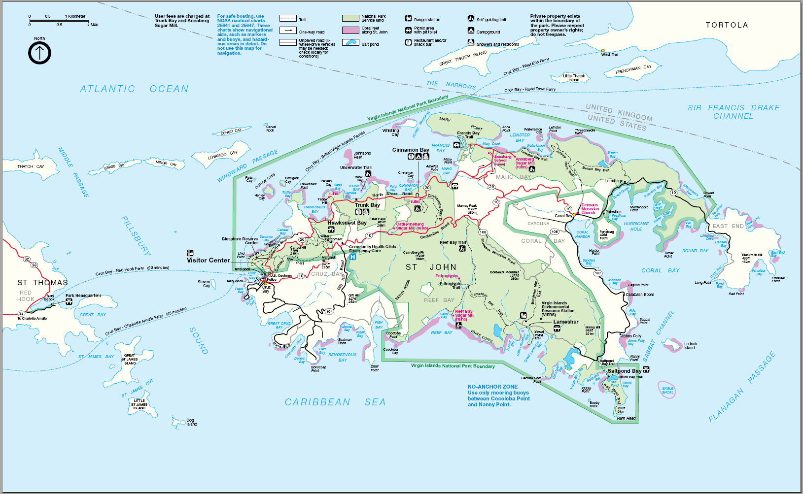
| Beskrivning | Map of Virgin Islands National Park — primarily on Saint John island, of the United States Virgin Islands. |
| Datum | Okänt datum |
| Källa | http://www.nps.gov |
| Skapare | Okänd |
| Tillstånd (Återanvändning av denna fil) |
PD |
| This image or media file contains material based on a work of a National Park Service employee, created as part of that person's official duties. As a work of the U.S. federal government, such work is in the public domain in the United States. See the NPS website and NPS copyright policy for more information. |
Filhistorik
Klicka på ett datum/klockslag för att se filen som den såg ut då.
| Datum/Tid | Miniatyrbild | Dimensioner | Användare | Kommentar | |
|---|---|---|---|---|---|
| nuvarande | 21 maj 2006 kl. 22.58 | | 1 629 × 1 003 (515 kbyte) | Huebi~commonswiki | {{Information| |Description=Map of Virgin Islands National Park |Source=http://www.nps.gov |Date=?? |Author=?? |Permission=PD |other_versions=?? }} ((PD-USGov-NPS}} |
Filanvändning
Följande sida använder den här filen:
Global filanvändning
Följande andra wikier använder denna fil:
- Användande på ar.wikipedia.org
- Användande på bg.wikipedia.org
- Användande på ca.wikipedia.org
- Användande på de.wikipedia.org
- Användande på en.wikipedia.org
- Användande på fr.wikipedia.org
- Användande på nl.wikipedia.org
- Användande på no.wikipedia.org
- Användande på pl.wikipedia.org
- Användande på ru.wikipedia.org
- Användande på tr.wikipedia.org
- Användande på uk.wikipedia.org
- Användande på vi.wikipedia.org
- Användande på www.wikidata.org