Fil:Vesta-Elevation.jpg
Det finns ingen version med högre upplösning.
Vesta-Elevation.jpg (500 × 500 pixlar, filstorlek: 43 kbyte, MIME-typ: image/jpeg)
| Denna fil tillhandahålls av Wikimedia Commons. Informationen nedan är kopierad från dess filbeskrivningssida. |
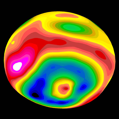
| Beskrivning |
A color-encoded elevation map of Vesta clearly shows the giant 460-kilometer diameter impact basin and "bull's-eye" central peak. The map was constructed from 78 Wide Field Planetary Camera 2 pictures. Surface topography was estimated by noting irregularities along the limb and at the terminator (day/night boundary) where shadows are enhanced by the low Sun angle. Deutsch: Farbkodierte Höhenkarte von Vesta.
Polski: Mapa Westy ukazująca różnice w wysokościach na jej powierzchni |
| Datum | Image published 1997 September 4 |
| Källa | http://hubblesite.org/newscenter/newsdesk/archive/releases/1997/27/image/e |
| Skapare | Ben Zellner (Georgia Southern University) and NASA |
| Tillstånd (Återanvändning av denna fil) |
Unless otherwise specifically stated, no claim to copyright is being asserted by STScI and it may be freely used as in the public domain in accordance with NASA's contract. [...] [1] |
| Denna fil är allmän egendom eftersom den skapades av NASA. NASA:s upphovsrättspolicy hävdar att "material från NASA inte är upphovsrättsskyddad om inte annat anges". (Se Template:PD-USGov, NASA:s upphovsrättspolicy eller JPL-bildanvändningspolicy.) | ||
 |
Varningar:
|
Filhistorik
Klicka på ett datum/klockslag för att se filen som den såg ut då.
| Datum/Tid | Miniatyrbild | Dimensioner | Användare | Kommentar | |
|---|---|---|---|---|---|
| nuvarande | 30 januari 2006 kl. 09.57 | | 500 × 500 (43 kbyte) | Arnomane | higher resolution |
| 24 augusti 2005 kl. 19.56 |  | 200 × 200 (6 kbyte) | Vesta~commonswiki | * Description: A color-encoded elevation map of Vesta clearly shows the giant 460-kilometer diameter impact basin and "bull's-eye" central peak. The map was constructed from 78 Wide Field Planetary Camera 2 pictures. Surface topography was estimated by no |
Filanvändning
Följande 2 sidor använder den här filen:
Global filanvändning
Följande andra wikier använder denna fil:
- Användande på als.wikipedia.org
- Användande på ar.wikipedia.org
- Användande på ca.wikipedia.org
- Användande på cs.wikipedia.org
- Användande på de.wikipedia.org
- Användande på en.wikipedia.org
- Användande på es.wikipedia.org
- Användande på eu.wikipedia.org
- Användande på fa.wikipedia.org
- Användande på fi.wikipedia.org
- Användande på fr.wikipedia.org
- Användande på ko.wikipedia.org
- Användande på lb.wikipedia.org
- Användande på mk.wikipedia.org
- Användande på oc.wikipedia.org
- Användande på pt.wikipedia.org
- Användande på ro.wikipedia.org
- Användande på simple.wikipedia.org
- Användande på sk.wikipedia.org
- Användande på uk.wikipedia.org
- Användande på www.wikidata.org
- Användande på zh.wikipedia.org