Fil:USATopographicalMap.jpg
Storlek på förhandsvisningen: 800 × 527 pixlar. Andra upplösningar: 320 × 211 pixlar | 640 × 422 pixlar | 1 024 × 674 pixlar | 1 280 × 843 pixlar | 2 560 × 1 686 pixlar | 3 199 × 2 107 pixlar.
Originalfil (3 199 × 2 107 pixlar, filstorlek: 11,19 Mbyte, MIME-typ: image/jpeg)
| Denna fil tillhandahålls av Wikimedia Commons. Informationen nedan är kopierad från dess filbeskrivningssida. |
Sammanfattning
| Beskrivning |
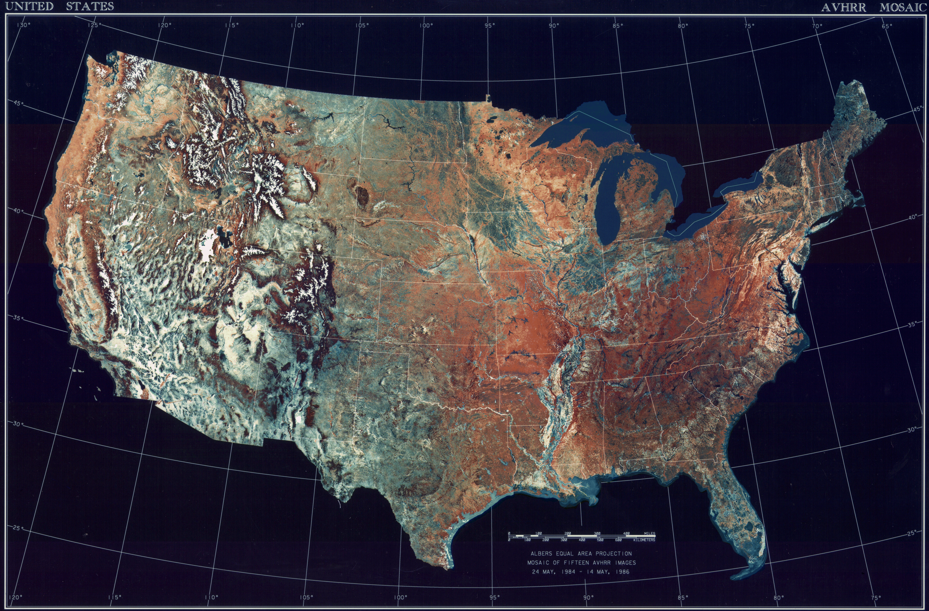
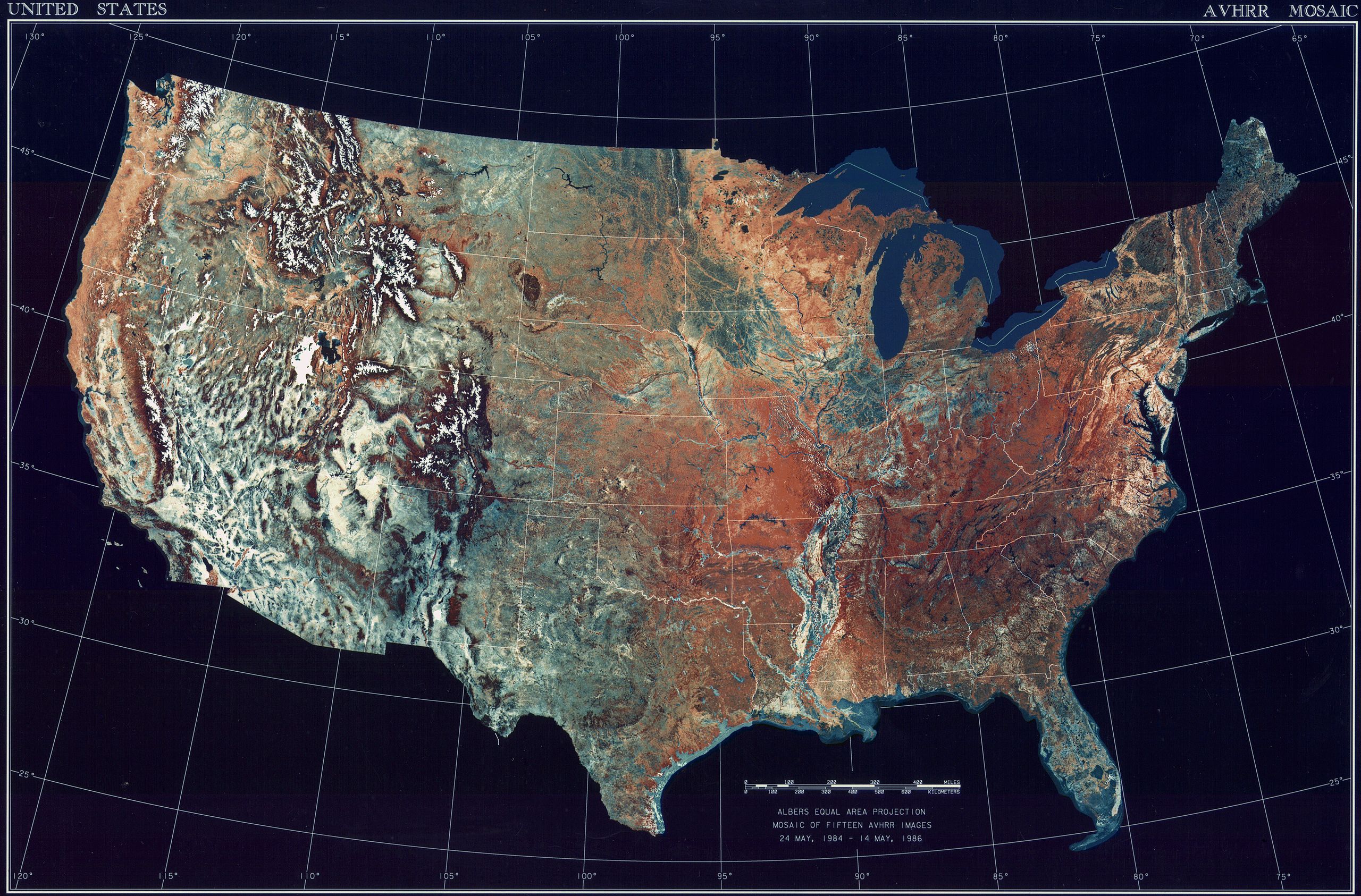
Deutsch: Satellitenbild der 48 Zentralstaaten der Vereinigten Staaten.
|
| Datum | mellan 24 maj 1984 och 14 maj 1986 |
| Källa | National Climactic Data Center/NOAA Satellite and Information Service |
| Skapare | U.S. Dept. of Commerce/National Climactic Data Center/NOAA Satellite and Information Service |
Licensiering
This image is in the public domain because it contains materials that originally came from the U.S. National Oceanic and Atmospheric Administration, taken or made as part of an employee's official duties.
|
Filhistorik
Klicka på ett datum/klockslag för att se filen som den såg ut då.
| Datum/Tid | Miniatyrbild | Dimensioner | Användare | Kommentar | |
|---|---|---|---|---|---|
| nuvarande | 25 oktober 2013 kl. 10.06 | | 3 199 × 2 107 (11,19 Mbyte) | McZusatz | compression (uploaded using chunked upload script) |
| 4 mars 2009 kl. 19.33 |  | 3 199 × 2 107 (450 kbyte) | File Upload Bot (Magnus Manske) | {{BotMoveToCommons|en.wikipedia|year={{subst:CURRENTYEAR}}|month={{subst:CURRENTMONTHNAME}}|day={{subst:CURRENTDAY}}}} {{Information |Description={{en|Topographical map of the United States}} |Source=Transferred from [http://en.wikipedia.org en.wikipedia |
Filanvändning
Följande sida använder den här filen:
Global filanvändning
Följande andra wikier använder denna fil:
- Användande på ar.wikipedia.org
- Användande på arz.wikipedia.org
- Användande på ceb.wikipedia.org
- Användande på de.wikipedia.org
- Användande på el.wikipedia.org
- Användande på en.wikipedia.org
- Användande på es.wikipedia.org
- Användande på fa.wikipedia.org
- Användande på fr.wikipedia.org
- Användande på fy.wikipedia.org
- Användande på gu.wikipedia.org
- Användande på he.wikipedia.org
- Användande på ia.wikipedia.org
- Användande på incubator.wikimedia.org
- Användande på kn.wikipedia.org
- Användande på la.wikipedia.org
- Användande på lt.wikipedia.org
- Användande på mnw.wikipedia.org
- Användande på ms.wikipedia.org
- Användande på my.wikipedia.org
- Användande på pap.wikipedia.org
- Användande på sq.wikipedia.org
- Användande på sw.wikipedia.org
- Användande på ta.wikipedia.org
- Användande på tcy.wikipedia.org
- Användande på th.wikipedia.org
- Användande på tl.wikipedia.org
- Användande på uk.wikipedia.org
- Användande på www.wikidata.org
- Användande på yo.wikipedia.org