Fil:Trafalgar 1200hr.svg

Storleken för denna PNG-förhandsvisning av denna SVG-fil: 606 × 599 pixlar. Andra upplösningar: 243 × 240 pixlar | 485 × 480 pixlar | 776 × 768 pixlar | 1 035 × 1 024 pixlar | 2 070 × 2 048 pixlar | 743 × 735 pixlar.
Originalfil (SVG-fil, standardstorlek: 743 × 735 pixlar, filstorlek: 77 kbyte)
| Denna fil tillhandahålls av Wikimedia Commons. Informationen nedan är kopierad från dess filbeskrivningssida. |
Sammanfattning
| Beskrivning |
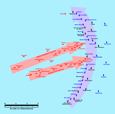
English: This map of the Battle of Trafalgar shows the approximate position of the two fleets at 1200 hours during the battle as the Royal Sovereign was breaking into the Franco-Spanish line. North is to the top, and Cape Trafalgar is 10 miles to the northeast. |
| Datum | |
| Källa | own work made with Inkscape from Image:Trafalgar 1200hr.gif : This drawing is based on an illustration in issue number 84 of the Strategy & Tactics magazine The map was made by RJHall using the Campaign Cartographer drawing program, and the image was reduced in size 50% in Paint Shop Pro. Ship icons are not to scale. |
| Skapare | Pinpin |
Den här W3C-overifiera vektorbilden skapades med Inkscape .
Licensiering
Jag, upphovsrättsinnehavaren av detta verk, publicerar härmed det under följande licenser:

|
Tillstånd ges att kopiera, distribuera och/eller modifiera detta dokument under villkoren i GNU Free Documentation License, Version 1.2 eller senare version publicerad av Free Software Foundation, utan oföränderliga avsnitt, framsidestexter eller baksidestexter. En kopia av licensen ingår i avsnittet GNU Free Documentation License. |
Denna fil har gjorts tillgänglig under licenserna Creative Commons Erkännande-DelaLika 3.0 Unported, 2.5 Generisk, 2.0 Generisk och 1.0 Generisk.
- Du är fri:
- att dela – att kopiera, distribuera och sända verket
- att remixa – att skapa bearbetningar
- På följande villkor:
- erkännande – Du måste ge lämpligt erkännande, ange en länk till licensen och indikera om ändringar har gjorts. Du får göra det på ett lämpligt sätt, men inte på ett sätt som antyder att licensgivaren stödjer dig eller din användning.
- dela lika – Om du remixar, transformerar eller bygger vidare på materialet måste du distribuera dina bidrag under samma eller en kompatibel licens som originalet.
Du får själv välja den licens du vill använda.
Filhistorik
Klicka på ett datum/klockslag för att se filen som den såg ut då.
| Datum/Tid | Miniatyrbild | Dimensioner | Användare | Kommentar | |
|---|---|---|---|---|---|
| nuvarande | 29 januari 2008 kl. 05.45 | | 743 × 735 (77 kbyte) | Uhanu | I forgot the colour of Belleisle. |
| 29 januari 2008 kl. 05.43 |  | 743 × 735 (77 kbyte) | Uhanu | Correcting some names: Montañés , San Ildefonso, Agamemnon, Duguay-Trouin... and colour of Belleisle. | |
| 14 december 2007 kl. 20.55 |  | 743 × 735 (77 kbyte) | Rama | Original SVG version at Image:Trafalgar 1200hr.gif * '''Description:''' This map of the '''Battle of Trafalgar''' shows the approximate position of the two fleets at 1200 hours during the battle as the Royal Sovereign was breaking into the Franc | |
| 3 oktober 2007 kl. 22.11 |  | 900 × 850 (73 kbyte) | Pinpin | I forget one boat | |
| 3 oktober 2007 kl. 22.04 |  | 900 × 850 (72 kbyte) | Pinpin | {{Information |Description={{en|This map of the '''Battle of Trafalgar''' shows the approximate position of the two fleets at 1200 hours during the battle as the Royal Sovereign was breaking into the Franco-Spanish line. North is to the top, and Cape |
Filanvändning
Följande sida använder den här filen:
Global filanvändning
Följande andra wikier använder denna fil:
- Användande på azb.wikipedia.org
- Användande på bg.wikipedia.org
- Användande på ca.wikipedia.org
- Användande på de.wikipedia.org
- Användande på el.wikipedia.org
- Användande på en.wikipedia.org
- Användande på es.wikipedia.org
- Användande på et.wikipedia.org
- Användande på fi.wikipedia.org
- Användande på he.wikipedia.org
- Användande på hu.wikipedia.org
- Användande på io.wikipedia.org
- Användande på it.wikipedia.org
- Användande på ja.wikipedia.org
- Användande på nl.wikipedia.org
- Användande på no.wikipedia.org
- Användande på ro.wikipedia.org
- Användande på ru.wikipedia.org
- Användande på sr.wikipedia.org
- Användande på th.wikipedia.org
- Användande på vi.wikipedia.org
- Användande på www.wikidata.org