Fil:Tobaeruption.png

Storlek på förhandsvisningen: 800 × 593 pixlar. Andra upplösningar: 320 × 237 pixlar | 640 × 474 pixlar | 1 024 × 759 pixlar | 1 280 × 948 pixlar | 1 620 × 1 200 pixlar.
Originalfil (1 620 × 1 200 pixlar, filstorlek: 1,43 Mbyte, MIME-typ: image/png)
| Denna fil tillhandahålls av Wikimedia Commons. Informationen nedan är kopierad från dess filbeskrivningssida. |
Sammanfattning
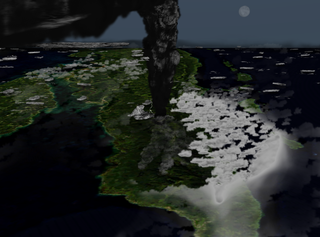
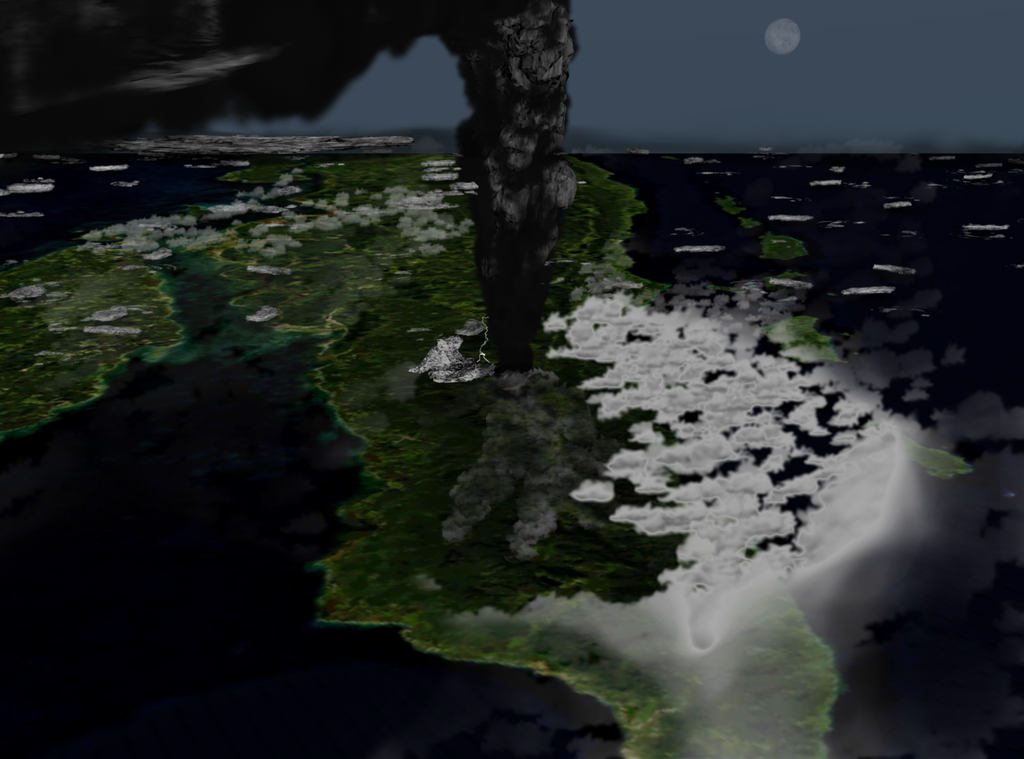
| Beskrivning | Illustration of what the Toba eruption might have looked like around 42 km above northern Sumatra. |
| Datum | (UTC) |
| Källa |
Eget arbete
|
| Skapare | Anynobody |
Licensiering
Jag, upphovsrättsinnehavaren av detta verk, publicerar härmed det under följande licenser:

|
Tillstånd ges att kopiera, distribuera och/eller modifiera detta dokument under villkoren i GNU Free Documentation License, Version 1.2 eller senare version publicerad av Free Software Foundation, utan oföränderliga avsnitt, framsidestexter eller baksidestexter. En kopia av licensen ingår i avsnittet GNU Free Documentation License. |
This file is licensed under the Creative Commons Attribution-Share Alike 4.0 International, 3.0 Unported, 2.5 Generic, 2.0 Generic and 1.0 Generic license.
- Du är fri:
- att dela – att kopiera, distribuera och sända verket
- att remixa – att skapa bearbetningar
- På följande villkor:
- erkännande – Du måste ge lämpligt erkännande, ange en länk till licensen och indikera om ändringar har gjorts. Du får göra det på ett lämpligt sätt, men inte på ett sätt som antyder att licensgivaren stödjer dig eller din användning.
- dela lika – Om du remixar, transformerar eller bygger vidare på materialet måste du distribuera dina bidrag under samma eller en kompatibel licens som originalet.
Du får själv välja den licens du vill använda.
Filhistorik
Klicka på ett datum/klockslag för att se filen som den såg ut då.
| Datum/Tid | Miniatyrbild | Dimensioner | Användare | Kommentar | |
|---|---|---|---|---|---|
| nuvarande | 19 augusti 2009 kl. 02.39 | | 1 620 × 1 200 (1,43 Mbyte) | Anynobody~commonswiki | oops, last upload was a study, this is what I meant to upload |
| 17 augusti 2009 kl. 05.00 |  | 1 845 × 1 494 (941 kbyte) | Anynobody~commonswiki | lighter, better plume and weather | |
| 6 november 2008 kl. 04.30 |  | 1 750 × 1 312 (1,7 Mbyte) | Anynobody~commonswiki | new version/perspective | |
| 8 augusti 2008 kl. 05.16 |  | 1 550 × 1 372 (2,2 Mbyte) | Anynobody~commonswiki | highlighting compass rose | |
| 12 april 2008 kl. 08.26 |  | 1 550 × 1 372 (2,2 Mbyte) | Anynobody~commonswiki | added subtle compass rose | |
| 10 februari 2008 kl. 10.00 |  | 1 550 × 1 372 (2,19 Mbyte) | Anynobody~commonswiki | {{Information |Description=Illustration of what the last major Toba eruption looked like. |Source=self-made |Date= ~~~~~ |Author= Anynobody |Permission= |other_versions= }} |
Filanvändning
Följande sida använder den här filen:
Global filanvändning
Följande andra wikier använder denna fil:
- Användande på ar.wikipedia.org
- Användande på be.wikipedia.org
- Användande på bg.wikipedia.org
- Användande på bn.wikipedia.org
- Användande på cs.wikipedia.org
- Användande på en.wikipedia.org
- Användande på es.wikipedia.org
- Användande på eu.wikipedia.org
- Användande på fa.wikipedia.org
- Användande på fr.wikipedia.org
- Användande på id.wikipedia.org
- Användande på it.wikipedia.org
- Användande på ja.wikipedia.org
- Användande på ko.wikipedia.org
- Användande på min.wikipedia.org
- Användande på ms.wikipedia.org
- Användande på pt.wikipedia.org
- Användande på ro.wikipedia.org
- Användande på ta.wikipedia.org
- Användande på te.wikipedia.org
- Användande på tl.wikipedia.org
- Användande på tr.wikipedia.org
- Användande på tt.wikipedia.org
- Användande på uk.wikipedia.org
- Användande på zh.wikipedia.org