Originalfil(2 000 × 1 534 pixlar, filstorlek: 346 kbyte, MIME-typ: image/png)

En vektorversion av denna bild (SVG) finns tillgänglig.
Den skall användas istället för denna rasterbild, när det är fördelaktigt.

File:Rzeczpospolita 1923.png → File:Rzeczpospolita 1938.svg

För mer information om vektorgrafik, se artikeln Commons transition to SVG (engelska).
Det finns också information om MediaWikis stöd för SVG-bilder (engelska).

På andra språk
Alemannisch  Bahasa Indonesia  Bahasa Melayu  British English  català  čeština  dansk  Deutsch  eesti  English  español  Esperanto  euskara  français  Frysk  galego  hrvatski  Ido  italiano  lietuvių  magyar  Nederlands  norsk bokmål  norsk nynorsk  occitan  Plattdüütsch  polski  português  português do Brasil  română  Scots  sicilianu  slovenčina  slovenščina  suomi  svenska  Tiếng Việt  Türkçe  vèneto  Ελληνικά  беларуская (тарашкевіца)  български  македонски  нохчийн  русский  српски / srpski  татарча/tatarça  українська  ქართული  հայերեն  বাংলা  தமிழ்  മലയാളം  ไทย  한국어  日本語  简体中文  繁體中文  עברית  العربية  فارسی  +/−
Ny SVG-bild

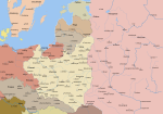
Early version of my map of Poland and Eastern Europe between 1918 and 1945. So far it features the borders and major towns and cities, as well as the frontlines of the Polish-Bolshevik War.
The colours and fonts and other stuff will be added soon.

Based on my maps of the Polish-Lithuanian Commonwealth series, colours stolen from some German map printed in 1938
The following is a list of maps created by Halibutt and uploaded to commons, as well as their present and projected derivatives.

Parent Image Image Description
  Maps by Halibutt
Image:Rzeczpospolita.png Image:Rzeczpospolita.png The Republic in 17th and 18th century
Image:Rzeczpospolita 1600.png The Republic after the Treaty of Dywilino
Image:Rzeczpospolita voivodships.png Voivodships of The Republic
Image:Rzeczpospolita_Potop.png The Republic during The Deluge and Chmielnicki Uprising, with major battles of the era marked
Magnates and their lands and domains
1st2nd3rd Partitions of Poland
War of the constitution
Image:Rzeczpospolita.xcf SOURCE FILE - GIMP format
Image:Poland 1939.png Image:Poland 1939.png Poland in 1939
Image:Dywizje wrzesien 1.png Order of Battle on September 1st, during the Polish Defence War of 1939
Image:Poland 1939.xcf SOURCE FILE - GIMP format
Image:Polska kontur bialy.png Image:Polska kontur bialy.png Contour map of Poland AD 1999, for use with various locator maps
Image:Rzeczpospolita 1923.png Image:Rzeczpospolita 1923.png Map of Poland 1918-1939, currently under development
Image:PBW March 1919.png Polish-Bolshevik War - fronts in March of 1919
Image:PBW December 1919.png Polish-Bolshevik War - fronts in December of 1919
Image:PBW June 1920.png Polish-Bolshevik War - fronts in July of 1920
Image:PBW August 1920.png Polish-Bolshevik War - fronts in August of 1920
Polish Defence War of 1939
Polish areas annexed by Germany, Lithuania, Slovakia and the Soviet Union
German concentration camps in Poland
Curzon line
Major battles of the Polish-Bolshevik War
namesno names Polish/Czechoslovak/Lithuanian/German/Ukrainian claims in 1920's
Image:Rzeczpospolita Central Lithuania.png Central Lithuania
Image:Rzeczpospolita Lithuania claims.png Central Lithuania as compared with other Lithuanian claims
Image:Rzeczpospolita 1789-1920.png Post-1922 borders compared with the territory of Poland before the partitions
Warsaw Uprising and the Operation Tempest
Poland partitioned between the Soviets and the Germans
Image:Rzeczpospolita 1939 Polish divisions.png Polish divisions on September 1, 1939
Home Army inspectorates
Image:Rzeczpospolita 1922.xcf SOURCE FILE - GIMP format
Image:Rzeczpospolita 1937.svg Vector version!!!! layered version available on request


There is an alternate version at Image:Rzeczpospolita 1920 captioned.png with country names added.


Copyright notice: Image made by Halibutt and uploaded to Wikipedia by the author. Images can be made available for use under other copyleft licenses on a case by case basis via direct contact with the author. Under moral rights the user requires that this work be properly attributed to its creator. For photographs, this is traditionally done in the image caption. Where a copyright notice is present, using the copyright notice in the caption will be sufficient. Note that the GFDL requires that any copyright notices be included with the work even when making unmodified use of it.

Since the legal status of the above comment has been questioned, I hereby grant anyone the right to treat it as either a standard copyright notice, invariant section, legal statement, legal advice, friendly suggestion or a mere comment, depending on his or hers own choice.
Halibutt
GNU head Tillstånd ges att kopiera, distribuera och/eller modifiera detta dokument under villkoren i GNU Free Documentation License, Version 1.2 eller senare version publicerad av Free Software Foundation, utan oföränderliga avsnitt, framsidestexter eller baksidestexter. En kopia av licensen ingår i avsnittet GNU Free Documentation License.
w:sv:Creative Commons
erkännande dela lika
Denna fil har gjorts tillgänglig under licensen Creative Commons Erkännande-Dela Lika 3.0 Generisk
Du är fri:
  • att dela – att kopiera, distribuera och sända verket
  • att remixa – att skapa bearbetningar
På följande villkor:
  • erkännande – Du måste ge lämpligt erkännande, ange en länk till licensen och indikera om ändringar har gjorts. Du får göra det på ett lämpligt sätt, men inte på ett sätt som antyder att licensgivaren stödjer dig eller din användning.
  • dela lika – Om du remixar, transformerar eller bygger vidare på materialet måste du distribuera dina bidrag under samma eller en kompatibel licens som originalet.
Detta licenstillägg lades till till denna fil som en del av GFDL:s licensuppdatering.

Bildtexter

Ingen bildtext har definierats

Objekt som porträtteras i den här filen

motiv

Filhistorik

Klicka på ett datum/klockslag för att se filen som den såg ut då.

(nyaste | äldsta) Visa (10 nyare | ) (10 | 20 | 50 | 100 | 250 | 500)
Datum/TidMiniatyrbildDimensionerAnvändareKommentar
nuvarande25 mars 2017 kl. 23.24Miniatyrbild för versionen från den 25 mars 2017 kl. 23.242 000 × 1 534 (346 kbyte)Bogomolov.PLcorrected Tsaritsyn >>> Voronezh
3 augusti 2012 kl. 20.10Miniatyrbild för versionen från den 3 augusti 2012 kl. 20.102 000 × 1 534 (309 kbyte)KaganerVolgograd -> Tsaritsyn (renamed only in 1925)
24 februari 2010 kl. 17.07Miniatyrbild för versionen från den 24 februari 2010 kl. 17.072 000 × 1 534 (234 kbyte)DcoetzeeRemove watermark, pngcrush
5 december 2009 kl. 10.35Miniatyrbild för versionen från den 5 december 2009 kl. 10.352 000 × 1 534 (361 kbyte)DJ SturmCorrect borders, improved Estonia
16 augusti 2009 kl. 16.37Miniatyrbild för versionen från den 16 augusti 2009 kl. 16.372 000 × 1 534 (342 kbyte)HalibuttReverted to version as of 06:33, 8 May 2005 (don't do this. Modify the svg version instead, without those horrible colours and copy-paste leftovers)
27 mars 2009 kl. 16.30Miniatyrbild för versionen från den 27 mars 2009 kl. 16.302 000 × 1 534 (360 kbyte)DJ SturmFixed borders of Estonia, Latvia, Lithuania, Soviet Union and Germany, added some towns.
8 maj 2005 kl. 08.33Miniatyrbild för versionen från den 8 maj 2005 kl. 08.332 000 × 1 534 (342 kbyte)HalibuttReverted to earlier revision
7 maj 2005 kl. 23.41Miniatyrbild för versionen från den 7 maj 2005 kl. 23.412 000 × 1 534 (308 kbyte)DeirYassin~commonswikiCorrected borders of Latvia and Russia, Estonia and Russia according to real interwar, rather than current, borders; the Lithuanian claim is shown.
7 maj 2005 kl. 22.50Miniatyrbild för versionen från den 7 maj 2005 kl. 22.502 000 × 1 534 (308 kbyte)DeirYassin~commonswiki
7 maj 2005 kl. 22.47Miniatyrbild för versionen från den 7 maj 2005 kl. 22.472 000 × 1 534 (308 kbyte)DeirYassin~commonswiki
(nyaste | äldsta) Visa (10 nyare | ) (10 | 20 | 50 | 100 | 250 | 500)

Följande sida använder den här filen:

Global filanvändning

Följande andra wikier använder denna fil:

Visa mer globalt användande av denna fil.

Metadata