Fil:Reigate and Banstead UK locator map.svg

Storleken för denna PNG-förhandsvisning av denna SVG-fil: 790 × 599 pixlar. Andra upplösningar: 317 × 240 pixlar | 633 × 480 pixlar | 1 013 × 768 pixlar | 1 280 × 971 pixlar | 2 560 × 1 942 pixlar | 1 425 × 1 081 pixlar.
Originalfil (SVG-fil, standardstorlek: 1 425 × 1 081 pixlar, filstorlek: 948 kbyte)
| Denna fil tillhandahålls av Wikimedia Commons. Informationen nedan är kopierad från dess filbeskrivningssida. |
| Beskrivning |
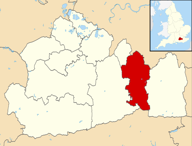
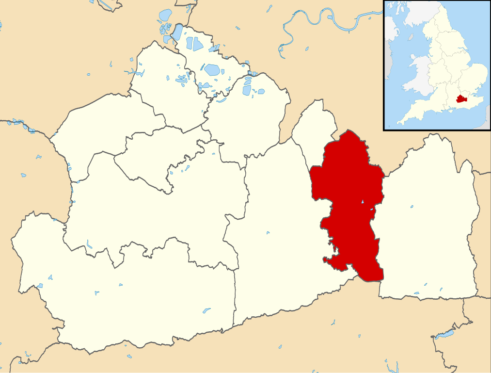
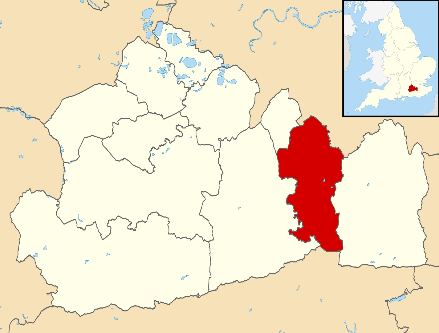
Map of Surrey, UK with Reigate and Banstead highlighted. Equirectangular map projection on WGS 84 datum, with N/S stretched 160% |
| Datum | |
| Källa |
|
| Skapare | Nilfanion, created using Ordnance Survey data |
| Tillstånd (Återanvändning av denna fil) |
Denna fil har gjorts tillgänglig under licensen Creative Commons Erkännande-Dela Lika 3.0 Generisk Erkännande: Contains Ordnance Survey data © Crown copyright and database right
|
Filhistorik
Klicka på ett datum/klockslag för att se filen som den såg ut då.
| Datum/Tid | Miniatyrbild | Dimensioner | Användare | Kommentar | |
|---|---|---|---|---|---|
| nuvarande | 2 augusti 2011 kl. 11.27 | | 1 425 × 1 081 (948 kbyte) | Nilfanion | {{Information |Description=Map of Surrey, UK with w:Reigate and Banstead highlighted. Equirectangular map projection on WGS 84 datum, with N/S stretched 160% |Source=Ordnance Survey [https://www.ordnancesurvey.co.u |
Filanvändning
Följande sida använder den här filen:
Global filanvändning
Följande andra wikier använder denna fil:
- Användande på cy.wikipedia.org
- Användande på en.wikipedia.org
- Reigate and Banstead
- Reigate
- Redhill, Surrey
- Tadworth
- Royal Earlswood Hospital
- Reigate Grammar School
- Horley
- Merstham
- Banstead railway station
- Woodmansterne railway station
- Redhill railway station
- Merstham railway station
- Horley railway station
- Earlswood railway station (Surrey)
- Tattenham Corner railway station
- Walton-on-the-Hill
- Hooley
- Salfords
- Banstead
- Earlswood
- Meadvale
- Tattenham Corner
- Nork, Surrey
- Burgh Heath
- Kingswood, Surrey
- Banstead Athletic F.C.
- Chipstead F.C.
- Merstham F.C.
- Horley Town F.C.
- Redhill F.C.
- Kingswood railway station
- Lower Kingswood
- Chipstead, Surrey
- South Park F.C.
- Aberdour School
- Reigate railway station
- Redhill Aerodrome
- St Bede's School
- Chipstead railway station
- Reigate Priory F.C.
- Woodmansterne
- Royal Alexandra and Albert School
- Reigate Priory
- Priory Preparatory School
- Chipstead Downs
- Reigate College
- Reigate School
- East Surrey College
- Netherne-on-the-Hill
Visa mer globalt användande av denna fil.