Fil:LocationSouthPeru.png
Det finns ingen version med högre upplösning.
LocationSouthPeru.png (250 × 122 pixlar, filstorlek: 7 kbyte, MIME-typ: image/png)
| Denna fil tillhandahålls av Wikimedia Commons. Informationen nedan är kopierad från dess filbeskrivningssida. |
Sammanfattning
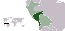
| Beskrivning | Location map of the South Peru within the Peru-Bolivian Confederation | ||||||||
| Datum | |||||||||
| Källa | Based on Image:Location ConfederaciónPerú-Boliviana.png | ||||||||
| Skapare | Domino theory | ||||||||
| Tillstånd (Återanvändning av denna fil) |
Jag, upphovsrättsinnehavaren av detta verk, publicerar härmed det under följande licenser:
Du får själv välja den licens du vill använda. |
||||||||
| Andra versioner | Image:LocationNorthPeru.png |

Filhistorik
Klicka på ett datum/klockslag för att se filen som den såg ut då.
| Datum/Tid | Miniatyrbild | Dimensioner | Användare | Kommentar | |
|---|---|---|---|---|---|
| nuvarande | 30 oktober 2006 kl. 06.49 | | 250 × 122 (7 kbyte) | Huhsunqu | |
| 12 oktober 2006 kl. 16.45 |  | 250 × 122 (7 kbyte) | Domino theory | == Summary == {{Information |Description=Location map of the South Peru within the Peru-Bolivian Confederation |Source=Based on [[:Image:Location ConfederaciónPerú-Boliviana.png] |
Filanvändning
Inga sidor använder den här filen.