Fil:Kingdoms around Israel 830 map.svg

Storleken för denna PNG-förhandsvisning av denna SVG-fil: 502 × 599 pixlar. Andra upplösningar: 201 × 240 pixlar | 402 × 480 pixlar | 644 × 768 pixlar | 858 × 1 024 pixlar | 1 717 × 2 048 pixlar | 720 × 859 pixlar.
Originalfil (SVG-fil, standardstorlek: 720 × 859 pixlar, filstorlek: 122 kbyte)
| Denna fil tillhandahålls av Wikimedia Commons. Informationen nedan är kopierad från dess filbeskrivningssida. |
| Beskrivning |
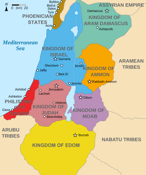
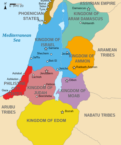
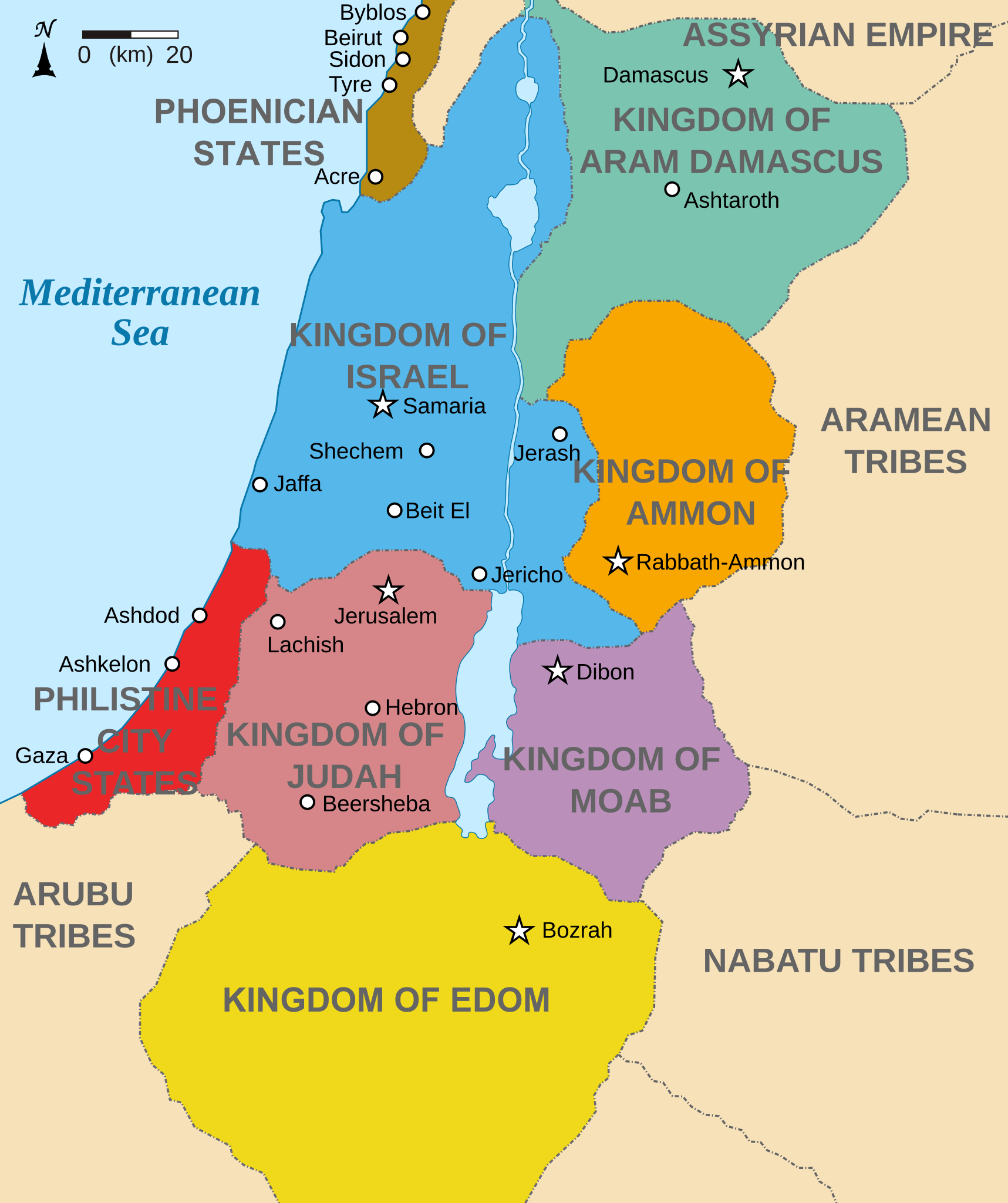
English: Map showing states around Israel & Judah. The Kingdoms around Israel & Judah are colored:
|
| Datum | (UTC) |
| Källa | |
| Skapare |
|
| Andra versioner |
[]
|


Jag, upphovsrättsinnehavaren av detta verk, publicerar härmed det under följande licenser:
Denna fil har gjorts tillgänglig under licensen Creative Commons Erkännande-Dela Lika 3.0 Generisk
- Du är fri:
- att dela – att kopiera, distribuera och sända verket
- att remixa – att skapa bearbetningar
- På följande villkor:
- erkännande – Du måste ge lämpligt erkännande, ange en länk till licensen och indikera om ändringar har gjorts. Du får göra det på ett lämpligt sätt, men inte på ett sätt som antyder att licensgivaren stödjer dig eller din användning.
- dela lika – Om du remixar, transformerar eller bygger vidare på materialet måste du distribuera dina bidrag under samma eller en kompatibel licens som originalet.

|
Tillstånd ges att kopiera, distribuera och/eller modifiera detta dokument under villkoren i GNU Free Documentation License, Version 1.2 eller senare version publicerad av Free Software Foundation, utan oföränderliga avsnitt, framsidestexter eller baksidestexter. En kopia av licensen ingår i avsnittet GNU Free Documentation License. |
Du får själv välja den licens du vill använda.
Ursprunglig uppladdningslogg
This image is a derivative work of the following images:
- File:Kingdoms_of_Israel_and_Judah_map_830.svg licensed with Cc-by-sa-3.0, GFDL
- 2010-07-13T10:51:49Z Richardprins 720x859 (80858 Bytes) Added colors for the two kingdoms and converted their text to path and arial
- 2010-07-12T23:53:35Z Richardprins 720x859 (63843 Bytes) Shrinked down the borders
- 2010-07-12T19:43:31Z Richardprins 720x859 (63800 Bytes) {{Information |Description={{en|1=Map showing the ancient levant borders and ancient cities such as [[Urmomium]] and [[Jerash]]. The map also shows the region in the 9th century BCE. Notice the coastal land of Philistia, from
Uploaded with derivativeFX
Filhistorik
Klicka på ett datum/klockslag för att se filen som den såg ut då.
| Datum/Tid | Miniatyrbild | Dimensioner | Användare | Kommentar | |
|---|---|---|---|---|---|
| nuvarande | 29 oktober 2022 kl. 17.32 | | 720 × 859 (122 kbyte) | Muchado | Fixing font problems (hopefully) |
| 29 oktober 2022 kl. 17.11 |  | 720 × 859 (283 kbyte) | Muchado | Added "Philistine City States" which was unintentionally missed off... | |
| 29 oktober 2022 kl. 17.06 |  | 720 × 859 (239 kbyte) | Muchado | Coloured states, removed anachronistic Petra, added Bozrah, removed Urmomium (Your mom...!), edited Arabu to Arubu, edited to Philistine City States | |
| 10 februari 2017 kl. 17.51 |  | 720 × 859 (167 kbyte) | Malus Catulus | Removed 'Sizu' - a weird artifact from the Norse original | |
| 13 juli 2010 kl. 14.58 |  | 720 × 859 (165 kbyte) | Malus Catulus | livened up the colors, converted med sea text to path | |
| 13 juli 2010 kl. 13.26 |  | 720 × 859 (139 kbyte) | Malus Catulus | {{Information |Description={{en|1=Map showing the ancient levant borders and ancient cities such as Urmomium and Jerash. The Kingdoms around Israel and Judah are colored. The map also shows the region in the 9th century BCE. Notice the coastal lan |
Filanvändning
Global filanvändning
Följande andra wikier använder denna fil:
- Användande på af.wikipedia.org
- Användande på arc.wikipedia.org
- Användande på ar.wikipedia.org
- Användande på arz.wikipedia.org
- Användande på azb.wikipedia.org
- Användande på bg.wikipedia.org
- Användande på bn.wikipedia.org
- Användande på br.wikipedia.org
- Användande på ca.wikipedia.org
- Användande på cs.wikipedia.org
- Användande på da.wikipedia.org
- Användande på en.wikipedia.org
- Ammon
- History of the ancient Levant
- Kingdom of Judah
- Kingdom of Israel (Samaria)
- Philistines
- Moab
- Philistia
- Talk:Phoenician language
- Aram-Damascus
- Edom
- Portal:Bible/Featured chapter/Psalms
- Portal:Bible/Featured chapter/Psalms 83
- User:Kazkaskazkasako/Books/History
- Transjordan (region)
- Ezekiel 25
- User:Falcaorib
- User:Jacksonmcdonald3425/sandbox
- Användande på en.wiktionary.org
- Användande på eo.wikipedia.org
- Användande på et.wikipedia.org
- Användande på eu.wikipedia.org
Visa mer globalt användande av denna fil.