Fil:Khuriya muriya 76.jpg

Det finns ingen version med högre upplösning.
Khuriya_muriya_76.jpg (436 × 360 pixlar, filstorlek: 31 kbyte, MIME-typ: image/jpeg)
| Denna fil tillhandahålls av Wikimedia Commons. Informationen nedan är kopierad från dess filbeskrivningssida. |
Sammanfattning
| Beskrivning |
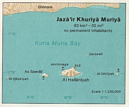
Deutsch: Karte der Kuria-Muria-Inseln (Oman) im Indischen Ozean
English: Map of Khuriya Muriya Islands (Oman) in the Indian Ocean |
| Datum | |
| Källa | http://www.lib.utexas.edu/maps/islands_oceans_poles/jaza'ir_khuriya_muriya.jpg |
| Skapare | Taken from Perry-Castañeda Library (PCL), originally from CIA Indian Ocean Atlas |
Licensiering
| This image is a work of a Central Intelligence Agency employee, taken or made as part of that person's official duties. As a Work of the United States Government, this image or media is in the public domain in the United States.
|

|
Filhistorik
Klicka på ett datum/klockslag för att se filen som den såg ut då.
| Datum/Tid | Miniatyrbild | Dimensioner | Användare | Kommentar | |
|---|---|---|---|---|---|
| nuvarande | 10 juli 2007 kl. 13.50 | | 436 × 360 (31 kbyte) | Telim tor | == Information == {{Information |Description= {{de|Karte der Kuria-Muria-Inseln (Oman) im Indischen Ozean}} {{en|Map of Khuriya Muriya Islands (Oman) in the Indian Ocean}} |Source=http://www.lib.utexas.edu/maps/islands_oceans_poles/jaza'ir_khuriya_muriya. |
Filanvändning
Följande sida använder den här filen:
Global filanvändning
Följande andra wikier använder denna fil:
- Användande på ar.wikipedia.org
- Användande på az.wikipedia.org
- Användande på be.wikipedia.org
- Användande på ca.wikipedia.org
- Användande på ceb.wikipedia.org
- Användande på cs.wikipedia.org
- Användande på de.wikipedia.org
- Användande på en.wikipedia.org
- Användande på eo.wikipedia.org
- Användande på es.wikipedia.org
- Användande på fa.wikipedia.org
- Användande på fi.wikipedia.org
- Användande på fr.wikipedia.org
- Användande på it.wikipedia.org
- Användande på ja.wikipedia.org
- Användande på lt.wikipedia.org
- Användande på nl.wikipedia.org
- Användande på nn.wikipedia.org
- Användande på no.wikipedia.org
- Användande på pl.wikipedia.org
- Användande på pt.wikipedia.org
- Användande på ru.wikipedia.org
- Användande på sr.wikipedia.org
- Användande på uk.wikipedia.org
- Användande på www.wikidata.org
- Användande på zh.wikipedia.org