Fil:Kansas City Kansas aerial view.jpg

Storlek på förhandsvisningen: 800 × 534 pixlar. Andra upplösningar: 320 × 214 pixlar | 640 × 427 pixlar | 1 024 × 683 pixlar | 1 500 × 1 001 pixlar.
Originalfil (1 500 × 1 001 pixlar, filstorlek: 579 kbyte, MIME-typ: image/jpeg)
| Denna fil tillhandahålls av Wikimedia Commons. Informationen nedan är kopierad från dess filbeskrivningssida. |
Sammanfattning
| Beskrivning |
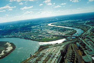
English: Aerial view of Kansas City, Kansas, looking southwest. The Kansas River (right-center) joins the Missouri River (left). A small piece of Kansas City, Missouri is visible on the left of the Missouri River. |
| Plats | City of Kansas City, State of Kansas, United States of America 39°6′54.64″N 94°36′36.34″W / 39.1151778°N 94.6100944°W |
| Datum | Bild tagen: 6 april 1999 |
| Källa |
U.S. Army Corp of Engineers Digital Visual Library Image page Image description page Digital Visual Library home page |
| Skapare | U.S. Army Corps of Engineers, photographer unknown |
Licensiering
This image or file is a work of a U.S. Army Corps of Engineers soldier or employee, taken or made as part of that person's official duties. As a work of the U.S. federal government, the image is in the public domain.
|
Filhistorik
Klicka på ett datum/klockslag för att se filen som den såg ut då.
| Datum/Tid | Miniatyrbild | Dimensioner | Användare | Kommentar | |
|---|---|---|---|---|---|
| nuvarande | 17 mars 2007 kl. 03.48 | | 1 500 × 1 001 (579 kbyte) | DanMS | {{Information | Description = Aerial view of Kansas City, Kansas, looking southwest. The Kansas River (right-center) joins the Missouri River (left). A small piece of Kansas City, Missouri is visible on the left of the Missouri River. | Source = U.S. |
Filanvändning
Följande sida använder den här filen:
Global filanvändning
Följande andra wikier använder denna fil:
- Användande på bo.wikipedia.org
- Användande på br.wikipedia.org
- Användande på cs.wikipedia.org
- Användande på da.wikipedia.org
- Användande på de.wikipedia.org
- Användande på en.wikipedia.org
- Användande på eo.wikipedia.org
- Användande på es.wikipedia.org
- Användande på fr.wikipedia.org
- Användande på gd.wikipedia.org
- Användande på gu.wikipedia.org
- Användande på gv.wikipedia.org
- Användande på hsb.wikipedia.org
- Användande på hu.wikipedia.org
- Användande på hy.wikipedia.org
- Användande på id.wikipedia.org
- Användande på ja.wikipedia.org
- Användande på kn.wikipedia.org
- Användande på ko.wikipedia.org
- Användande på kw.wikipedia.org
- Användande på ky.wikipedia.org
- Användande på la.wikipedia.org
- Användande på mr.wikipedia.org
- Användande på mt.wikipedia.org
- Användande på sc.wikipedia.org
- Användande på simple.wikipedia.org
- Användande på sk.wikipedia.org
- Användande på ug.wikipedia.org
- Användande på uk.wikipedia.org
- Användande på zh-min-nan.wikipedia.org