Fil:Istanbul Turkey - Envisat.jpg
Storlek på förhandsvisningen: 600 × 600 pixlar. Andra upplösningar: 240 × 240 pixlar | 480 × 480 pixlar | 768 × 768 pixlar | 1 024 × 1 024 pixlar | 2 000 × 2 000 pixlar.
Originalfil (2 000 × 2 000 pixlar, filstorlek: 1,61 Mbyte, MIME-typ: image/jpeg)
| Denna fil tillhandahålls av Wikimedia Commons. Informationen nedan är kopierad från dess filbeskrivningssida. |
Sammanfattning
| Beskrivning |
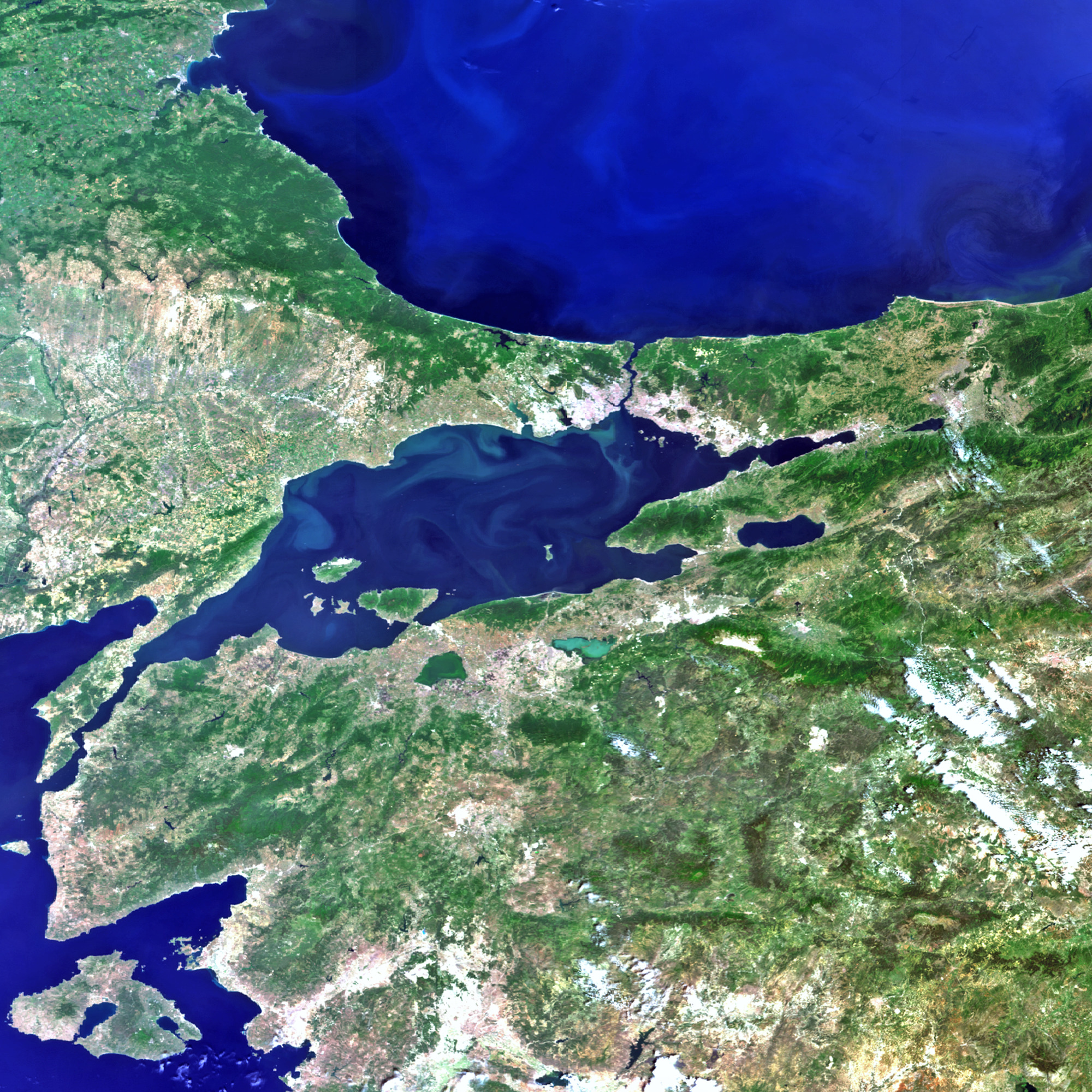
English: Istanbul and the surrounding area in northwestern Turkey are captured in this image acquired by Envisat’s MERIS instrument on 9 June 2011. To the north is the Black Sea, which connects to the Sea of Marmara (centre) via the Bosphorus strait. The Dardanelles strait connects the Marmara to the Aegean Sea (lower left corner). Turkey's largest city, Istanbul, is near the centre of the image at the Bosphorus strait. Istanbul straddles two continents (Europe and Asia), making it a true meeting place of the East and the West.
Turkey’s location makes it vulnerable to earthquakes, with the 1000 km-long North Anatolian fault just 15 km south of Istanbul. Because earthquakes can suddenly render current maps out of date, satellite images are useful for updating views of how the landscape has been affected as well as creating reference cartography for emergency operations. In addition, before and after satellite images of the area enable authoritative damage assessment as a basis for planning remedial action. |
| Datum | |
| Källa | http://www.esa.int/spaceinimages/Images/2013/05/Istanbul_Turkey |
| Skapare | European Space Agency |
| Tillstånd (Återanvändning av denna fil) |
ESA,CC BY-SA 3.0 IGO |
| Andra versioner |
|
| Title | Istanbul, Turkey |
| System | Envisat Satellite |
| Set | Earth observation image of the week |
| Location | Black Sea |
| Mission | Envisat |
| Activity | Observing the Earth |

Licensiering
Denna fil har gjorts tillgänglig under licensen Creative Commons Erkännande-DelaLika 3.0 Mellanstatlig organisation.
Erkännande: ESA
- Du är fri:
- att dela – att kopiera, distribuera och sända verket
- att remixa – att skapa bearbetningar
- På följande villkor:
- erkännande – Du måste ge lämpligt erkännande, ange en länk till licensen och indikera om ändringar har gjorts. Du får göra det på ett lämpligt sätt, men inte på ett sätt som antyder att licensgivaren stödjer dig eller din användning.
- dela lika – Om du remixar, transformerar eller bygger vidare på materialet måste du distribuera dina bidrag under samma eller en kompatibel licens som originalet.
Filhistorik
Klicka på ett datum/klockslag för att se filen som den såg ut då.
| Datum/Tid | Miniatyrbild | Dimensioner | Användare | Kommentar | |
|---|---|---|---|---|---|
| nuvarande | 22 februari 2017 kl. 02.46 | | 2 000 × 2 000 (1,61 Mbyte) | Revent | =={{int:filedesc}}== {{Photograph |photographer = Envisat satellite |title = Istanbul, Turkey |description = {{en|Istanbul and the surrounding area in northwestern Turkey are captured in this image acquired by Envisat’s M... |
Filanvändning
Följande sida använder den här filen: