Fil:EasternRomanEmpire.png
Det finns ingen version med högre upplösning.
EasternRomanEmpire.png (250 × 175 pixlar, filstorlek: 7 kbyte, MIME-typ: image/png)
| Denna fil tillhandahålls av Wikimedia Commons. Informationen nedan är kopierad från dess filbeskrivningssida. |

|
This map has been uploaded by Electionworld from en.wikipedia.org to enable the |

|
Det här verkets upphovsrättsinnehavare tillåter vem som helst att använda verket i vilket syfte som helst, inklusive obegränsad spridning, kommersiell användning och bearbetning.
|
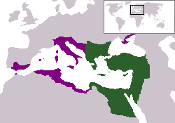
The territory in green represents the core areas held by the Eastern Roman Empire before the Muslim conquests The territory in purple represents the greatest extent of the Byzantine Empire under Emperor Justinian I
Filhistorik
Klicka på ett datum/klockslag för att se filen som den såg ut då.
| Datum/Tid | Miniatyrbild | Dimensioner | Användare | Kommentar | |
|---|---|---|---|---|---|
| nuvarande | 13 december 2006 kl. 20.27 | | 250 × 175 (7 kbyte) | Electionworld | {{ew|en|24630}} {{CopyrightedFreeUse-User|24630}} The territory in green represents the core areas held by the Eastern Roman Empire before the Muslim conquests The territory in purple represents the greatest extent of the Byzantine Empire unde |
Filanvändning
Följande sida använder den här filen:
Global filanvändning
Följande andra wikier använder denna fil:
- Användande på da.wikipedia.org
- Användande på en.wiktionary.org
- Användande på gd.wikipedia.org
- Användande på lv.wikipedia.org
- Användande på no.wikipedia.org
- Användande på ru.wiktionary.org
- Användande på sl.wikipedia.org
- Användande på sq.wikipedia.org
- Användande på vi.wikipedia.org
- Användande på zh.wiktionary.org