Fil:East-Hem 500bc.jpg

Originalfil (3 240 × 1 903 pixlar, filstorlek: 1,41 Mbyte, MIME-typ: image/jpeg)
| Denna fil tillhandahålls av Wikimedia Commons. Informationen nedan är kopierad från dess filbeskrivningssida. |

|
Denna bild (eller alla bilder i denna artikel eller kategori) bör återskapas med hjälp av vektorgrafik som en SVG-fil. Detta har flera fördelar; se Commons:Media for cleanup för mer information. Om det redan existerar en SVG-version av denna bild, var vänlig och lägg upp den. Efter att en SVG-version lagts upp, ersätt denna mall med {{vector version available|nytt bildnamn.svg}} på denna sida.
|


| Beskrivning |
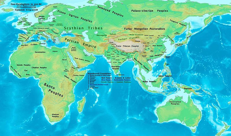
English: Eastern Hemisphere in 500 BC. |
| Källa | Eget arbete (For reference information, see below) |
| Skapare | Thomas Lessman (Contact!) |
| Tillstånd (Återanvändning av denna fil) |
Jag, upphovsrättsinnehavaren av detta verk, publicerar härmed det under följande licens: Denna fil har gjorts tillgänglig under licensen Creative Commons Erkännande-Dela Lika 3.0 Generisk
|
| Andra versioner | see below |
Map Summary
Original Source URL: http://www.thomaslessman.com/History/images/East-Hem_500bc.jpg.
This map of the Eastern Hemisphere in 500 BC was created by Thomas Lessman, based on information from the sources listed below. This map is free for educational use (see Permission info above). When using this map, please mention that it is available for free at www.WorldHistoryMaps.info.
Map Source References
- Remember, sources often conflict with each other. This map is only as accurate as the information that is available to me. To report any errors or to help further this work, please click here, or email Thomas Lessman at talessman@yis.us
Source References for information contained in this map:
Primary Sources for East-Hem_500bc:
- 1. The DK Atlas of World History, 2000 Edition
- 2. Wikipedia articles (noted below)
- 3. Wikimedia's map of the World 500 BCE, created by User:Briangotts.
I - African Information
Note: Most of the African Information I have for 500 BC derives from The DK Atlas of World History map of The World in 500 BCE (Pg 35), and map of The Development of Complex Societies in Africa (Pg 160).
- (Bantus, Berber Tribes, Carthage, Chadians, Cushites, Daamat, Garamantes, Gur, Khoisan Peoples, Kwa, Libyans, Mandes, Meroë, Nok Culture, Nilotic Peoples, West Atlantic Peoples)
- Carthage borders are derived from The DK Atlas of World History map of The Berber states and the Roman Empire; (Pg 161), which also shows Carthage borders in 500 BCE.
- Persian Egypt borders are derived from The DK Atlas of World History map of The Achaemenid Empire; (Pg 223).
II - Asian Information
Note 1: Much of the Asian information is derived from The DK Atlas of World History map of The World in 500 BCE (Pg 35)
. . . . (Ainu, Dravidians, Finno-Ugrians, Korean Peoples, Malay Peoples, Mon-Khmer Peoples, Palaeosiberians, Papuans, Saba, Samoyed Peoples, Scythian Tribes, Tochari/Yuezhi, Tungus)
Note 2: Information on other tribes derives from Briangott's map of the World 500 BCE.png and/or Wikipedia articles.
. . . . (Ainu, Final Jomon Culture, Korean Peoples, Massagetae, Sakae)
- Achaemenid Persian Empire borders are derived from:
- 1. The DK Atlas of World History map of The Achaemenid Empire c. 550-331 BCE; (Pg 223). (Provides the Achaemenid southern borders in north Arabia and Egypt and the eastern border along the Indus river).
- 2. The "Achaemenians" article and Map of Persia in 490 BCE archive copy at the Wayback Machine on www.Livius.org. (Provides the Achaemenid borders in India, Bactria, Central Asia, Oman, Armenia, and Thrace).
- Gerrha derives from the Wikipedia article about Gerrha.
- India information is derived from:
- 1. The DK Atlas of World History map of The World in 500 BCE; (Pg 35)
- 2. Wikimedia's map of Epic India.
- 3. Pennsylvania University's map of Republics and Kingdoms of Northern India, c. 600 BCE.
- Văn Lang borders are derived from:
- 1. Wikimedia's map of Van Lang, created by User:Briangotts.
- 2. Wikipedia's articles about Văn Lang and the Hồng Bàng Dynasty.
III - European Information
- The DK Atlas of World History map of The World in 500 BCE provides locations of:
- (Baltic Peoples, Finno-Ugrians, Illyrians, Samoyed Peoples, Scythians, Thracians)
1. Dbachmann's maps of Hallstatt LaTene 800-500 BCE and Hallstatt_culture.png
2. John Haywood's Atlas of the Celtic World archive copy at the Wayback Machine; London Thames & Hudson Ltd., 2001; Pgs.30-37.
3. Locations of many European cultures and peoples derive from various Wikipedia articles
- (Aquitani, Cantabri, Gaulic Veneti, Hallstatt Culture, Illyrians, Iron Age Europe, Jastorf Culture, Nordic Culture, Pomeranian Culture, Pre-Roman Iron Age, Silures, Vascones, etc.)
- Brythonic Celts derive from Wikipedia's article on the Brythons.
- Gaelic Celts and Priteni (aka Cruithne, Dál nAraidi, and Robogdii) derive from these sources:
- 1. Wikipedia's articles on Early History of Ireland, the Cruithne People, and Dál nAraidi.
- 2. This map of Iron-Age Ireland, available from the Ireland's History in Maps website.
- Gaulic Veneti are described in Wikipedia's article on Veneti (Gaul) and Dbachmann's Hallstatt LaTene 800-500 BCE map.
- Greek City-States and Greek Colonies information derives from:
- 1. The DK Atlas of World History section on The Mediterranean World, 700-300 BCE; (Pgs 176-177); (Section includes 2 maps of Greek mainland and colonies during this era).
- 2. Wikipedia's article about Greek Colonies in Antiquity, and Wikimedia's map of Greek & Phoenician Colonies, c. 550 BCE.
- Hallstatt Culture limits are derived from:
- 1. Dbachmann's map of Hallstatt LaTene 800-500 BCE.
- 2. Wikipedia's article about the Hallstatt Culture.
- Iberian Peoples derive from the Wikipedia articles about Pre-Roman peoples of the Iberian Peninsula, the Iberians and partially from this map of Ethnographic Iberia 200 BCE.
- (Cantabri, Celtiberians, Iberians, Lusitani, Tartessians, Vasconi, etc.)
- Italian Peninsula information comes from:
- 1. The DK Atlas of World History map of The Peoples of Italy in 500 BCE; (Pg 178)
- 2. Dbachmann's map of Iron Age Italy in 6th century BC.
- 3. Various Wikipedia articles (Bruttii, Etruscans, Ligures, Roman Republic, Umbrians, etc.)
- Thracian Tribes information is derived from:
- 1. Wikipedia's articles about the Thracians and Thraco-Cimmerians.
- 2. The section on Thracian History archive copy at the Wayback Machine on the Ancient Thrace and Thracology archive copy at the Wayback Machine website.
Note: Much of the data in this map was cross-checked with information on Bruce Gordon's Regnal Chronologies website.
Other Maps by Thomas Lessman
| Maps of the eastern hemisphere showing history
Bold dates are available on Wikimedia or Wikipedia. | ||
| Primeval | ||
| Ancient
|
·| 600 BC | 550 BC | 527 BC | 500 BC |
400 BC | ·| 1 AD | 50 AD | 100 AD | 200 AD | 300 AD | | |
| Medieval |
·| 500 AD | 565 AD | 600 AD | 700 AD | | |
| Modern |
·| 1500 AD | · * For historical maps of the whole world, | |
Filhistorik
Klicka på ett datum/klockslag för att se filen som den såg ut då.
| Datum/Tid | Miniatyrbild | Dimensioner | Användare | Kommentar | |
|---|---|---|---|---|---|
| nuvarande | 3 september 2016 kl. 14.46 | | 3 240 × 1 903 (1,41 Mbyte) | JournalmanManila | Update addition of Ifugao peoples in Luzon island: The Banaue Rice Terraces are 2,000-year-old terraces that were carved into the mountains of Ifugao in the Philippines by ancestors of the indigenous people |
| 3 september 2016 kl. 14.43 |  | 3 240 × 1 903 (1,41 Mbyte) | JournalmanManila | Update addition of Ifugao peoples in Luzon island: The Banaue Rice Terraces are 2,000-year-old terraces that were carved into the mountains of Ifugao in the Philippines by ancestors of the indigenous people. | |
| 2 augusti 2015 kl. 02.46 |  | 3 240 × 1 903 (905 kbyte) | History of Persia | Achaemenid borders were bigger. See wikipedia articles: Wars of Darius I & Achaemenid Arabia & Achaemenid Empire (Map featured on that article). I also added control over the red sea by the achaemenids, especially since Darius I created a kind of canal... | |
| 4 juni 2008 kl. 20.18 |  | 3 240 × 1 903 (713 kbyte) | Talessman | Numerous corrections, mostly minor, as well as various improvements | |
| 9 maj 2008 kl. 16.11 |  | 3 240 × 1 903 (715 kbyte) | Talessman | {{Information |Description='''Eastern Hemisphere in 500 BC'''. |Source=self-made (For reference information, see below) |Author=Thomas Lessman |Permission={{self|cc-by-sa-3.0}} |other_versions=see below }} |
Filanvändning
Följande sida använder den här filen:
Global filanvändning
Följande andra wikier använder denna fil:
- Användande på ar.wikipedia.org
- Användande på ast.wikipedia.org
- Användande på azb.wikipedia.org
- Användande på bs.wikipedia.org
- Användande på ca.wikipedia.org
- Användande på de.wikipedia.org
- Användande på el.wikipedia.org
- Användande på en.wikipedia.org
- 5th century BC
- 6th century BC
- 500s BC (decade)
- 500 BC
- User:Tompw/sandbox10
- User:Talessman/Maps
- User talk:Talessman/Maps
- Timeline of ancient history
- List of political entities in the 6th century BC
- List of political entities in the 5th century BC
- User:Benjamin Trovato/sandbox
- User:Falcaorib
- User:Kypioys sx/sandbox
- Användande på en.wikibooks.org
- Användande på es.wikipedia.org
- Användande på eu.wikipedia.org
- Användande på fa.wikipedia.org
- Användande på fr.wikipedia.org
- Användande på gl.wikipedia.org
- Användande på it.wikipedia.org
- Användande på ko.wikipedia.org
- Användande på lv.wikipedia.org
- Användande på mk.wikipedia.org
- Användande på ro.wikipedia.org
- Användande på ru.wikipedia.org
- Användande på sh.wikipedia.org
- Användande på si.wikipedia.org
- Användande på ta.wikipedia.org
- Användande på vi.wikipedia.org
- Användande på zh.wikibooks.org