Fil:Different map projections.png

Storlek på förhandsvisningen: 800 × 352 pixlar. Andra upplösningar: 320 × 141 pixlar | 1 049 × 462 pixlar.
Originalfil (1 049 × 462 pixlar, filstorlek: 166 kbyte, MIME-typ: image/png)
| Denna fil tillhandahålls av Wikimedia Commons. Informationen nedan är kopierad från dess filbeskrivningssida. |
Sammanfattning
| Beskrivning |
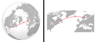
English: This image describes how different map projections can create illusions. The image to the left is an orthographic projection of the northern Atlantic Ocean and the image to the right is a Robinson projection of the same area. The red line on both images is an air route between Stockholm and New York. The two lines are placed on the same coordinates but on the orthographic projection the line is straight and on the Robinson projection the line is bent. |
| Datum | |
| Källa | |
| Skapare |
|
.svg)
Licensiering
Denna fil har gjorts tillgänglig under licensen Creative Commons Erkännande-Dela Lika 3.0 Generisk
- Du är fri:
- att dela – att kopiera, distribuera och sända verket
- att remixa – att skapa bearbetningar
- På följande villkor:
- erkännande – Du måste ge lämpligt erkännande, ange en länk till licensen och indikera om ändringar har gjorts. Du får göra det på ett lämpligt sätt, men inte på ett sätt som antyder att licensgivaren stödjer dig eller din användning.
- dela lika – Om du remixar, transformerar eller bygger vidare på materialet måste du distribuera dina bidrag under samma eller en kompatibel licens som originalet.
Filhistorik
Klicka på ett datum/klockslag för att se filen som den såg ut då.
| Datum/Tid | Miniatyrbild | Dimensioner | Användare | Kommentar | |
|---|---|---|---|---|---|
| nuvarande | 1 april 2011 kl. 11.38 | | 1 049 × 462 (166 kbyte) | AnonMoos | cropping |
| 27 mars 2011 kl. 16.08 |  | 1 063 × 531 (170 kbyte) | Poxnar | correction | |
| 14 mars 2011 kl. 02.13 |  | 1 063 × 531 (237 kbyte) | Poxnar | {{Created with Inkscape}} {{Information |Description={{en|This image describes how different map projections can create illusions. The image to the left is an orthographic projection of |
Filanvändning
Följande 2 sidor använder den här filen:
Global filanvändning
Följande andra wikier använder denna fil:
- Användande på es.wikipedia.org
- Användande på nl.wikipedia.org