Fil:Deception Island Map.svg

Storleken för denna PNG-förhandsvisning av denna SVG-fil: 644 × 599 pixlar. Andra upplösningar: 258 × 240 pixlar | 516 × 480 pixlar | 825 × 768 pixlar | 1 101 × 1 024 pixlar | 2 201 × 2 048 pixlar | 820 × 763 pixlar.
Originalfil (SVG-fil, standardstorlek: 820 × 763 pixlar, filstorlek: 461 kbyte)
| Denna fil tillhandahålls av Wikimedia Commons. Informationen nedan är kopierad från dess filbeskrivningssida. |
| Beskrivning |
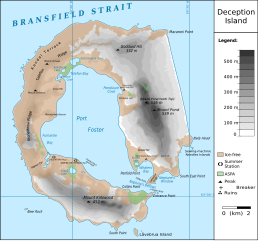
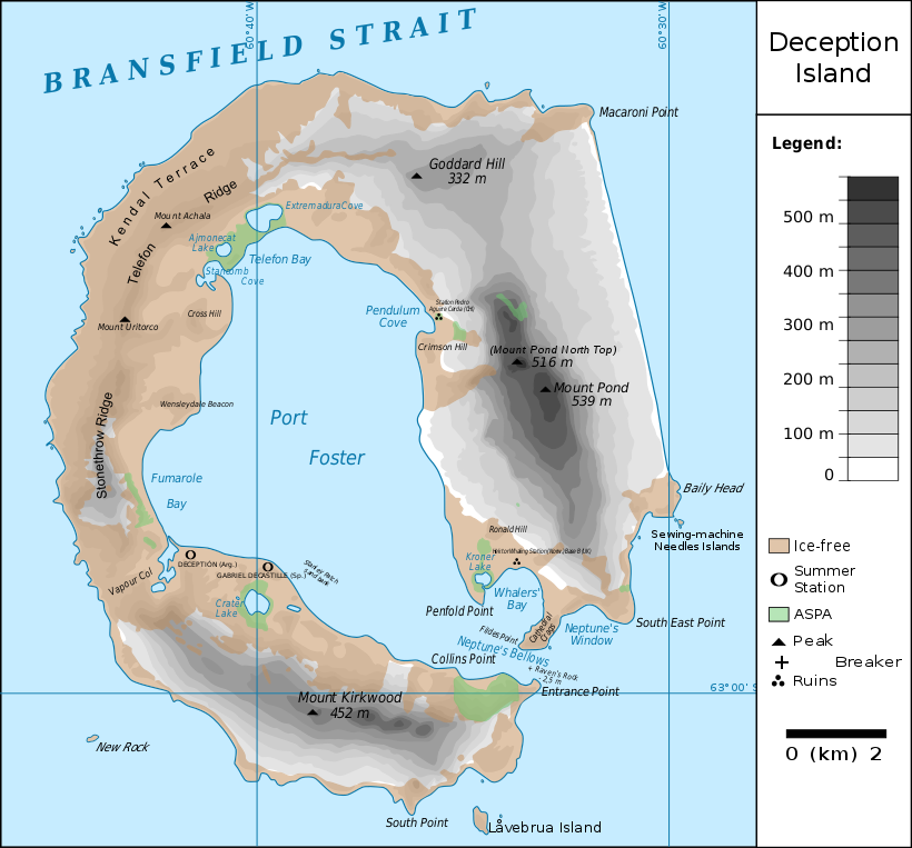
Français : carte de l'île de la Déception avec les toponymes + la position des stations ainsi que des zones protégées
English: map of Deception Island with the topography and the location of the stations and protected zones |
| Datum | (UTC) |
| Källa | |
| Skapare |
|
| Detta är en retuscherad eller på annat sätt behandlad bild, med vilket menas att den har redigerats digitalt från sitt original. Redigeringar: {{{1}}}. Originalet kan ses här: Ile de la Deception.svg. Redigeringar gjorda av Fitzgabbro.
|
Jag, upphovsrättsinnehavaren av detta verk, publicerar härmed det under följande licenser:
Denna fil har gjorts tillgänglig under licensen Creative Commons Erkännande 3.0 Generisk
- Du är fri:
- att dela – att kopiera, distribuera och sända verket
- att remixa – att skapa bearbetningar
- På följande villkor:
- erkännande – Du måste ge lämpligt erkännande, ange en länk till licensen och indikera om ändringar har gjorts. Du får göra det på ett lämpligt sätt, men inte på ett sätt som antyder att licensgivaren stödjer dig eller din användning.

|
Tillstånd ges att kopiera, distribuera och/eller modifiera detta dokument under villkoren i GNU Free Documentation License, Version 1.2 eller senare version publicerad av Free Software Foundation, utan oföränderliga avsnitt, framsidestexter eller baksidestexter. En kopia av licensen ingår i avsnittet GNU Free Documentation License. |
Du får själv välja den licens du vill använda.
Ursprunglig uppladdningslogg
This image is a derivative work of the following images:
- File:Ile_de_la_Deception.svg licensed with Cc-by-3.0, GFDL
- 2010-06-19T09:08:35Z Treehill 820x763 (464885 Bytes) carrés noirs (tentative)
- 2010-06-18T17:48:51Z Treehill 820x763 (465569 Bytes) deux dernières légendes alignées
- 2010-06-18T17:30:49Z Treehill 820x763 (465601 Bytes) nom de la baie à gauche
- 2010-06-18T17:20:48Z Treehill 820x763 (465594 Bytes) déplacement de certains textes + 1ère tentative de suppression des carrés
- 2010-06-18T14:02:39Z Treehill 820x763 (465599 Bytes) {{Information |Description={{fr|1=carte de l'île de la Déception avec les toponymes + la position des stations ainsi que des zones protégées}} |Source={{own}} |Author=[[User:Treehill|Treehill]] |Date= |Permission= |other_
Uploaded with derivativeFX
Filhistorik
Klicka på ett datum/klockslag för att se filen som den såg ut då.
| Datum/Tid | Miniatyrbild | Dimensioner | Användare | Kommentar | |
|---|---|---|---|---|---|
| nuvarande | 13 maj 2018 kl. 23.59 | | 820 × 763 (461 kbyte) | Hogweard | Rm duplicate |
| 25 mars 2018 kl. 14.45 |  | 820 × 763 (462 kbyte) | Hogweard | Corrected height of Pond North Top; Fumarole Bay and additional names. | |
| 18 september 2016 kl. 18.35 |  | 820 × 763 (459 kbyte) | Maproom | 1.) Word "Station" no longer extends off edge of image 2.) "Peak" is spelled without a ffinal "t" 3.) "Breaker" is written in the right place instead of overwritten on "peak" | |
| 10 oktober 2010 kl. 13.01 |  | 820 × 763 (459 kbyte) | Fitzgabbro | Fixed curved writing | |
| 10 oktober 2010 kl. 00.11 |  | 820 × 763 (353 kbyte) | Fitzgabbro | {{Information |Description={{fr|1=carte de l'île de la Déception avec les toponymes + la position des stations ainsi que des zones protégées}} {{en|1=map of Deception Island with the topography and the location of the stations and protected zones}} |S |
Filanvändning
Följande sida använder den här filen:
Global filanvändning
Följande andra wikier använder denna fil:
- Användande på ceb.wikipedia.org
- Användande på cs.wikipedia.org
- Användande på de.wikipedia.org
- Deception Island
- Mount Achala
- Telefon Ridge
- Telefon Bay
- Port Foster
- Ajmonecatsee
- Stancomb Cove
- Laguna Hill
- Fildes Point
- Neptunes Bellows
- Whalers Bay
- Penfold Point
- Collins Point
- Crater Lake (Deception Island)
- Mount Kirkwood
- Entrance Point
- Crimson Hill
- Kendall Terrace
- Kroner Lake
- Låvebrua Island
- South Point (Deception Island)
- New Rock (Südliche Shetlandinseln)
- Mount Pond
- Primero de Mayo Bay
- Ravn Rock
- Ronald Hill
- South East Point
- Stonethrow Ridge
- Vapour Col
- Användande på en.wikipedia.org
- Användande på eu.wikipedia.org
- Användande på it.wikipedia.org
- Användande på ja.wikipedia.org
- Användande på lld.wikipedia.org
- Användande på nds.wikipedia.org
- Användande på nl.wikipedia.org
- Användande på nn.wikipedia.org
- Användande på pl.wikipedia.org
- Användande på ru.wikipedia.org
Visa mer globalt användande av denna fil.