Fil:De facto cantons of Rojava.png

Storlek på förhandsvisningen: 725 × 599 pixlar. Andra upplösningar: 290 × 240 pixlar | 581 × 480 pixlar | 929 × 768 pixlar | 1 239 × 1 024 pixlar | 2 000 × 1 653 pixlar.
Originalfil (2 000 × 1 653 pixlar, filstorlek: 268 kbyte, MIME-typ: image/png)
| Denna fil tillhandahålls av Wikimedia Commons. Informationen nedan är kopierad från dess filbeskrivningssida. |

|
Denna bild (eller alla bilder i denna artikel eller kategori) bör återskapas med hjälp av vektorgrafik som en SVG-fil. Detta har flera fördelar; se Commons:Media for cleanup för mer information. Om det redan existerar en SVG-version av denna bild, var vänlig och lägg upp den. Efter att en SVG-version lagts upp, ersätt denna mall med {{vector version available|nytt bildnamn.svg}} på denna sida.
|
Sammanfattning
| Beskrivning |
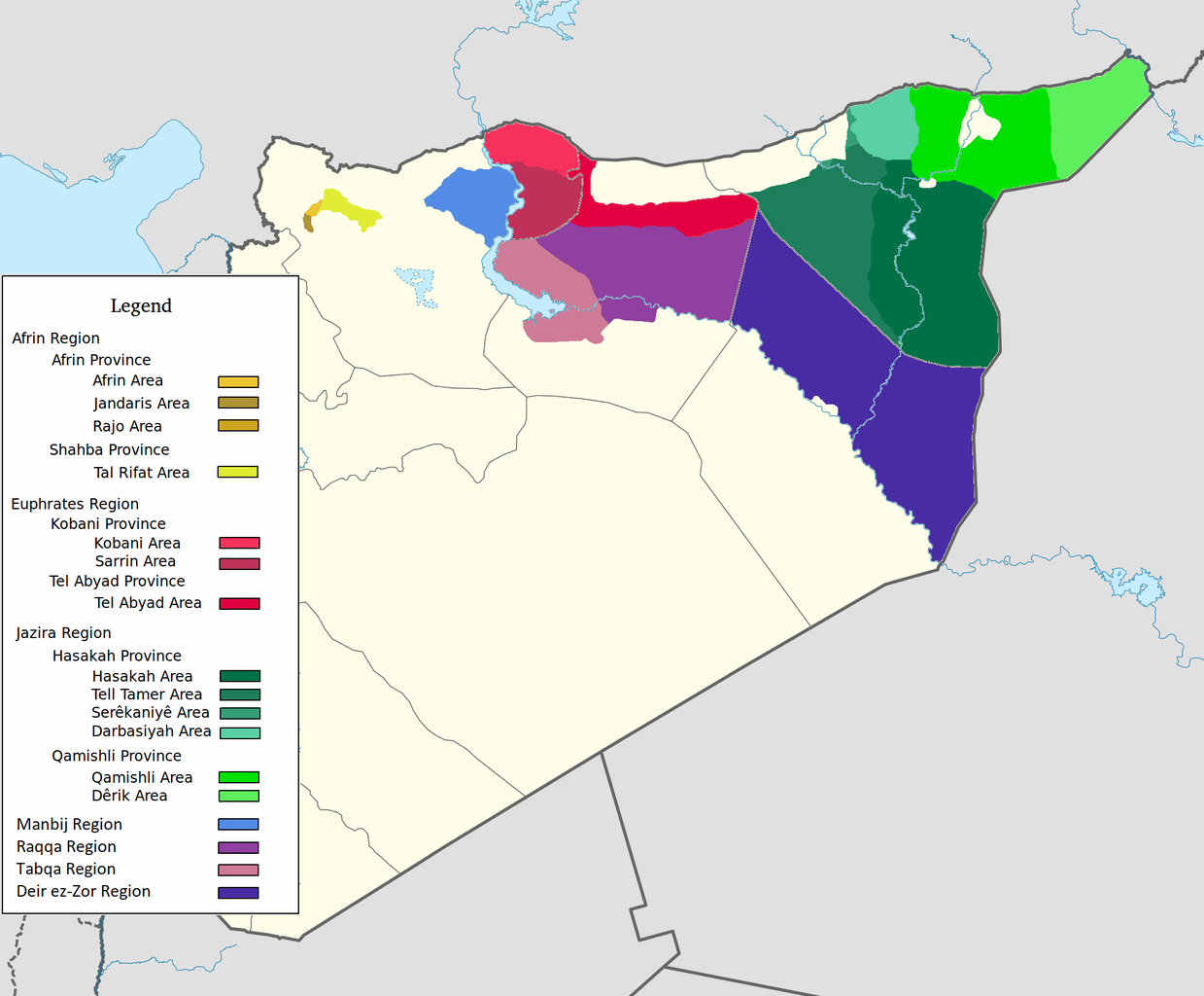
العربية: اقليم عفرين اقليم الفرات اقليم الجزيرة English: Afrin Region Euphrates Region Jazeera Region No region 한국어: 아프린 주 유프라테스 주 자제라 주 없음 |
| Datum | |
| Källa | Eget arbete |
| Skapare | Editor abcdef |
| Andra versioner |
Den här bilden innehåller hämtade eller omarbetade delar av den här filen:  |
Licensiering
Jag, upphovsrättsinnehavaren av detta verk, publicerar härmed det under följande licens:
Denna fil har gjorts tillgänglig under licensen Creative Commons Erkännande-Dela Lika 3.0 Generisk
- Du är fri:
- att dela – att kopiera, distribuera och sända verket
- att remixa – att skapa bearbetningar
- På följande villkor:
- erkännande – Du måste ge lämpligt erkännande, ange en länk till licensen och indikera om ändringar har gjorts. Du får göra det på ett lämpligt sätt, men inte på ett sätt som antyder att licensgivaren stödjer dig eller din användning.
- dela lika – Om du remixar, transformerar eller bygger vidare på materialet måste du distribuera dina bidrag under samma eller en kompatibel licens som originalet.
Filhistorik
Klicka på ett datum/klockslag för att se filen som den såg ut då.
| Datum/Tid | Miniatyrbild | Dimensioner | Användare | Kommentar | |
|---|---|---|---|---|---|
| nuvarande | 27 maj 2020 kl. 10.29 | | 2 000 × 1 653 (268 kbyte) | AntonSamuel | Reverted to version as of 09:02, 8 April 2020 (UTC) Restoring original map without stripes per COM:OW and discussion on the Rojava talk page on Wikipedia |
| 8 april 2020 kl. 11.05 |  | 2 000 × 1 653 (224 kbyte) | Bill497 | Reverted to version as of 08:59, 8 April 2020 (UTC) Revert vandalism. | |
| 8 april 2020 kl. 11.02 |  | 2 000 × 1 653 (268 kbyte) | AntonSamuel | Reverted to version as of 08:51, 8 April 2020 (UTC) Third, and last warning given on user talk page. | |
| 8 april 2020 kl. 10.59 |  | 2 000 × 1 653 (224 kbyte) | Bill497 | Reverted to version as of 08:11, 8 April 2020 (UTC) Revert vandalism for a 3rd time. User is reverting a referenced map to an unreferenced version. | |
| 8 april 2020 kl. 10.51 |  | 2 000 × 1 653 (268 kbyte) | AntonSamuel | Reverted to version as of 17:57, 7 April 2020 (UTC) Once again, use the Rojava talk page to discuss before making reverts and don't throw around unfounded vandalism claims. Second warning on talk page given. | |
| 8 april 2020 kl. 10.11 |  | 2 000 × 1 653 (224 kbyte) | Bill497 | Reverted to version as of 11:10, 7 April 2020 (UTC) Revert vandalism. | |
| 7 april 2020 kl. 19.57 |  | 2 000 × 1 653 (268 kbyte) | AntonSamuel | Reverted to version as of 00:50, 7 April 2020 (UTC) Restoring viewable version - Use Rojava talk page, warning left on user talk page | |
| 7 april 2020 kl. 13.10 |  | 2 000 × 1 653 (224 kbyte) | Bill497 | Reverted to version as of 12:33, 2 April 2020 (UTC) Revert attempted vandalism into a factually incorrect version of the map. SDF has entirely no presence in some of the dashed zones. Due to fog of war these areas are all displaced as mixed with government control. Russia is the only reliable source displaying where the government is present. | |
| 7 april 2020 kl. 02.50 |  | 2 000 × 1 653 (268 kbyte) | AntonSamuel | Continuation from below: ...manner. Further sources are needed apart from the Russian military maps - they cannot be considered to be neutral or factually accurate without additional verification. | |
| 7 april 2020 kl. 02.46 |  | 2 000 × 1 653 (218 kbyte) | AntonSamuel | Clearing the 50/50 paint because of the visual difficulty and for deviation from the main purpose of this map - which is to display the various subregions of the civilian administration of the de facto autonomous region, not military control agreements such as SDF-SAA/Russia and SDF-US/US-led coalition which have no known civilian aspect as of date. Please discuss the issue first and foremost on the Rojava talk page if areas with an SAA/Russian or a US presence need to be highlighted in some... |
Filanvändning
Inga sidor använder den här filen.
Global filanvändning
Följande andra wikier använder denna fil:
- Användande på ar.wikipedia.org
- Användande på arz.wikipedia.org
- Användande på azb.wikipedia.org
- Användande på ca.wikipedia.org
- Användande på diq.wikipedia.org
- Användande på fa.wikipedia.org
- Användande på glk.wikipedia.org
- Användande på id.wikipedia.org
- Användande på ku.wikipedia.org
- Användande på nl.wikipedia.org
- Användande på ru.wikipedia.org
- Användande på tr.wikipedia.org
- Användande på vi.wikipedia.org
- Användande på www.wikidata.org
- Användande på zh.wikipedia.org