Fil:Curacao-CIA WFB Map.png
Det finns ingen version med högre upplösning.
Curacao-CIA_WFB_Map.png (325 × 349 pixlar, filstorlek: 11 kbyte, MIME-typ: image/png)
| Denna fil tillhandahålls av Wikimedia Commons. Informationen nedan är kopierad från dess filbeskrivningssida. |
Sammanfattning
| Beskrivning |
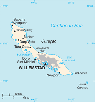
English: Map of Curaçao from the 2010-10-22 revision of the World Factbook |
| Datum | |
| Källa | World Factbook website |
| Skapare | Directorate of Intelligence, CIA |
Licensiering
This image is in the public domain because it contains materials that originally came from the United States Central Intelligence Agency's World Factbook.
|
 |
Filhistorik
Klicka på ett datum/klockslag för att se filen som den såg ut då.
| Datum/Tid | Miniatyrbild | Dimensioner | Användare | Kommentar | |
|---|---|---|---|---|---|
| nuvarande | 23 maj 2018 kl. 13.13 | | 325 × 349 (11 kbyte) | Ras67 | cropped, opt. |
| 23 oktober 2010 kl. 13.21 |  | 330 × 353 (13 kbyte) | Hoshie | {{Information |Description= Map of {{w|Curaçao}} from the 2010-10-22 revision of the World Factbook |Source= [https://www.cia.gov/library/publications/the-world-factbook/maps/maptemplate_cc.html World Factbook website] |Date= 2010-10-22 |Author= Director |
Filanvändning
Inga sidor använder den här filen.
Global filanvändning
Följande andra wikier använder denna fil:
- Användande på als.wikipedia.org
- Användande på ast.wikipedia.org
- Användande på ba.wikipedia.org
- Användande på be-tarask.wikipedia.org
- Användande på br.wikipedia.org
- Användande på ca.wikipedia.org
- Användande på cs.wikipedia.org
- Användande på de.wikipedia.org
- Användande på en.wikipedia.org
- Användande på es.wikipedia.org
- Användande på eu.wikipedia.org
- Användande på fi.wikipedia.org
- Användande på frr.wikipedia.org
- Användande på ga.wikipedia.org
- Användande på gl.wikipedia.org
- Användande på he.wikipedia.org
- Användande på hu.wikipedia.org
- Användande på id.wikipedia.org
- Användande på incubator.wikimedia.org
- Användande på io.wikipedia.org
- Användande på ja.wikipedia.org
- Användande på ms.wikipedia.org
- Användande på mt.wikipedia.org
- Användande på nn.wikipedia.org
- Användande på no.wikipedia.org
- Användande på pl.wikipedia.org
- Användande på pl.wiktionary.org
- Användande på ru.wikipedia.org
- Användande på sl.wikipedia.org
- Användande på sw.wikipedia.org
- Användande på ta.wikipedia.org
- Användande på th.wikipedia.org
- Användande på to.wikipedia.org
- Användande på tt.wikipedia.org
- Användande på uk.wikipedia.org
- Användande på ur.wikipedia.org
- Användande på vi.wikipedia.org
Visa mer globalt användande av denna fil.