Fil:Cerro Bayo volcanic complex.jpg
Det finns ingen version med högre upplösning.
Cerro_Bayo_volcanic_complex.jpg (640 × 422 pixlar, filstorlek: 76 kbyte, MIME-typ: image/jpeg)
| Denna fil tillhandahålls av Wikimedia Commons. Informationen nedan är kopierad från dess filbeskrivningssida. |
Sammanfattning
| Beskrivning |
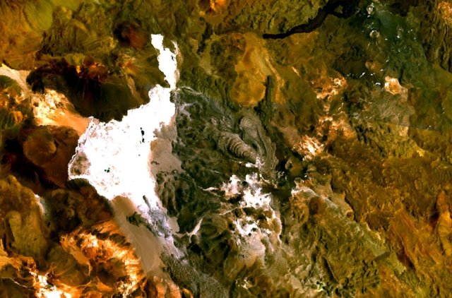
English: The Cerro Bayo volcanic complex lies along the Chile-Argentina border east of the Salar de Gorbea, the light-colored area at the left-center portion of this NASA Landsat image. A young well-preserved crater can be seen NE of an older snow-covered center (bottom-center). A younger northern center along the national border has a well-preserved 400-m-wide crater. The 5401-m-high summit of the Cerro Bayo complex, located west of the border in Chile, is the source of two viscous dacitic lava flows with prominent levees that traveled to the north. |
| Datum | Okänt datum |
| Källa | http://www.volcano.si.edu/world/volcano.cfm?vnum=1505-122&volpage=photos&photo=115041 |
| Skapare | NASA Landsat7 image (worldwind.arc.nasa.gov) |
Licensiering
| This image is in the public domain because it is a screenshot from NASA’s globe software World Wind using a public domain layer, such as Blue Marble, MODIS, Landsat, SRTM, USGS or GLOBE.
|
 |
Filhistorik
Klicka på ett datum/klockslag för att se filen som den såg ut då.
| Datum/Tid | Miniatyrbild | Dimensioner | Användare | Kommentar | |
|---|---|---|---|---|---|
| nuvarande | 23 augusti 2010 kl. 11.43 | | 640 × 422 (76 kbyte) | Michael Metzger | {{Information |Description={{en|1=The Cerro Bayo volcanic complex lies along the Chile-Argentina border east of the Salar de Gorbea, the light-colored area at the left-center portion of this NASA Landsat image. A young well-preserved crater can be seen NE |
Filanvändning
Följande sida använder den här filen:
Global filanvändning
Följande andra wikier använder denna fil:
- Användande på arz.wikipedia.org
- Användande på de.wikipedia.org
- Användande på en.wikipedia.org
- Användande på eo.wikipedia.org
- Användande på es.wikipedia.org
- Användande på eu.wikipedia.org
- Användande på fa.wikipedia.org
- Användande på fr.wikipedia.org
- Användande på it.wikipedia.org
- Användande på pt.wikipedia.org
- Användande på ru.wikipedia.org
- Användande på uk.wikipedia.org
- Användande på www.wikidata.org