Fil:Carol in Rhode Island.jpg
Storlek på förhandsvisningen: 662 × 599 pixlar. Andra upplösningar: 265 × 240 pixlar | 530 × 480 pixlar | 848 × 768 pixlar | 1 131 × 1 024 pixlar | 1 308 × 1 184 pixlar.
Originalfil (1 308 × 1 184 pixlar, filstorlek: 1,79 Mbyte, MIME-typ: image/jpeg)
| Denna fil tillhandahålls av Wikimedia Commons. Informationen nedan är kopierad från dess filbeskrivningssida. |
Sammanfattning
|
This is an image of a place or building that is listed on the National Register of Historic Places in the United States of America. Its reference number is 89000072. |
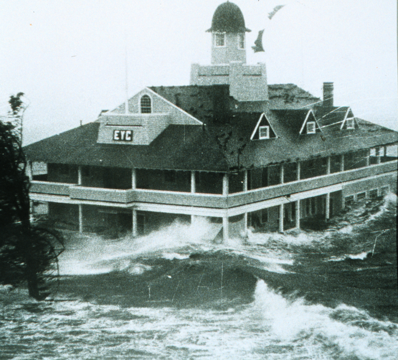
Storm surge from w:Hurricane Carol lashes the Edgewood Yacht Club. Author unknown.
Source: NOAA Photo Library
Licensiering
This image is in the public domain because it contains materials that originally came from the U.S. National Oceanic and Atmospheric Administration, taken or made as part of an employee's official duties.
|
| Objektposition | | Se denna och andra närliggande bilder på: OpenStreetMap |
|---|
Filhistorik
Klicka på ett datum/klockslag för att se filen som den såg ut då.
| Datum/Tid | Miniatyrbild | Dimensioner | Användare | Kommentar | |
|---|---|---|---|---|---|
| nuvarande | 26 december 2005 kl. 05.25 | | 1 308 × 1 184 (1,79 Mbyte) | Jdorje~commonswiki | Storm surge from Hurricane Carol lashes the Rhode Island Yacht Club. Source: [http://www.photolib.noaa.gov/historic/nws/wea00407.htm NOAA Photo Library] == Licensing == {{PD-USGov-NOAA}} |
Filanvändning
Följande sida använder den här filen:
Global filanvändning
Följande andra wikier använder denna fil:
- Användande på ar.wikipedia.org
- Användande på ca.wikipedia.org
- Användande på en.wikipedia.org
- Talk:Meramec River
- Talk:Great Mississippi Flood of 1927
- Talk:1997 Red River flood
- Talk:Johnstown Flood
- Talk:Drop (liquid)
- Talk:Great Flood of 1993
- Talk:Banqiao Dam
- Talk:Levee
- Talk:1931 China floods
- Talk:Great Sheffield Flood
- Hurricane Carol
- Talk:Flash flood
- Talk:North Sea flood of 1953
- Talk:Maharashtra floods of 2005
- Talk:2005 Gujarat flood
- Talk:2005 European floods
- Wikipedia:WikiProject Tropical cyclones
- Talk:Northeast U.S. flooding of October 2005
- Talk:St. Lucia's flood
- Talk:St. Elizabeth's flood (1404)
- Talk:All Saints' Flood (1570)
- List of retired Atlantic hurricane names
- Talk:1974 Brisbane flood
- List of New England hurricanes
- Portal talk:Weather
- Talk:Glacial lake outburst flood
- Talk:1878 flood in Miskolc
- Talk:2006 European floods
- Talk:Flood control in the Netherlands
- Talk:2006 New England flood
- Talk:1938 Yellow River flood
- Talk:Willamette Valley flood of 1996
- Talk:2006 Mid-Atlantic United States flood
- Talk:St. Felix's flood
- Talk:Floods in the United States (1900–1999)
- Talk:Kissimmee River
- Talk:2006 North Korean floods
- Talk:1978 Singapore flood
- Talk:1998 China floods
- Talk:2002 European floods
- Talk:St. Elizabeth's flood (1421)
- Category talk:Yellow River floods
- Talk:Burchardi flood
- Talk:National Flood Insurance Program
- Talk:May 1995 Louisiana flood
- Talk:Great Flood of 1951
- Talk:Flash flood warning
- Talk:2003 Santa Fe flood
Visa mer globalt användande av denna fil.