Fil:Accreting coast Image6.svg

Storleken för denna PNG-förhandsvisning av denna SVG-fil: 800 × 377 pixlar. Andra upplösningar: 320 × 151 pixlar | 640 × 301 pixlar | 1 024 × 482 pixlar | 1 280 × 602 pixlar | 2 560 × 1 205 pixlar | 1 481 × 697 pixlar.
Originalfil (SVG-fil, standardstorlek: 1 481 × 697 pixlar, filstorlek: 15 kbyte)
| Denna fil tillhandahålls av Wikimedia Commons. Informationen nedan är kopierad från dess filbeskrivningssida. |
Sammanfattning
| Beskrivning |
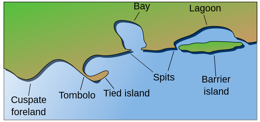
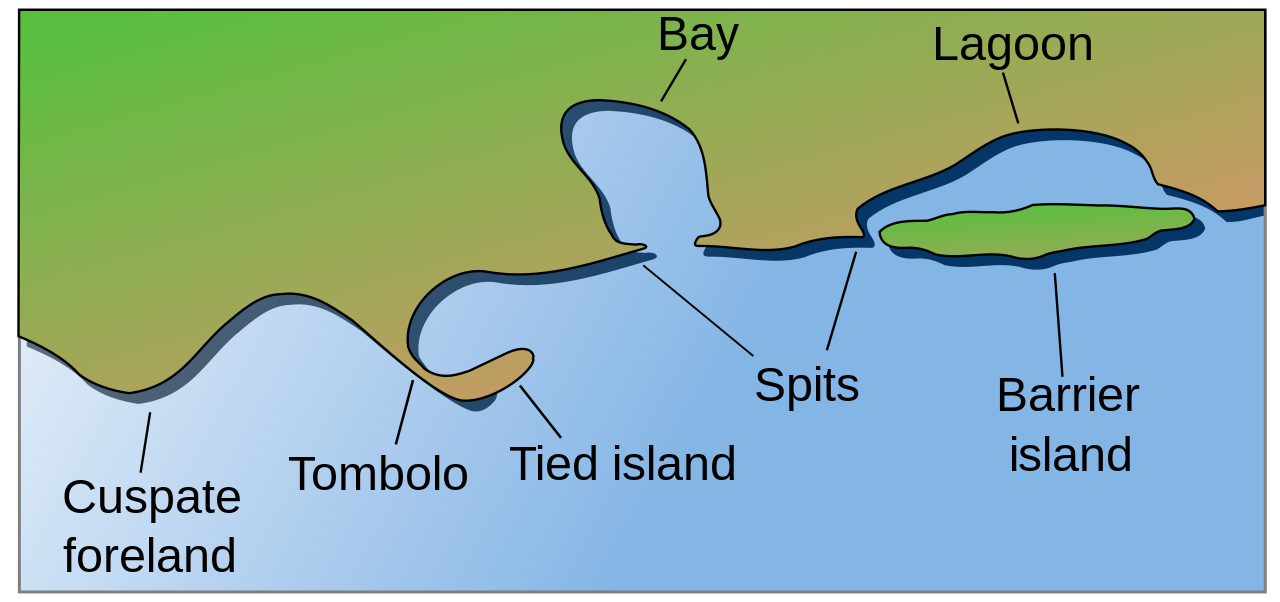
English: Coastal and oceanic landforms. Cuspate foreland, tombolo, spit, bay, lagoon, barrier island. |
| Datum | |
| Källa | self-made SVG, based on the public domain PNG Accreting coast Image6.png by Feydey |
| Skapare | Surachit |
| Andra versioner |
Derivative works of this file: Accreting coast Image6-ta.svg
|
| SVG utveckling |


Licensiering
| Detta verk har gjorts tillgänglig som public domain av dess skapare, Feydey. Detta gäller globalt. I vissa länder kan detta inte vara juridiskt möjligt; i så fall: |
Filhistorik
Klicka på ett datum/klockslag för att se filen som den såg ut då.
| Datum/Tid | Miniatyrbild | Dimensioner | Användare | Kommentar | |
|---|---|---|---|---|---|
| nuvarande | 16 maj 2022 kl. 06.17 | | 1 481 × 697 (15 kbyte) | Bacon Noodles | Fixed background (water) alignment |
| 12 februari 2018 kl. 03.49 |  | 1 481 × 697 (15 kbyte) | Howpper | Added tied island. A Tombolo is what connects a Tied island to the mainland, so it would be exclusive to not include both features. | |
| 16 augusti 2007 kl. 23.48 |  | 1 481 × 697 (13 kbyte) | Surachit | {{Information |Description=Coastal and oceanic landforms. Cuspate foreland, tombolo, spit, bay, lagoon, barrier island. |Source=self-made SVG, based on the public domain PNG [http://en.wikipedia.org/wiki/Image:Accreting_coast_Image6.png] by [http://en.wik |
Filanvändning
Följande sida använder den här filen:
Global filanvändning
Följande andra wikier använder denna fil:
- Användande på ar.wikipedia.org
- Användande på az.wikipedia.org
- Användande på bh.wikipedia.org
- Användande på chr.wikipedia.org
- Användande på cs.wikipedia.org
- Användande på en.wikipedia.org
- Archipelago
- Coast
- Dune
- Island
- List of peninsulas
- Beach
- Fjord
- Atoll
- Strait
- Boulder
- Estuary
- Natural arch
- Lagoon
- Coral reef
- Firth
- Isthmus
- Gulf of California
- Coastal erosion
- Talk:Beach
- River delta
- Cliff
- Reef
- Islet
- Salt marsh
- Tombolo
- Stack (geology)
- Cove
- Shoal
- Spit (landform)
- Longshore drift
- Ria
- Barrier island
- Emergent coastline
- Submergent coastline
- Groyne
- Rip current
- Pebble
- Discordant coastline
- Wave-cut platform
Visa mer globalt användande av denna fil.