Originalfil(3 044 × 2 000 pixlar, filstorlek: 13,79 Mbyte, MIME-typ: image/png)

Beskrivning
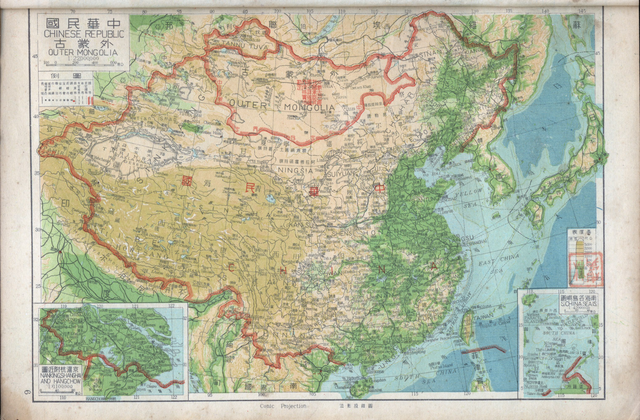
中文(简体):1947年出版的中华民国地图和外蒙古地图。图中的南海诸岛的名称仍使用旧称。1947年中华民国地图,此图中注明「外蒙古已经我国承认其独立」。此图中南海四沙仍然沿用旧名。
English: Map of the Chinese Republic and Outer Mongolia published in 1947. The names of the South China Sea Islands (Nanhai Zhudao) in the map still used old names. At the top of the map in 1947, which indicates that Outer Mongolia has been recognized for independence by the government of the Republic of China, and show the border between China and Mongolia.
Datum
Källa https://www.nansha.org.cn/maps/3/1947_ROC_Map.jpg
Skapare
Tillstånd
(Återanvändning av denna fil)
Public domain
This image is now in the public domain in China because its term of copyright has expired.

According to copyright laws of the People's Republic of China (with legal jurisdiction in the mainland only, excluding Hong Kong and Macao), amended November 11, 2020, Works of legal persons or organizations without legal personality, or service works, or audiovisual works, enter the public domain 50 years after they were first published, or if unpublished 50 years from creation. For photography works of natural persons whose copyright protection period expires before June 1, 2021 belong to the public domain. All other works of natural persons enter the public domain 50 years after the death of the creator.
According to copyright laws of Republic of China (currently with jurisdiction in Taiwan, Penghu, Kinmen, Matsu, etc.), all photographs and cinematographic works, and all works whose copyright holder is a juristic person, enter the public domain 50 years after they were first published, or if unpublished 50 years from creation, and all other applicable works enter the public domain 50 years after the death of the creator.

Important note: Works of foreign (non-U.S.) origin must be out of copyright or freely licensed in both their home country and the United States in order to be accepted on Commons. Works of Chinese origin that have entered the public domain in the U.S. due to certain circumstances (such as publication in noncompliance with U.S. copyright formalities) may have had their U.S. copyright restored under the Uruguay Round Agreements Act (URAA) if the work was under copyright in its country of origin on the date that the URAA took effect in that country. (For the People's Republic of China, the URAA took effect on January 1, 1996. For the Republic of China (ROC), the URAA took effect on January 1, 2002.[1])
To uploader: Please provide where the image was first published and who created it or held its copyright.

Du måste även inkludera en tagg för allmän egendom i USA för att indikera varför detta verk är allmän egendom i USA. Note that this work might not be in the public domain in countries that do not apply the rule of the shorter term and have copyright terms longer than life of the author plus 50 years. In particular, Mexico is 100 years, Jamaica is 95 years, Colombia is 80 years, Guatemala and Samoa are 75 years, Switzerland and the United States are 70 years, and Venezuela is 60 years.


čeština  Deutsch  English  português  română  slovenščina  Tagalog  Tiếng Việt  македонски  русский  മലയാളം  ไทย  한국어  日本語  简体中文‎  繁體中文  +/−


Bildtexter

Ingen bildtext har definierats
1947 map of the Republic of China and Outer Mongolia

Objekt som porträtteras i den här filen

motiv

image/png

b1e14a1cca041a78e5378d71dcf4c8e1fb1716ca

14 457 441 byte

2 000 pixel

3 044 pixel

Filhistorik

Klicka på ett datum/klockslag för att se filen som den såg ut då.

Datum/TidMiniatyrbildDimensionerAnvändareKommentar
nuvarande7 maj 2019 kl. 04.18Miniatyrbild för versionen från den 7 maj 2019 kl. 04.183 044 × 2 000 (13,79 Mbyte)TmReverted to version as of 12:27, 6 May 2008 (UTC)
7 maj 2019 kl. 02.12Miniatyrbild för versionen från den 7 maj 2019 kl. 02.121 600 × 1 119 (3,35 Mbyte)Aerbaniyaedit
6 maj 2008 kl. 14.27Miniatyrbild för versionen från den 6 maj 2008 kl. 14.273 044 × 2 000 (13,79 Mbyte)Shibo77中文说明: 为1947年出版的中华民国地图和南洋群岛图。图中的南海诸岛的名称仍使用旧称。1947年中华民国地图,此图中注明外蒙古已经被民国政府批准独立。此图中南海四沙仍然沿用旧名。 {{P

Följande sida använder den här filen:

Global filanvändning

Följande andra wikier använder denna fil:

Metadata