Fil:Weser basin topo.png

Storlek på förhandsvisningen: 358 × 599 pixlar. Andra upplösningar: 143 × 240 pixlar | 286 × 480 pixlar | 458 × 768 pixlar | 611 × 1 024 pixlar | 2 544 × 4 260 pixlar.
Originalfil (2 544 × 4 260 pixlar, filstorlek: 14,31 Mbyte, MIME-typ: image/png)
| Denna fil tillhandahålls av Wikimedia Commons. Informationen nedan är kopierad från dess filbeskrivningssida. |
Sammanfattning
| Beskrivning |
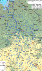
English: Topographic map of Weser River system, with English description |
| Datum | |
| Källa | Eget arbete |
| Skapare | Ulamm (diskussion) |
| Andra versioner | File:Weser Flusssystem topo.png, German version |
Licensiering
Jag, upphovsrättsinnehavaren av detta verk, publicerar härmed det under följande licenser:

|
Tillstånd ges att kopiera, distribuera och/eller modifiera detta dokument under villkoren i GNU Free Documentation License, Version 1.2 eller senare version publicerad av Free Software Foundation, utan oföränderliga avsnitt, framsidestexter eller baksidestexter. En kopia av licensen ingår i avsnittet GNU Free Documentation License. |
This file is licensed under the Creative Commons Attribution-Share Alike 4.0 International, 3.0 Unported, 2.5 Generic, 2.0 Generic and 1.0 Generic license.
- Du är fri:
- att dela – att kopiera, distribuera och sända verket
- att remixa – att skapa bearbetningar
- På följande villkor:
- erkännande – Du måste ge lämpligt erkännande, ange en länk till licensen och indikera om ändringar har gjorts. Du får göra det på ett lämpligt sätt, men inte på ett sätt som antyder att licensgivaren stödjer dig eller din användning.
- dela lika – Om du remixar, transformerar eller bygger vidare på materialet måste du distribuera dina bidrag under samma eller en kompatibel licens som originalet.
Du får själv välja den licens du vill använda.
Filhistorik
Klicka på ett datum/klockslag för att se filen som den såg ut då.
| Datum/Tid | Miniatyrbild | Dimensioner | Användare | Kommentar | |
|---|---|---|---|---|---|
| nuvarande | 24 maj 2021 kl. 21.22 | | 2 544 × 4 260 (14,31 Mbyte) | Ulamm | Schleusenkanal Landesbergen |
| 9 februari 2018 kl. 12.05 |  | 2 544 × 4 260 (14,31 Mbyte) | Ulamm | two little corrections | |
| 8 februari 2018 kl. 19.11 |  | 2 544 × 4 260 (14,31 Mbyte) | Ulamm | 4 names corrected | |
| 26 april 2017 kl. 00.54 |  | 2 544 × 4 260 (14,31 Mbyte) | Ulamm | flow marks a bit bigger | |
| 24 april 2017 kl. 17.21 |  | 2 544 × 4 260 (14,31 Mbyte) | Ulamm | Klosterbach & Lippstadt | |
| 23 april 2017 kl. 22.08 |  | 2 544 × 4 260 (14,32 Mbyte) | Ulamm | some more names | |
| 23 april 2017 kl. 04.02 |  | 2 544 × 4 260 (14,32 Mbyte) | Ulamm | one more bifurcation | |
| 22 april 2017 kl. 00.43 |  | 2 544 × 4 260 (14,32 Mbyte) | Ulamm | three more rivers, one more place | |
| 21 april 2017 kl. 21.10 |  | 2 544 × 4 260 (14,32 Mbyte) | Ulamm | 3 x Bever | |
| 21 april 2017 kl. 18.17 |  | 2 544 × 4 260 (14,34 Mbyte) | Ulamm | discharge directions of Vehne river and Hamme-Oste-Kanal |
Filanvändning
Följande sida använder den här filen:
Global filanvändning
Följande andra wikier använder denna fil:
- Användande på azb.wikipedia.org
- Användande på bg.wikipedia.org
- Användande på en.wikipedia.org
- Användande på et.wikipedia.org
- Användande på fr.wikipedia.org
- Användande på hr.wikipedia.org
- Användande på it.wikipedia.org
- Användande på nl.wikipedia.org
- Användande på ru.wikipedia.org
- Användande på sw.wikipedia.org
- Användande på uk.wikipedia.org