Fil:Shetland UK relief location map.jpg

Storlek på förhandsvisningen: 315 × 599 pixlar. Andra upplösningar: 126 × 240 pixlar | 252 × 480 pixlar | 404 × 768 pixlar | 538 × 1 024 pixlar | 1 999 × 3 802 pixlar.
Originalfil (1 999 × 3 802 pixlar, filstorlek: 505 kbyte, MIME-typ: image/jpeg)
| Denna fil tillhandahålls av Wikimedia Commons. Informationen nedan är kopierad från dess filbeskrivningssida. |
| Beskrivning |
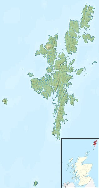
Relief map of the Shetland Islands, UK. Equirectangular map projection on WGS 84 datum, with N/S stretched 200% Geographic limits:
|
| Datum | |
| Källa |
|
| Skapare | Nilfanion, created using Ordnance Survey data |
| Tillstånd (Återanvändning av denna fil) |
Denna fil har gjorts tillgänglig under licensen Creative Commons Erkännande-Dela Lika 3.0 Generisk Erkännande: Contains Ordnance Survey data © Crown copyright and database right
|
| Andra versioner | File:Shetland UK blank map.svg - Blank map |
Filhistorik
Klicka på ett datum/klockslag för att se filen som den såg ut då.
| Datum/Tid | Miniatyrbild | Dimensioner | Användare | Kommentar | |
|---|---|---|---|---|---|
| nuvarande | 30 november 2011 kl. 14.29 | | 1 999 × 3 802 (505 kbyte) | Nilfanion | {{Information |Description=Relief map of the Shetland Islands, UK. Equirectangular map projection on WGS 84 datum, with N/S stretched 200% Geographic limits: *West: 2.15W *East: 0.70W *North: 60.88N *South: 59.50N |Source=[[w:Ordn |
Filanvändning
Mer än 100 sidor använder den här filen. Följande lista visar bara de 100 första sidorna som använder filen. Det finns en fullständig lista.
- Bay of Quendale
- Bay of Scousburgh
- Bigga (ö)
- Bressay
- East Burra
- Hermaness
- Hildasay
- Holm of Maywick
- Holm of Melby
- Holm of Sandwick
- Holm of Skaw
- Holm of West Sandwick
- Hoo Stack
- Horse Island, Shetlandsöarna
- Housay
- Hoy, Shetlandsöarna
- Hunder Holm
- Huney
- Huxter
- Inner Flaess
- Inner Holm of Skaw
- Isbister Holm
- Isle of Nibon
- Isle of Stenness
- Isle of West Burrafirth
- Kay Holm
- Kettla Ness
- Kirk Ness (halvö i Storbritannien)
- Lady's Holm
- Lamba (ö)
- Lang Holm
- Langa, Skottland
- Lerwick
- Linga, Bluemull Sound
- Linga, Busta Voe
- Linga, Scalloway Islands
- Linga, Yell Sound
- Linga Sound (sund i Storbritannien, Shetlandsöarna)
- Little Havra
- Little Holm
- Little Linga, Shetlandsöarna
- Little Roe
- Little Skerry, Shetlandsöarna
- Loch of Spiggie
- Lunna Holm
- Lunna Ness
- Mooa
- Muckle Holm
- Muckle Ossa
- Muckle Roe
- Ness of Sound
- Nista
- North Benelip
- North Havra
- North Holm of Burravoe
- North Holms
- North Isle of Gletness
- Orfasay
- Out Skerries
- Out Stack
- Outer Holm of Skaw
- Oxna
- Papa, Shetlandsöarna
- Papa Little
- Papa Stour
- Ramna Stacks
- Ronas Voe
- Round Holm
- Rumble Holm
- Samphrey
- Sand Voe
- Sandwick
- Sound Gruney
- South Benelip
- South Havra
- South Holm of Burravoe
- South Holms
- South Isle of Gletness
- St Magnus Bay
- St Ninian's Isle
- Sullom Voe
- Sumburgh Head
- Suther Ness
- Symbister Ness
- The Vere (ö i Storbritannien, lat 60,70, long -0,82)
- The Vere (ö i Storbritannien, lat 60,73, long -0,98)
- Trondra
- Urie Lingey
- Uyea
- Uyea, Northmavine
- Uynarey
- Vaila
- Ve Skerries
- Vementry
- Wedder Holm
- West Burra
- West Linga
- West Voe of Sumburgh
- Wether Holm (ö i Storbritannien, lat 60,37, long -1,02)
- Wether Holm (ö i Storbritannien, lat 60,43, long -1,15)
Visa fler länkar till den här filen.
Global filanvändning
Följande andra wikier använder denna fil:
- Användande på ar.wikipedia.org
- Användande på ast.wikipedia.org
- Användande på bg.wikipedia.org
- Användande på ca.wikipedia.org
- Användande på ceb.wikipedia.org
- Användande på da.wikipedia.org
- Användande på de.wikipedia.org
- Användande på de.wikivoyage.org
- Användande på en.wikipedia.org
Visa mer globalt användande av denna fil.