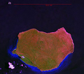
Fil:Mona Landsat7 Pseudo.png

Storlek på förhandsvisningen: 680 × 599 pixlar. Andra upplösningar: 272 × 240 pixlar | 545 × 480 pixlar | 690 × 608 pixlar.
Originalfil (690 × 608 pixlar, filstorlek: 1,2 Mbyte, MIME-typ: image/png)
Filhistorik
Klicka på ett datum/klockslag för att se filen som den såg ut då.
| Datum/Tid | Miniatyrbild | Dimensioner | Användare | Kommentar | |
|---|---|---|---|---|---|
| nuvarande | 19 februari 2007 kl. 20.48 |  | 690 × 608 (1,2 Mbyte) | Ratzer | NASA World Wind screen image Landsat 7 Pseudo color Mona Island, Puerto Rico |
Filanvändning
Följande sida använder den här filen:
Global filanvändning
Följande andra wikier använder denna fil:
- Användande på arz.wikipedia.org
- Användande på br.wikipedia.org
- Användande på ca.wikipedia.org
- Användande på ceb.wikipedia.org
- Användande på cs.wikipedia.org
- Användande på el.wikipedia.org
- Användande på en.wikipedia.org
- Användande på en.wikivoyage.org
- Användande på es.wikipedia.org
- Användande på et.wikipedia.org
- Användande på eu.wikipedia.org
- Användande på fa.wikipedia.org
- Användande på it.wikivoyage.org
- Användande på ja.wikipedia.org
- Användande på ko.wikipedia.org
- Användande på pl.wikipedia.org
- Användande på sw.wikipedia.org
- Användande på szl.wikipedia.org
- Användande på tr.wikipedia.org
- Användande på tt.wikipedia.org
- Användande på ur.wikipedia.org
- Användande på vec.wikipedia.org
- Användande på www.wikidata.org
- Användande på zh.wikipedia.org
