Fil:Blaisdell Arena, Ward Avenue and Kapiolani Boulevard, Kakaako, Honolulu, HI - 52263934326.jpg

Storlek på förhandsvisningen: 800 × 600 pixlar. Andra upplösningar: 320 × 240 pixlar | 640 × 480 pixlar | 1 024 × 768 pixlar | 1 280 × 960 pixlar | 2 560 × 1 920 pixlar | 4 032 × 3 024 pixlar.
Originalfil (4 032 × 3 024 pixlar, filstorlek: 3,43 Mbyte, MIME-typ: image/jpeg)
| Denna fil tillhandahålls av Wikimedia Commons. Informationen nedan är kopierad från dess filbeskrivningssida. |
Sammanfattning
| Beskrivning |
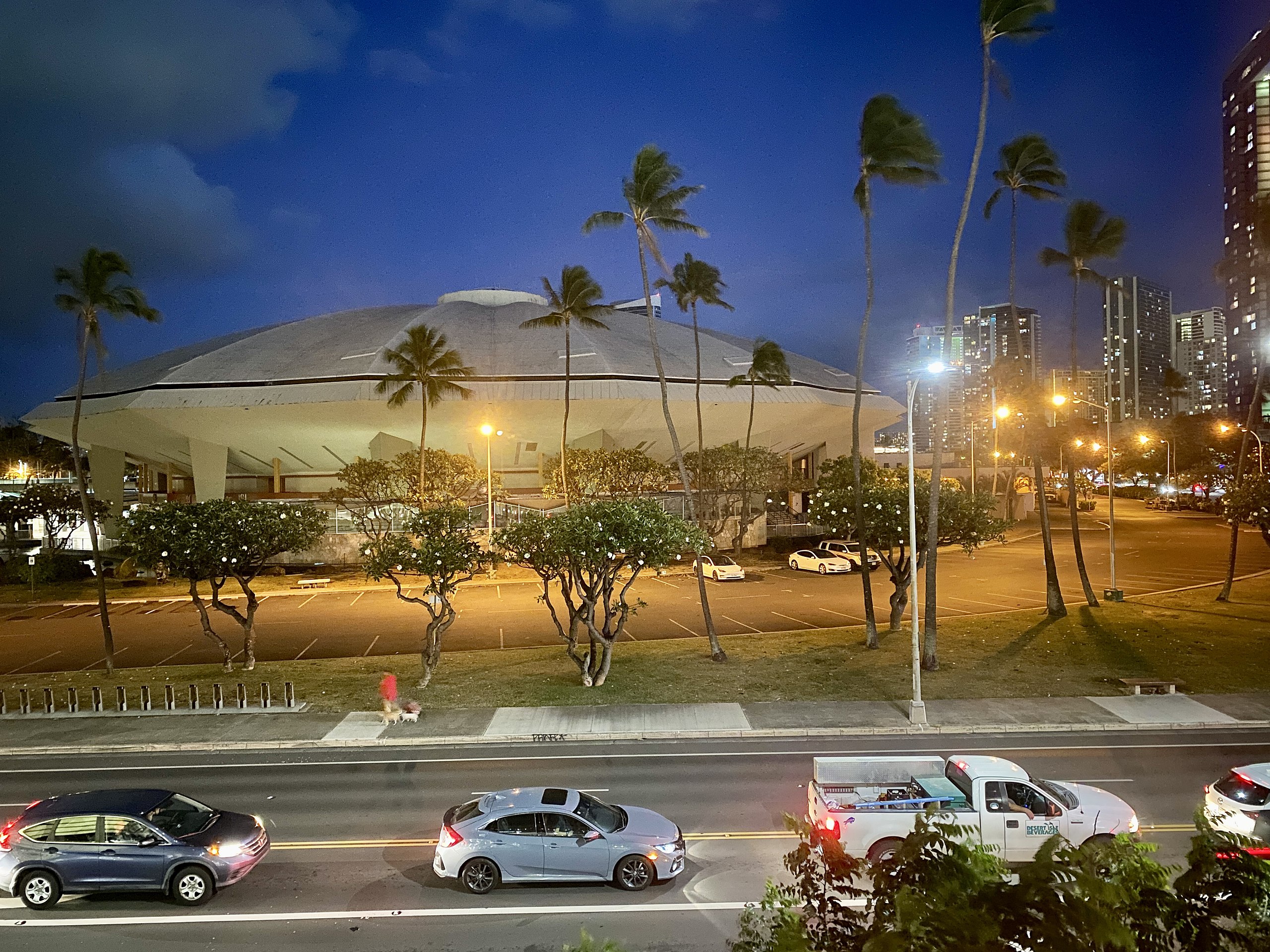
English: Completed in 1964, this Modern arena was designed by Adrian Wilson & Associates in conjunction with the master plan laid out by the firm Merril, Simms & Roehrig, and was known as the Honolulu International Center until 1976, when it was renamed in honor of former Honolulu Mayor Neil S. Blaisdell. The building features a Saarinen-esque sculptural exterior with a large clamshell-like domed roof made up of multiple segments that bends sharply at the edges of the building before curving underneath, forming a ceiling above the exterior concourse, tapered concrete columns at the exterior, one-story service wings in the front and rear with concrete butterfly roofs and columns, rustic stone cladding, and curtain walls on the upper portion of the exteriors, exterior staircases, a pond surrounding the rear and sides of the arena with a distinctive mid century modern sculpture that compliments the arena, and a breezeway connecting the arena to the adjacent Neal S. Blaisdell Convention Center. The arena, being one of the best examples of architecture inspired by the work of Eero Saarinen’s modern sculptural designs, is sadly endangered by a proposed renovation that would greatly alter the building’s concourses, adding a large glass curtain wall, removing the unique “mushroom”-like sculpture that sits in the pond behind the building, and completely obscure the tapered columns, as well as demolishing the service buildings that sit alongside the concourse. Additionally, the plans call for the demolition of the adjacent Neal S. Blaisdell Center and Blaisdell Concert Hall, irreparably harming the historic modern design of the concert hall and destroying what is left of the 1960s portion of the Blaisdell Center. Hopefully, a design far more sensitive to the original design of the modernist structures will be carried out. |
| Datum | |
| Källa | https://www.flickr.com/photos/59081381@N03/52263934326/ |
| Skapare | w_lemay |
| Kameraposition | | Se denna och andra närliggande bilder på: OpenStreetMap |
|---|
Licensiering
Denna fil har gjorts tillgänglig under licensen Creative Commons Erkännande-Dela Lika 2.0 Generisk
- Du är fri:
- att dela – att kopiera, distribuera och sända verket
- att remixa – att skapa bearbetningar
- På följande villkor:
- erkännande – Du måste ge lämpligt erkännande, ange en länk till licensen och indikera om ändringar har gjorts. Du får göra det på ett lämpligt sätt, men inte på ett sätt som antyder att licensgivaren stödjer dig eller din användning.
- dela lika – Om du remixar, transformerar eller bygger vidare på materialet måste du distribuera dina bidrag under samma eller en kompatibel licens som originalet.
| Denna bild laddades ursprungligen upp på Flickr av w_lemay på https://flickr.com/photos/59081381@N03/52263934326. 14 mars 2023 granskades den av roboten FlickreviewR 2 och befanns vara licensierad under licensen cc-by-sa-2.0. |
Filhistorik
Klicka på ett datum/klockslag för att se filen som den såg ut då.
| Datum/Tid | Miniatyrbild | Dimensioner | Användare | Kommentar | |
|---|---|---|---|---|---|
| nuvarande | 14 mars 2023 kl. 22.54 | | 4 032 × 3 024 (3,43 Mbyte) | Ser Amantio di Nicolao | Uploaded a work by w_lemay from https://www.flickr.com/photos/59081381@N03/52263934326/ with UploadWizard |
Filanvändning
Följande sida använder den här filen: