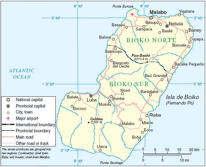
Fil:Bioko.png
Bioko.png (684 × 553 pixlar, filstorlek: 61 kbyte, MIME-typ: image/png)
Filhistorik
Klicka på ett datum/klockslag för att se filen som den såg ut då.
| Datum/Tid | Miniatyrbild | Dimensioner | Användare | Kommentar | |
|---|---|---|---|---|---|
| nuvarande | 14 april 2006 kl. 20.25 |  | 684 × 553 (61 kbyte) | KillOrDie | Area de Bioko de la imágen: http://commons.wikimedia.org/wiki/Image:Annobón Bioko.PNG Fuente: http://www.un.org/Depts/Cartographic/map/profile/eqguinea.pdf {{PD}} |
Filanvändning
Följande sida använder den här filen:
Global filanvändning
Följande andra wikier använder denna fil:
- Användande på ar.wikipedia.org
- Användande på arz.wikipedia.org
- Användande på ast.wikipedia.org
- Användande på azb.wikipedia.org
- Användande på bcl.wikipedia.org
- Användande på bg.wikipedia.org
- Användande på ca.wikipedia.org
- Användande på cs.wikipedia.org
- Användande på cy.wikipedia.org
- Användande på da.wikipedia.org
- Användande på de.wikipedia.org
- Användande på el.wikipedia.org
- Användande på en.wikipedia.org
- Användande på en.wikiversity.org
- Användande på eo.wikipedia.org
- Användande på eu.wikipedia.org
- Användande på fa.wikipedia.org
- Användande på frr.wikipedia.org
- Användande på fr.wikipedia.org
- Användande på gl.wikipedia.org
- Användande på hr.wikipedia.org
- Användande på hu.wikipedia.org
- Användande på id.wikipedia.org
- Användande på is.wikipedia.org
- Användande på it.wikipedia.org
- Användande på it.wikivoyage.org
- Användande på ja.wikipedia.org
- Användande på ka.wikipedia.org
- Användande på ko.wikipedia.org
- Användande på la.wikipedia.org
- Användande på lt.wikipedia.org
- Användande på mk.wikipedia.org
- Användande på nl.wikipedia.org
- Användande på no.wikipedia.org
- Användande på oc.wikipedia.org
- Användande på pl.wikipedia.org
- Användande på pt.wikipedia.org
Visa mer globalt användande av denna fil.

